This post describes what it was like to take a “Photography Tour” of Lower Antelope Canyon back in 2015. Unfortunately, in the years that have passed since then, quite a lot has changed. Today, both Upper and Lower Antelope Canyon are all but overwhelmed by visitors, an enormous increase in numbers, with the crowds growing larger every year. Given that there’s no longer any slack in the schedule, the tour operators are no longer willing to accommodate the slower pace and smaller groups required for photo tours. Result: photo tours are no longer available, not at either location. You can still take pictures, of course, but you can’t use a tripod, you can’t take extra time, and they most definitely won’t hold back the crowd for you while you compose your perfect shot. Pity. All of that was really nice while it lasted! Under the circumstances, this post is a historical record of the good old days! Antelope Canyon has joined the ranks of iconic destinations that have been severely diminished by marketing that succeeded a bit too well–and once the word gets out, there’s just no putting it back.
AND NOW, THE LIGHT BEAMS!
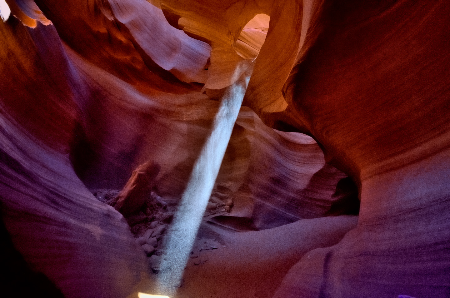
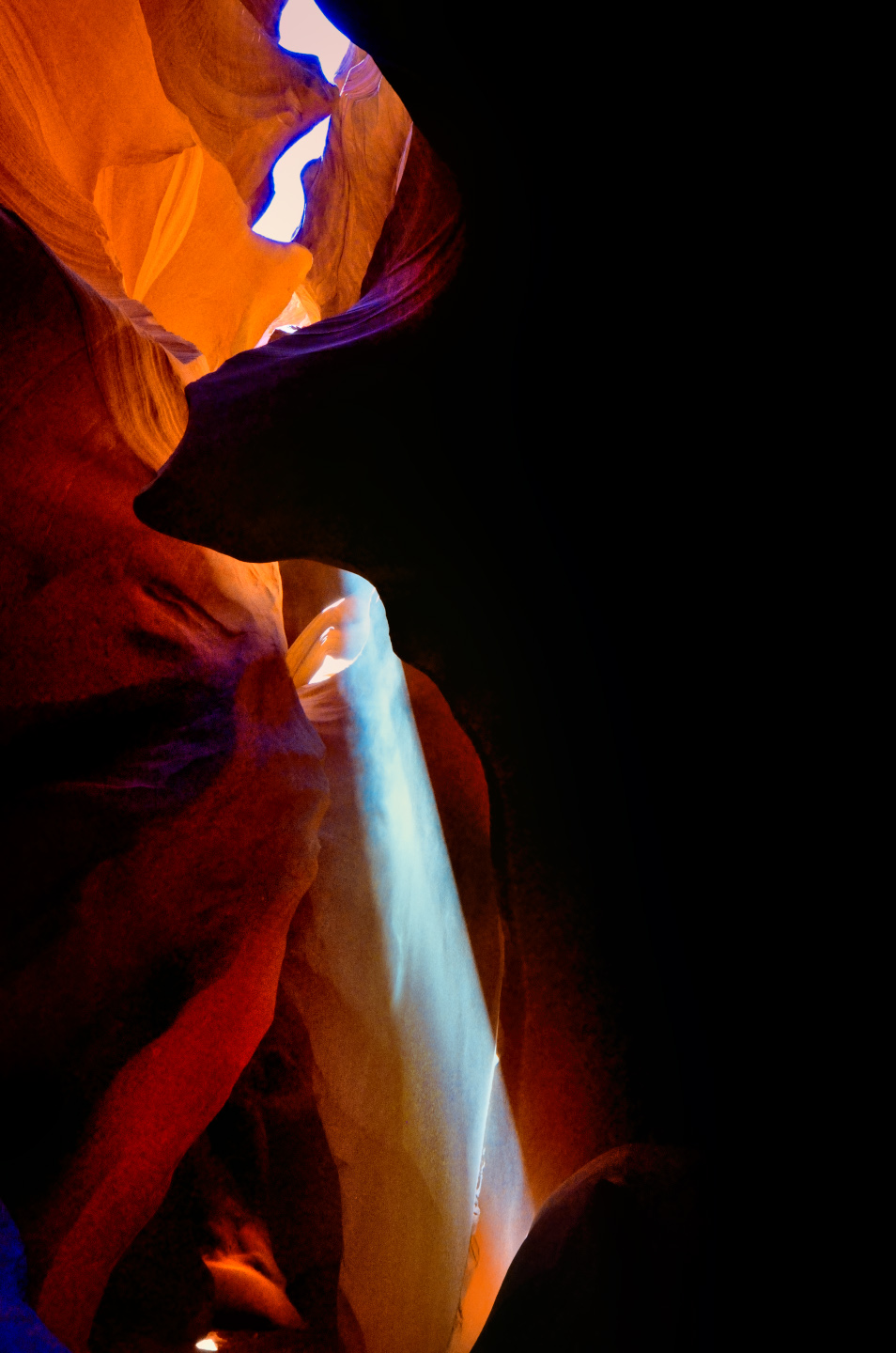
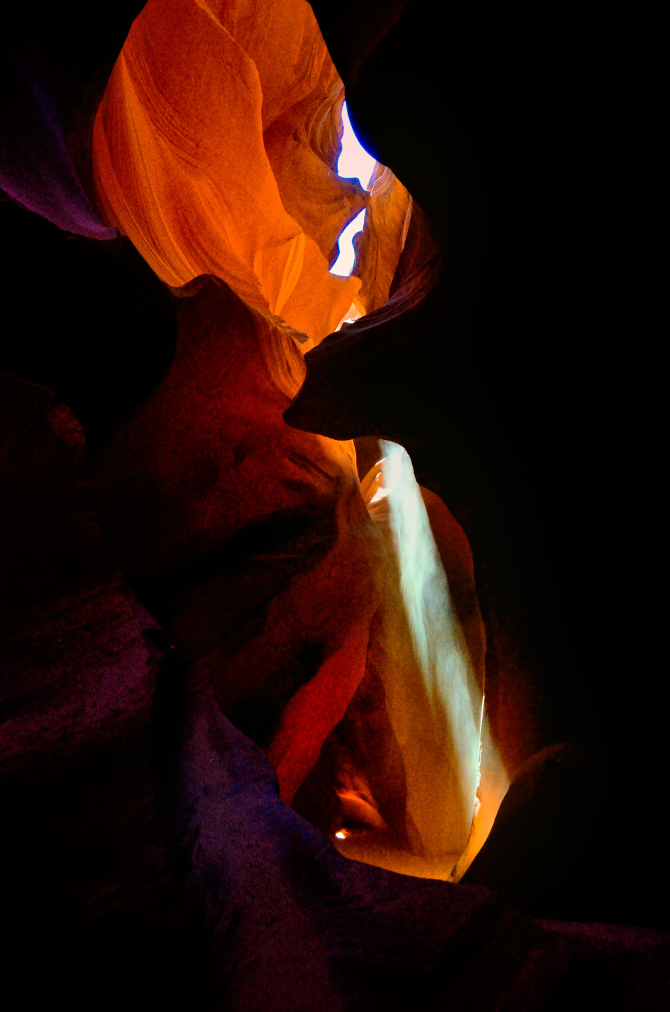
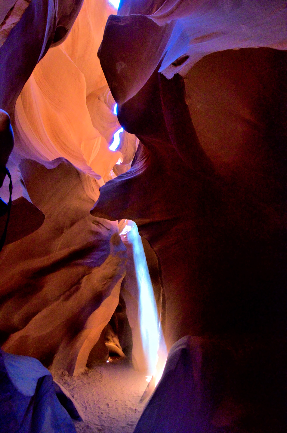
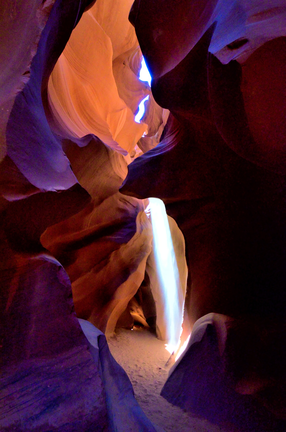
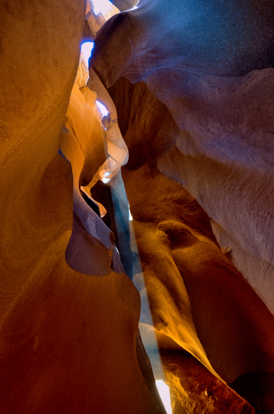
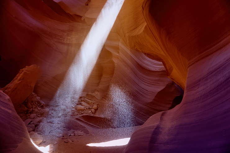
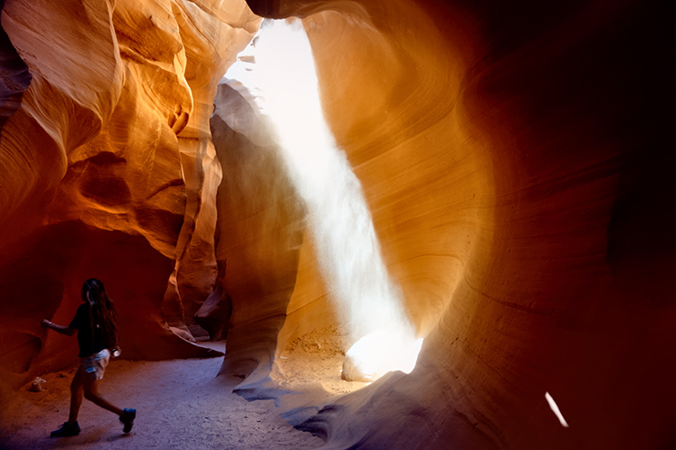
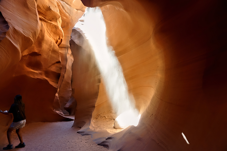
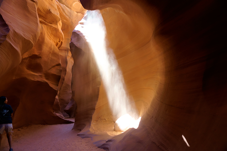
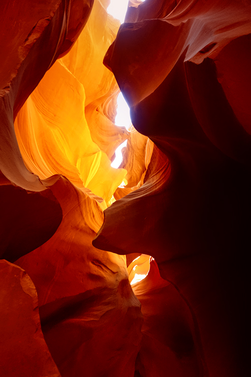
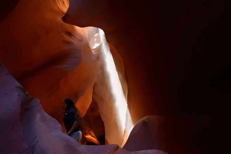
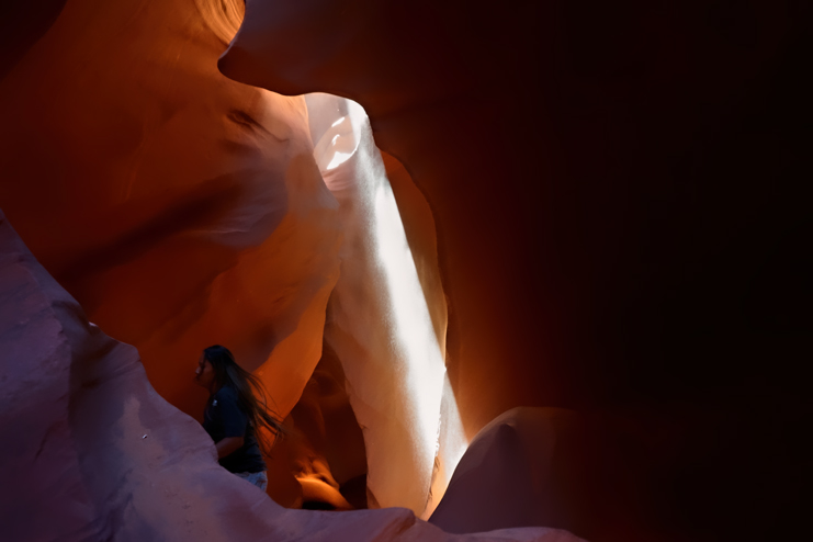
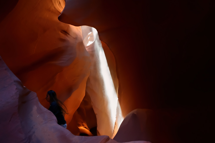
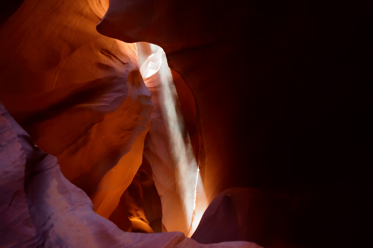
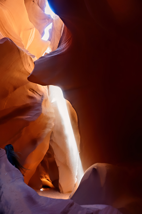
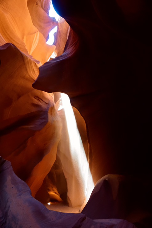
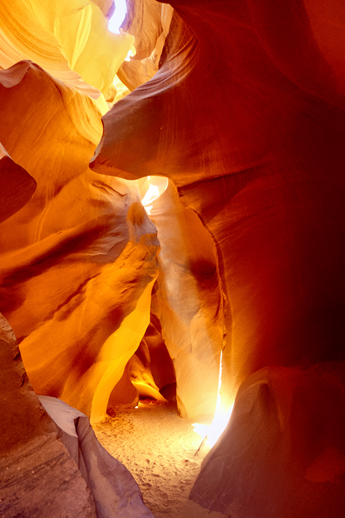
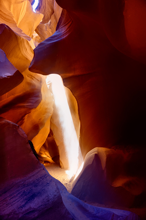
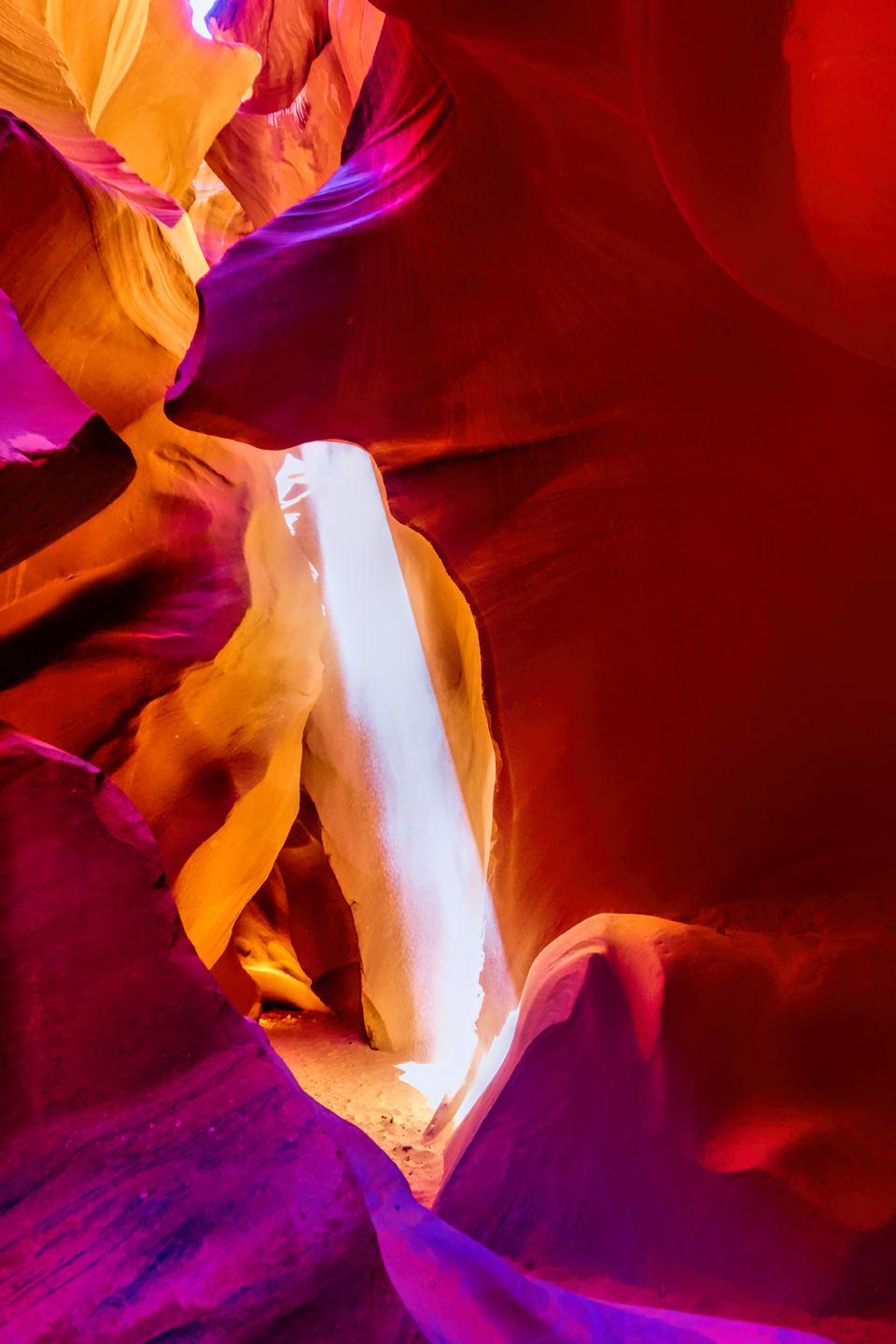
There’s a well-known phenomenon at Antelope Canyon, something that happens regularly in the Spring and Summer, but never in the late Fall or Winter. Ephemeral “God beams” appear like magic in the confined space, slanting across the canyon floor like spotlights on a theater stage, only to disappear after a few minutes as the earth spins another fraction of a degree, breaking the perfect alignment. There’s a common perception that the Upper Canyon is the only place to see the light beams, but that simply isn’t the case. All of the light beam photos in this post were taken at Lower Antelope Canyon.
The second time I visited, in 2015, I drove up from Phoenix in early June, with the specific intention of catching the beams at their peak. My friend and I stopped at the ticket booth a day in advance, and I checked with the tour company, Lower Antelope Canyon Tours (the smaller of the two concessionaires), asking, specifically, about the best time of day for light beams. The gentleman in the booth advised me to go with the photography tour scheduled at 10:20 AM the next morning. “That’s not the best time for colors,” he said. “but it’s the best time for the beams.”
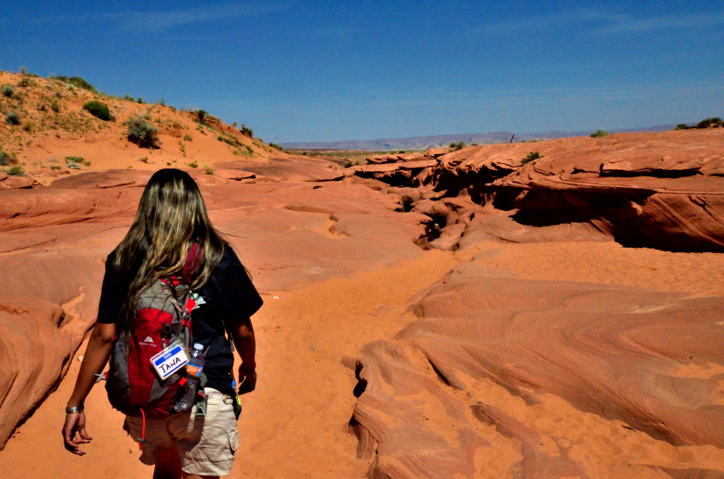
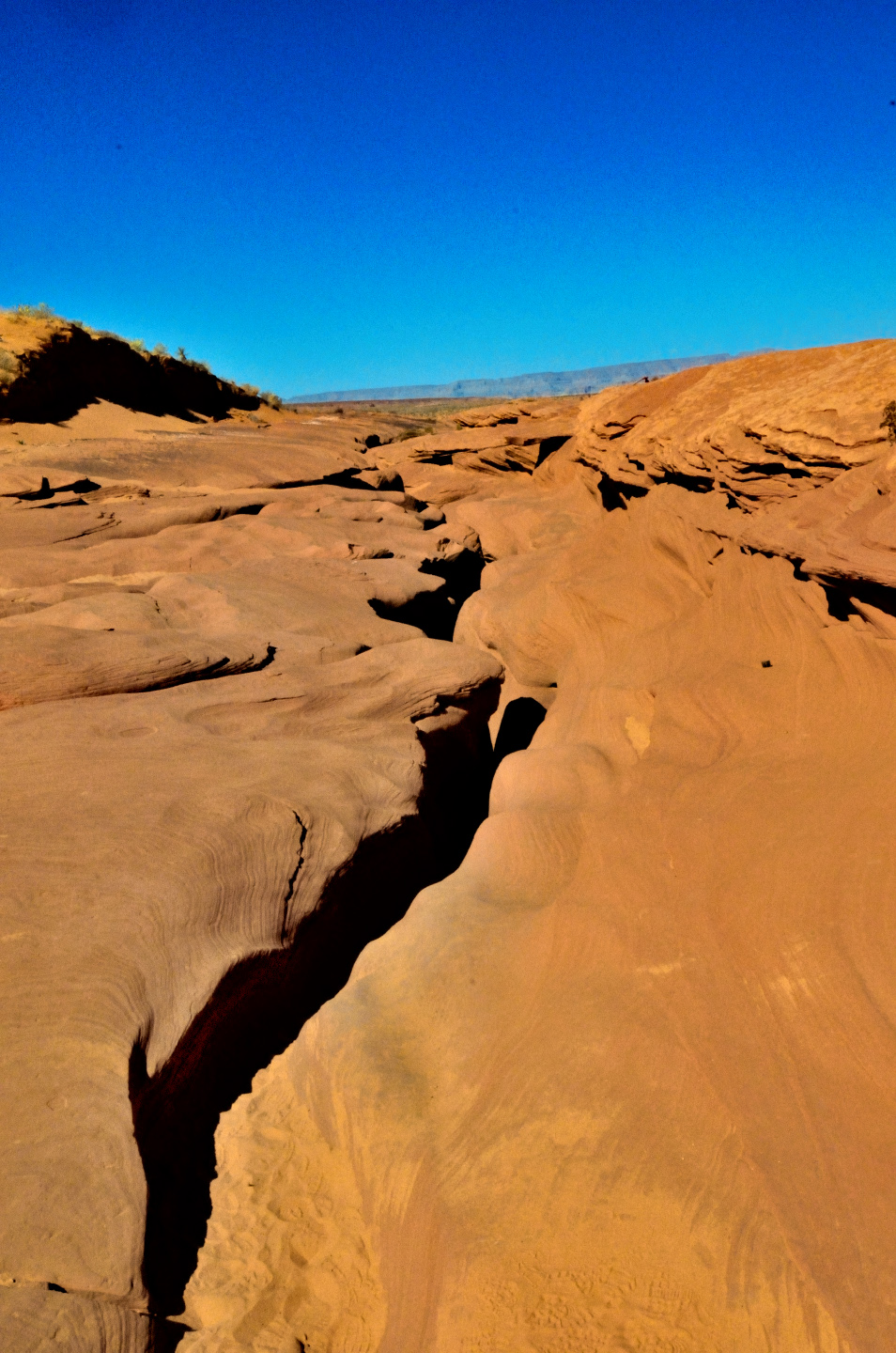
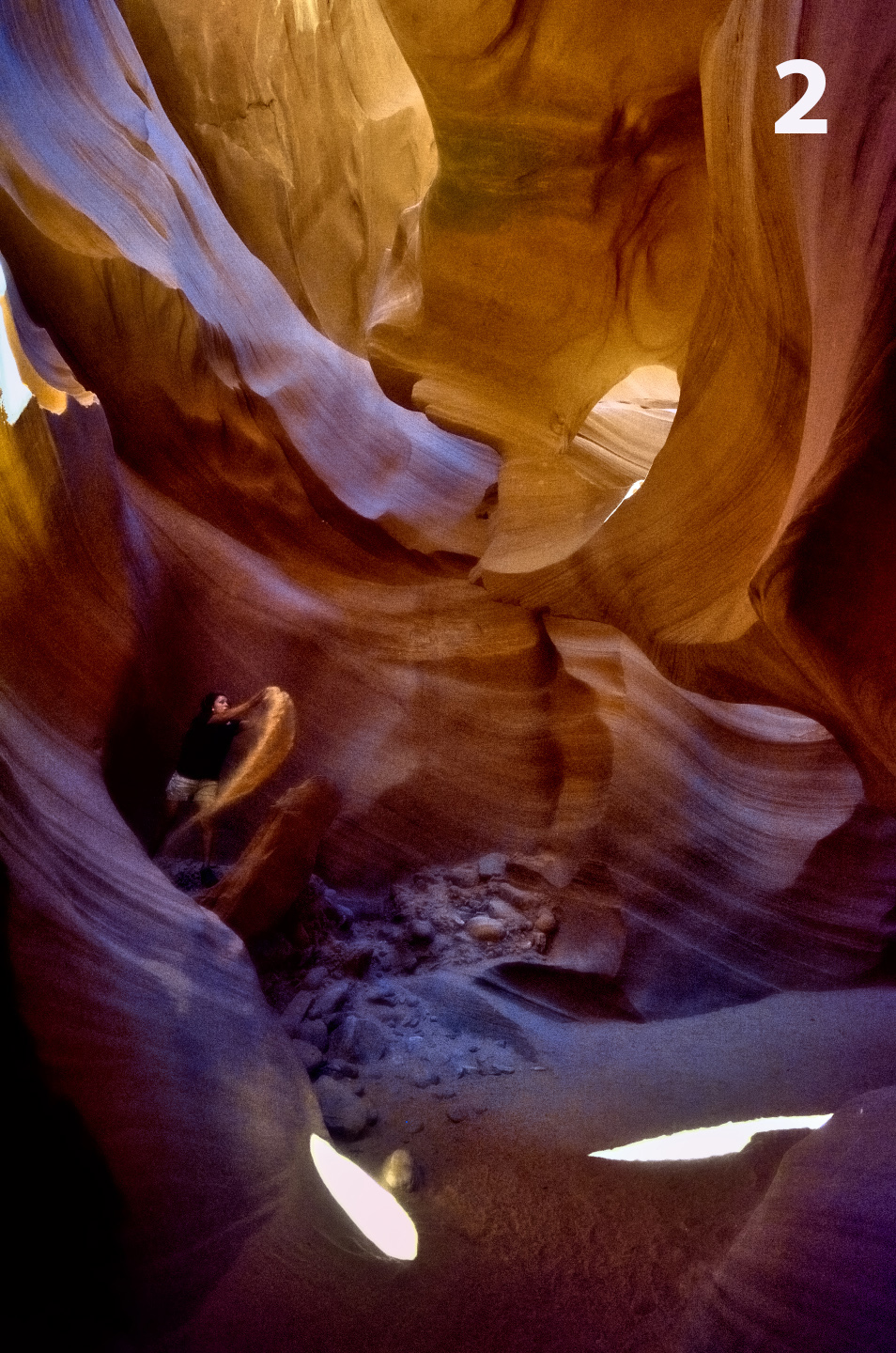
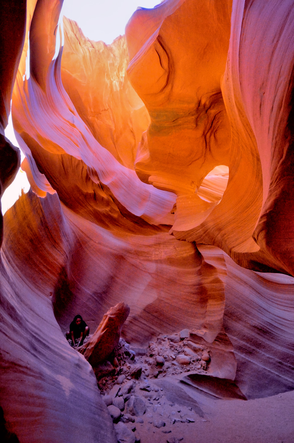
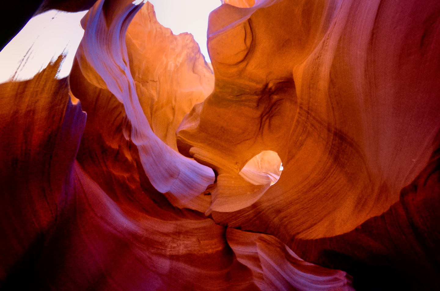
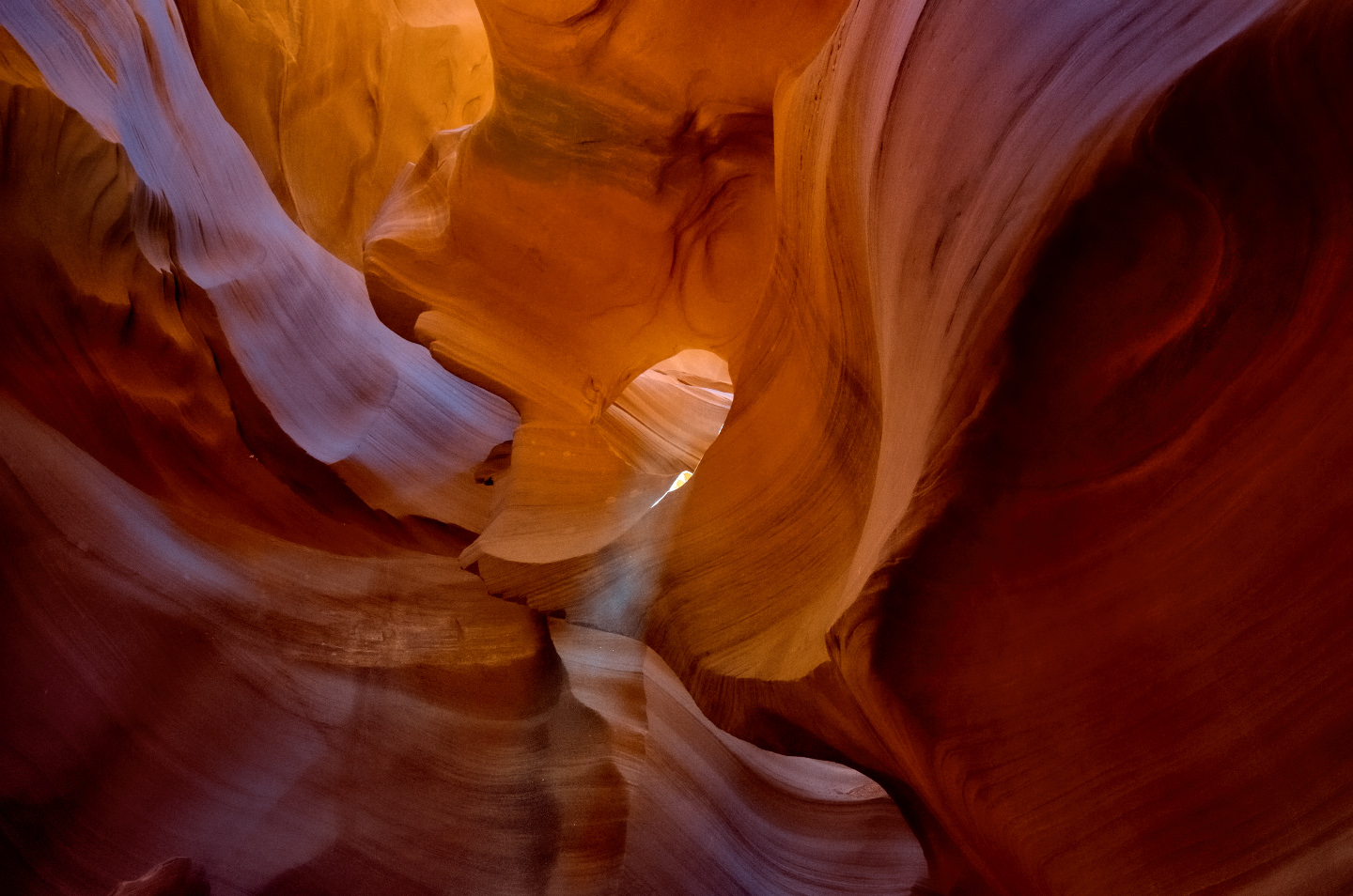
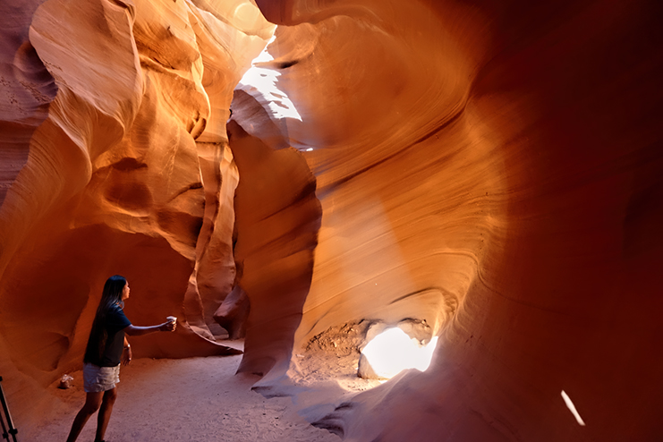
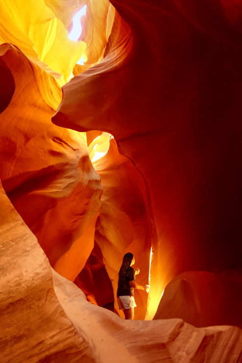
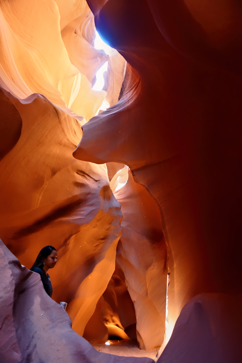
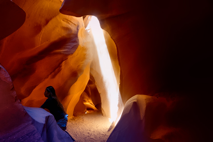
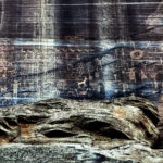
In any slot canyon, but particularly at Lower Antelope, the visual atmosphere can vary dramatically through the course of the day. The top of this canyon is nothing but a fissure in the sandstone that’s as little as a foot wide in some spots, and all the light within the canyon proper comes down through that crack. That same fissure serves as the entrance to Lower Antelope. We followed our guide along a sandy path that led to an opening in the earth, and the first of the metal ladders that took us 75 feet down to the canyon floor.
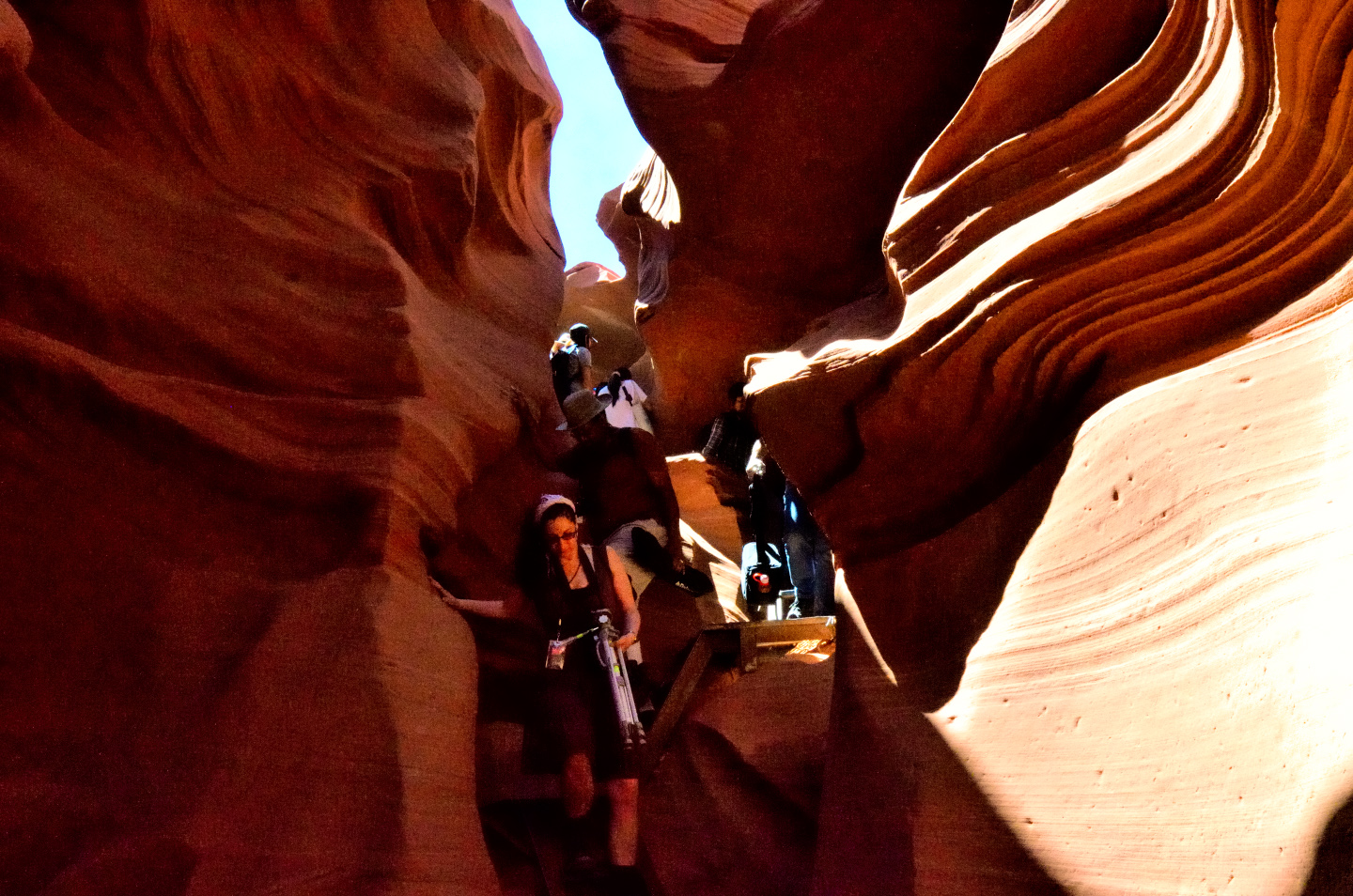
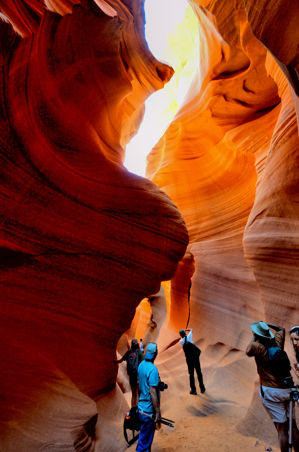
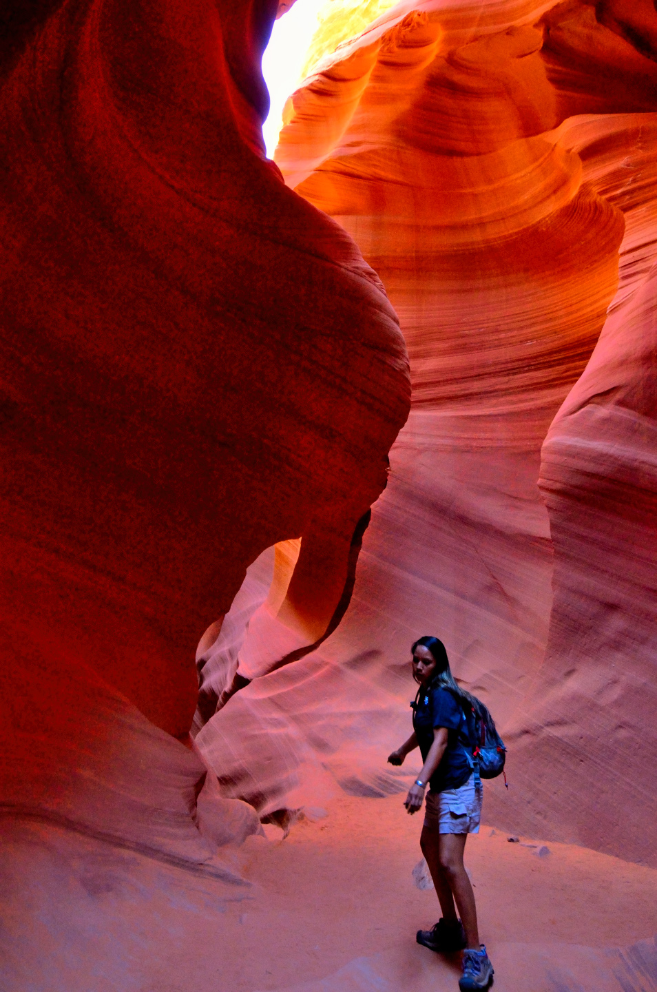
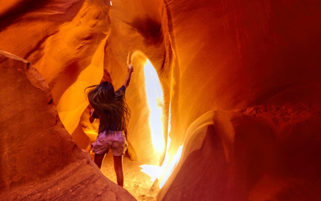
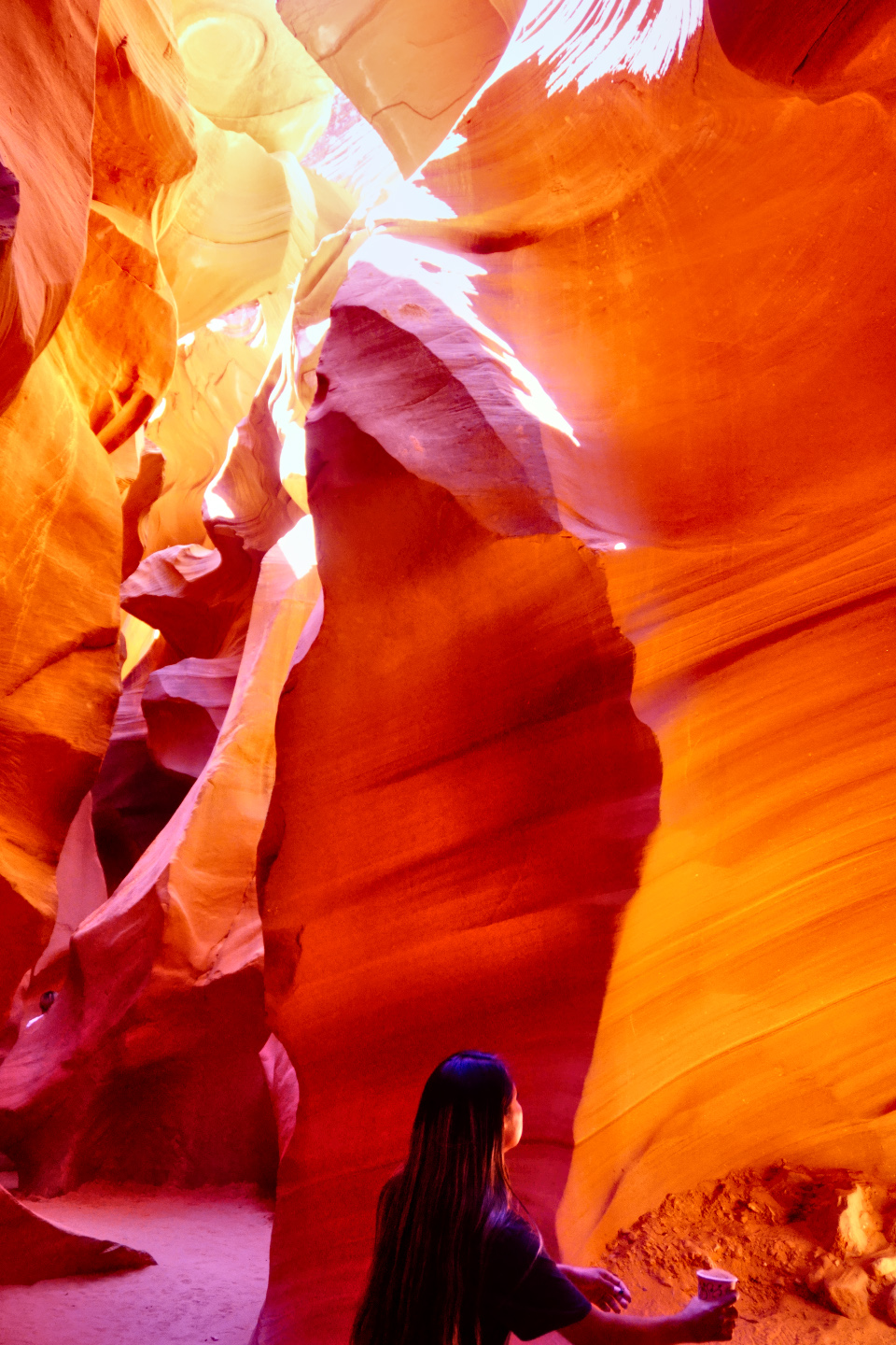
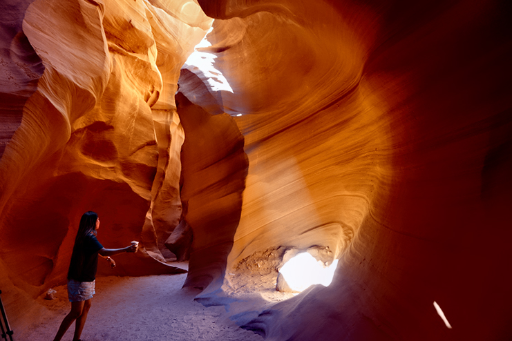
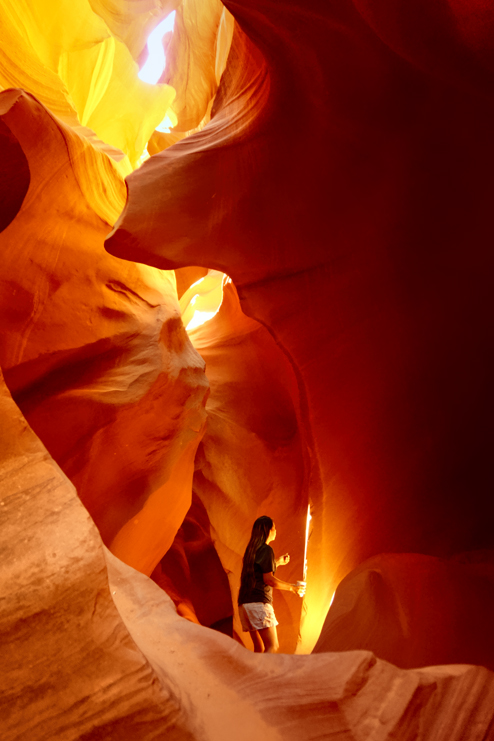
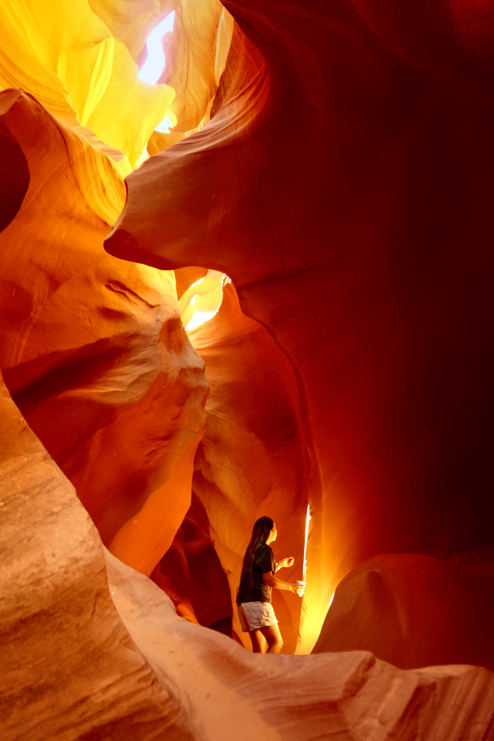
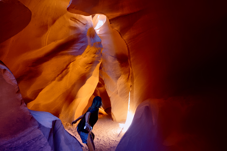
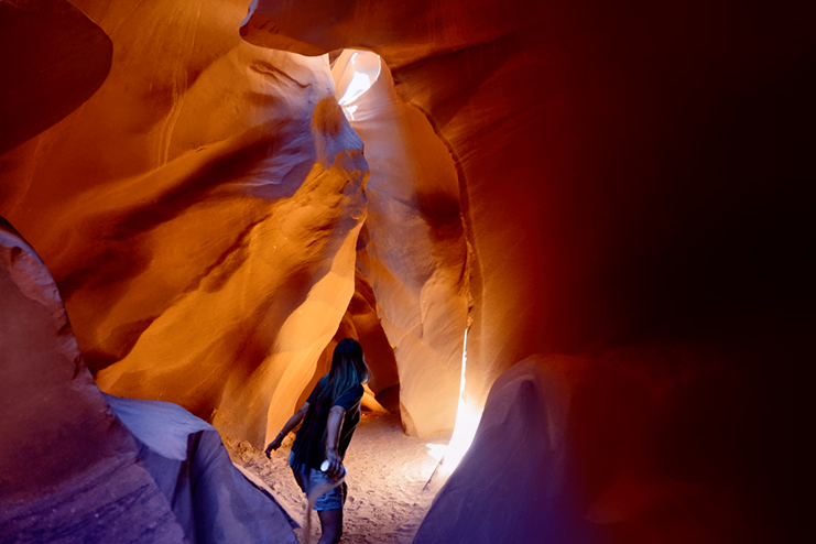
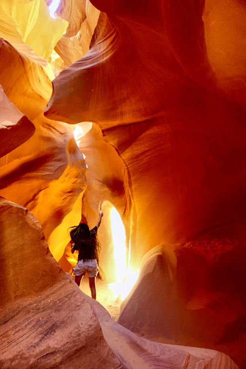
There were a total of six people in our group when we set out that morning, five photographers plus our guide, a young Navajo woman named Quintana Tso. ‘Tana turned out to be a wonderful asset. She was not only familiar with every inch of the canyon, she also knew the best settings for any type of camera, the best way to handle the extreme contrasts, the best shooting angles and spots to set up, and–this was so cool–she had the authority, by mutual agreement among the tour guides, to literally stop any other tour groups from moving through our space while we, the elite, privileged ‘photographers’, finished taking our perfect, distraction-free photographs. What was even more important to me personally: ‘Tana knew exactly where and when those famous beams of light were most likely to appear, and she made sure we were able to take full advantage. Once we were all down the ladders, we followed the path as she led us to a chamber with a high ceiling. There was a glowing band of light filtering down from the top, but there were no beams, at least, not that I could see. As it turned out, I just needed a little patience.

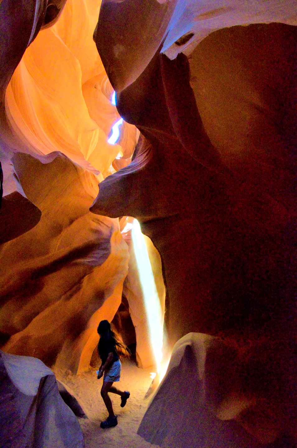
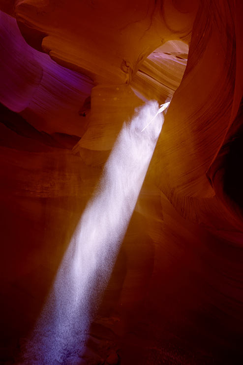
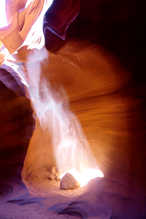
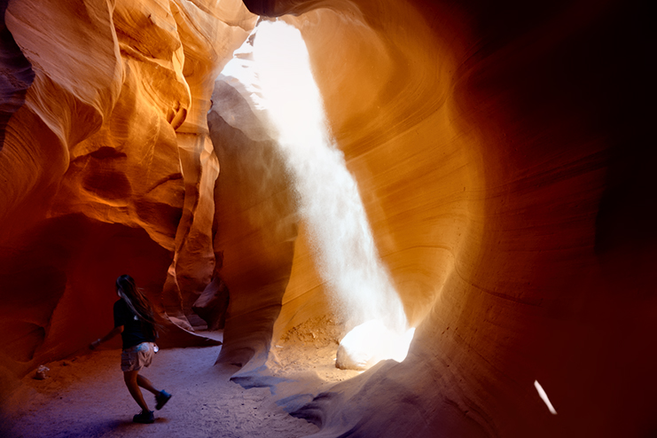
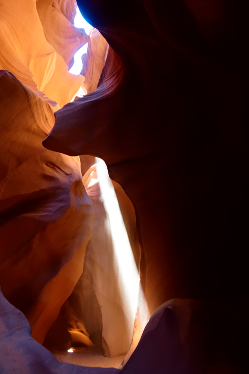
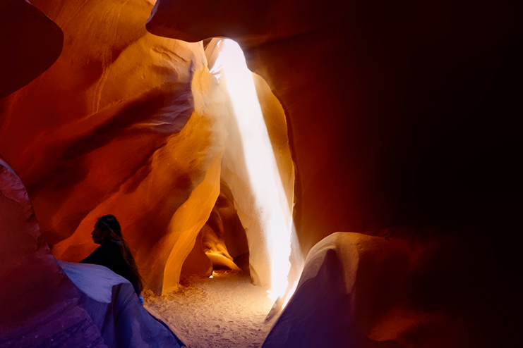
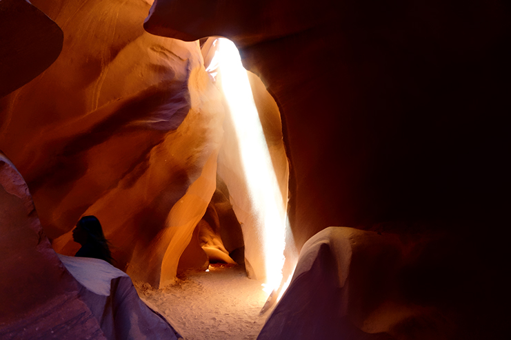
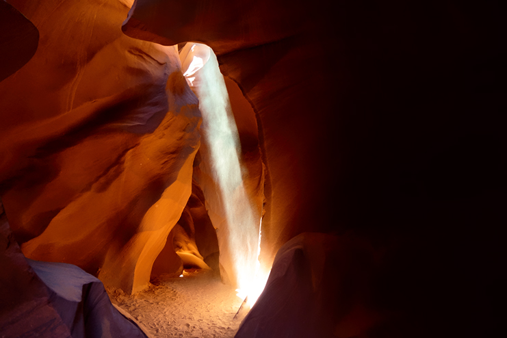
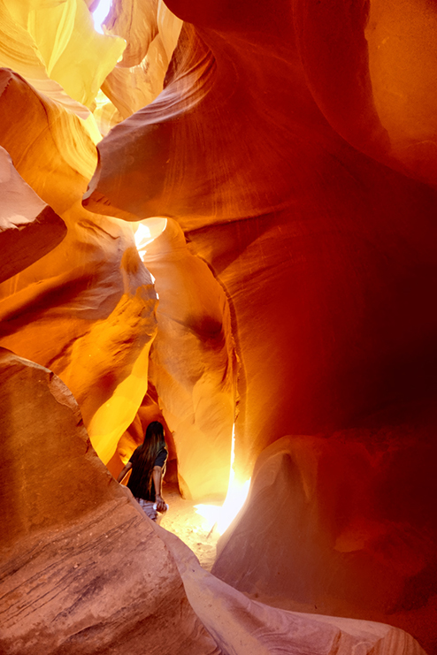
Light beams, or God beams, or crepuscular rays, or whatever you want to call them, won’t show up all that well in a photograph unless there’s something in the air to reflect the light source. The water droplets in fog or scattered rain showers are perfect for this purpose, defining and concentrating those awesome rays you sometimes see in a sunset, or after a storm. The particles in smoke, or in the ash from a volcanic eruption, or dust storms, or heavily polluted air–all of those will likewise serve the purpose, although in a rather more sinister fashion. Since you don’t generally have any of that sort of thing in Antelope Canyon–not the good, or the bad–the guides are forced to employ a bit of trickery to “bring out” the light beams for better pictures. Theirs is a time-tested technique, and pretty simple, though it does take a bit of practice to get it right. All you need is a Dixie cup, liberal quantities of the fine sand that cushions the canyon floor, and a good underhand pitching arm (think, women’s slow-pitch softball). If you’d like to see exactly how that works, check out the slide show (below), and watch as our remarkable Navajo guide ‘conjures’ a beautiful beam of light:
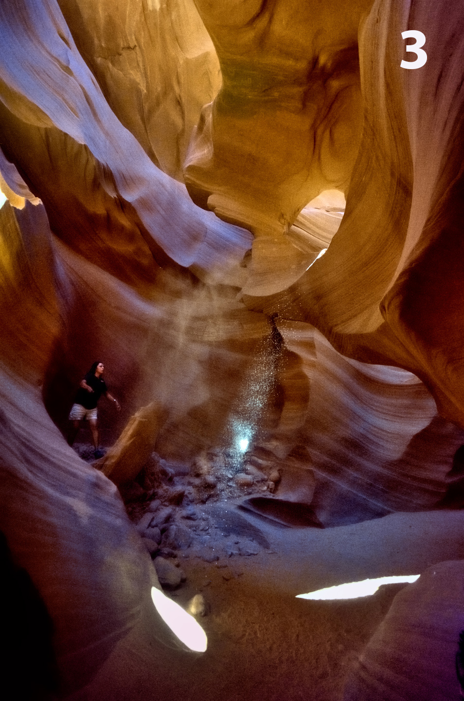
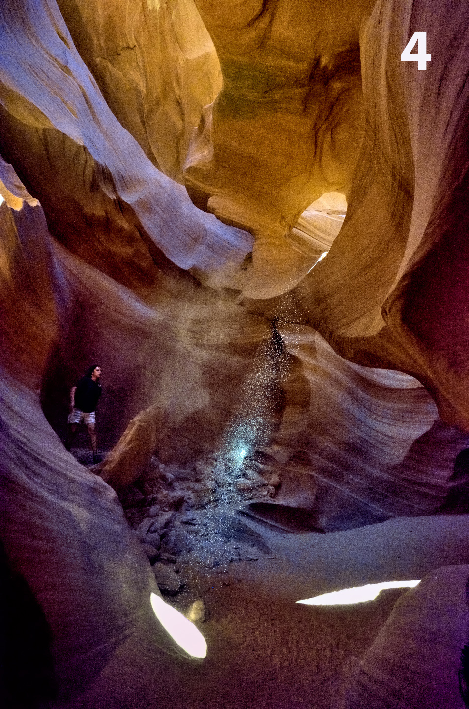
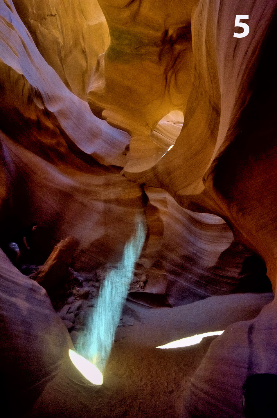
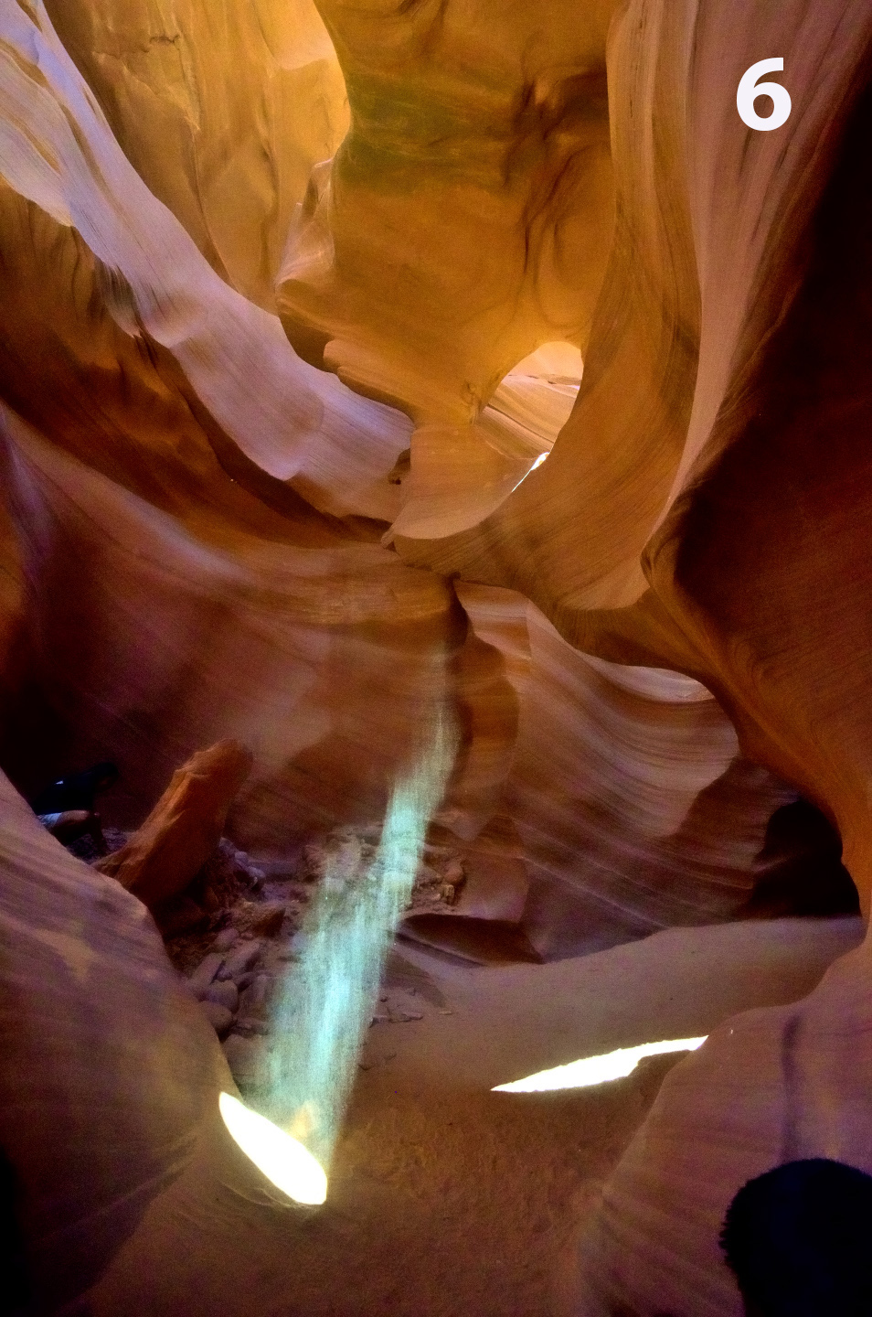
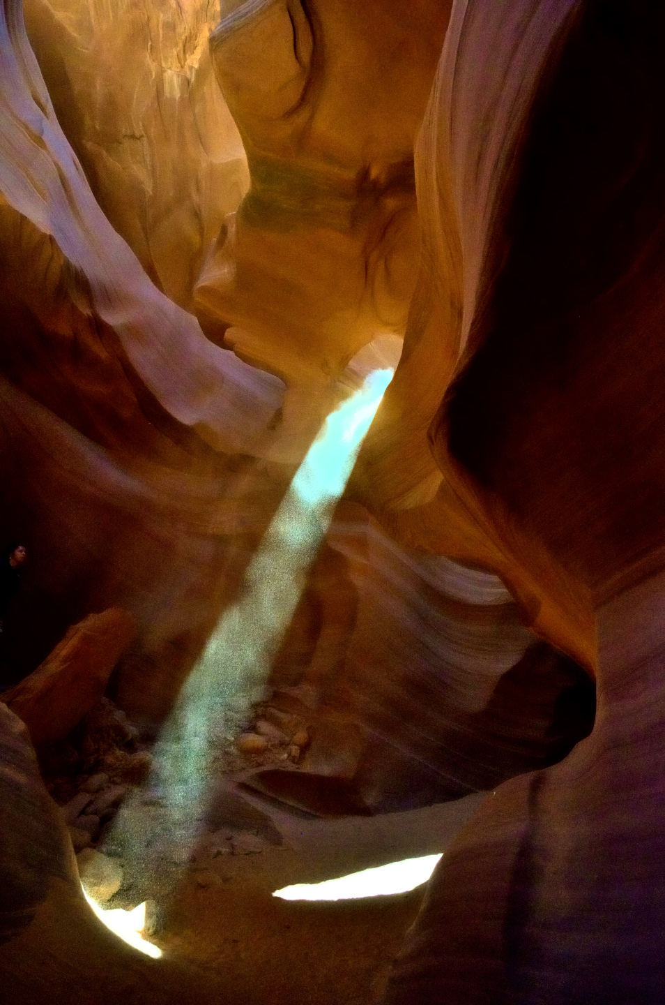
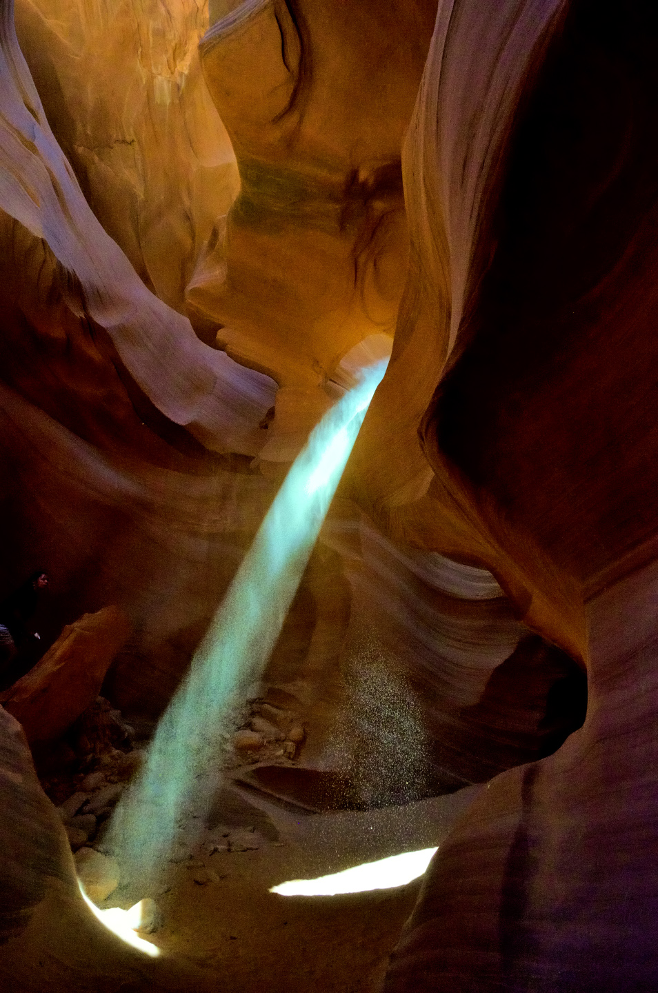
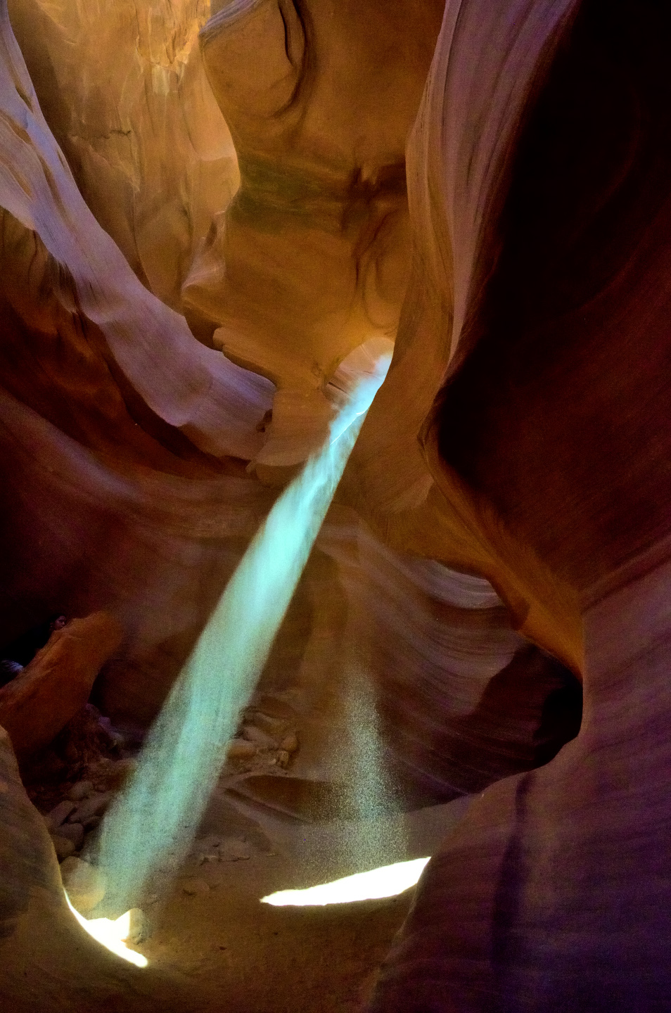
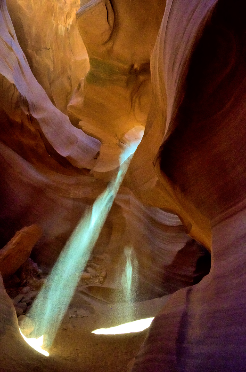
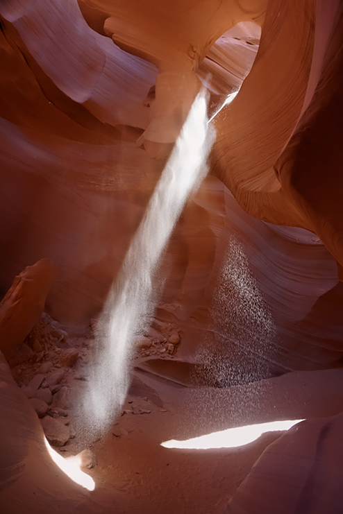
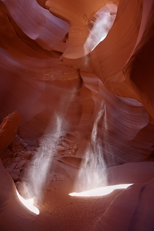
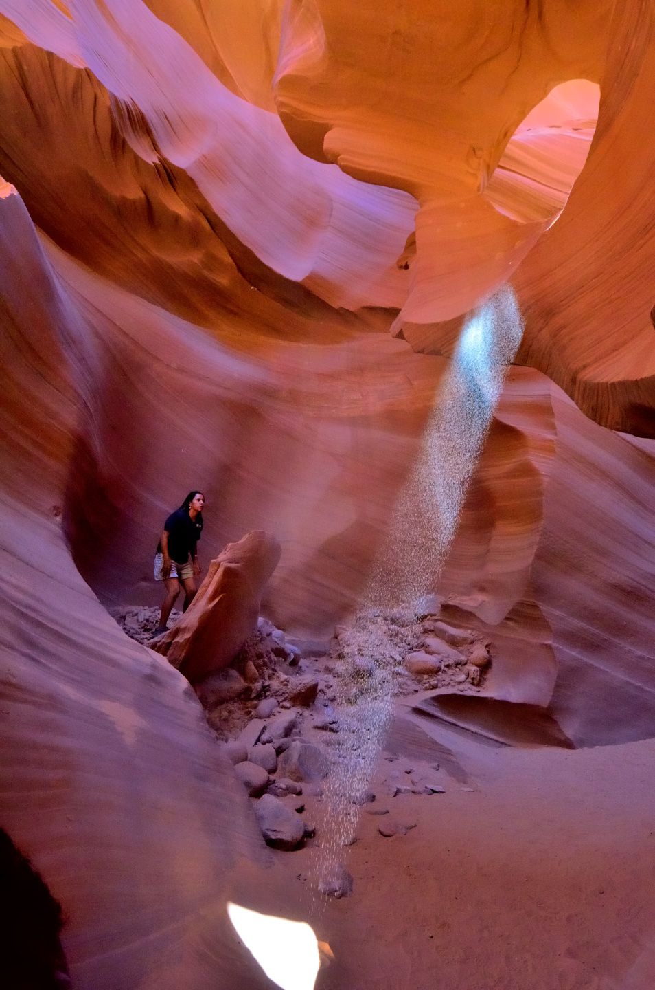
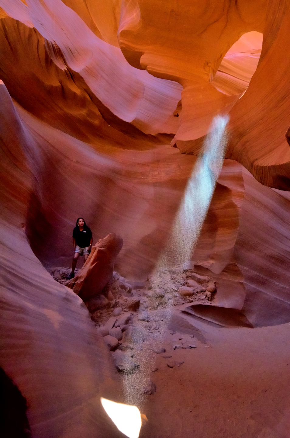
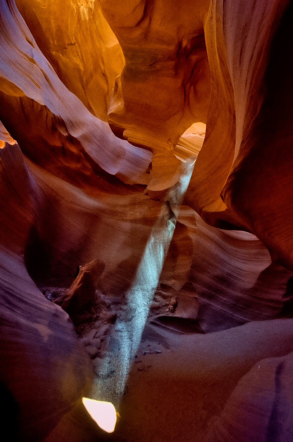
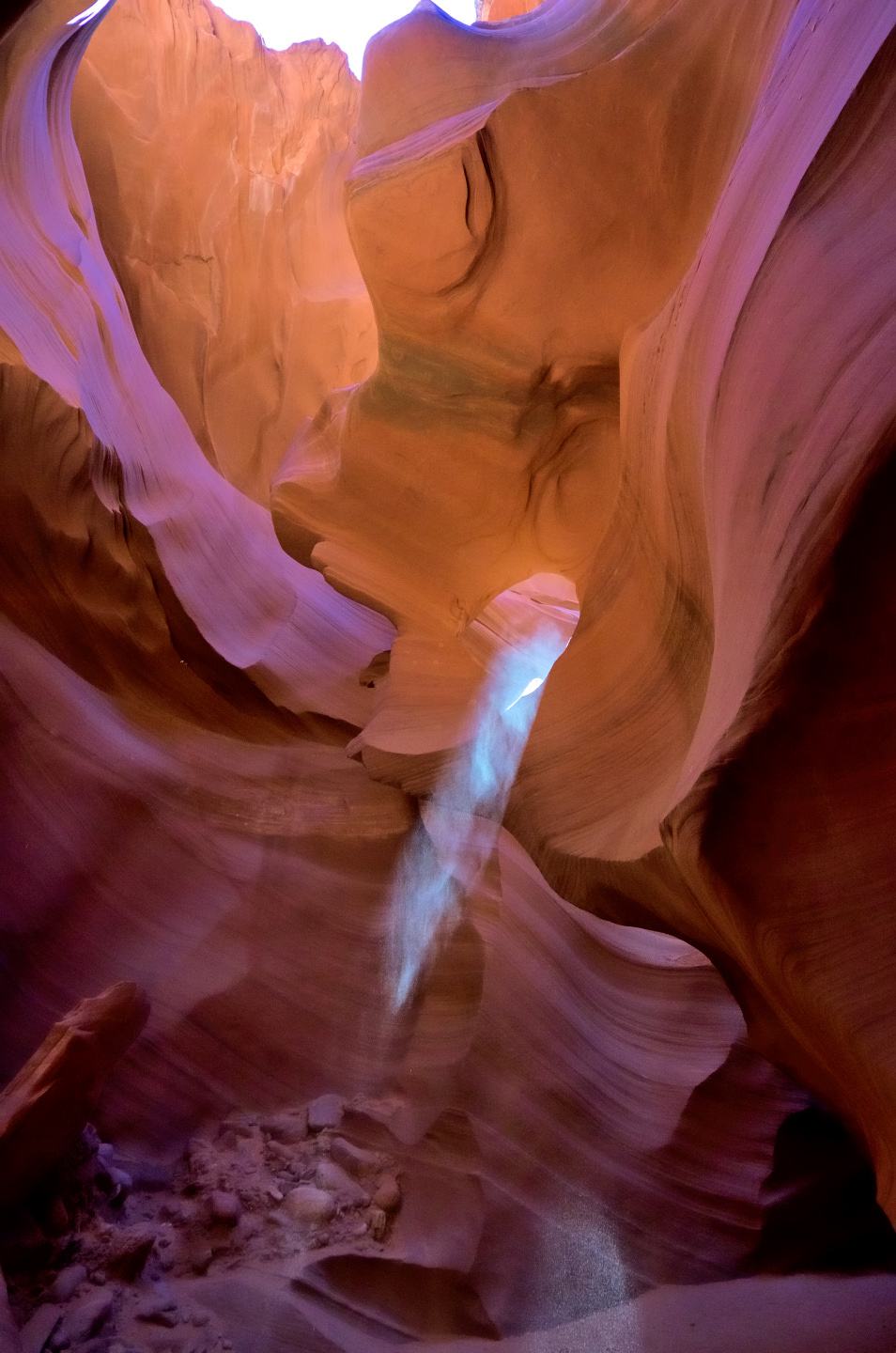

The “fullness” of the light beam is entirely dependent on the quantity of sand that stays suspended in the air. Most of it simply falls to the ground, but the finest particles float for a bit. The shape and texture of the beam ebbs and flows as the floating particles settle.
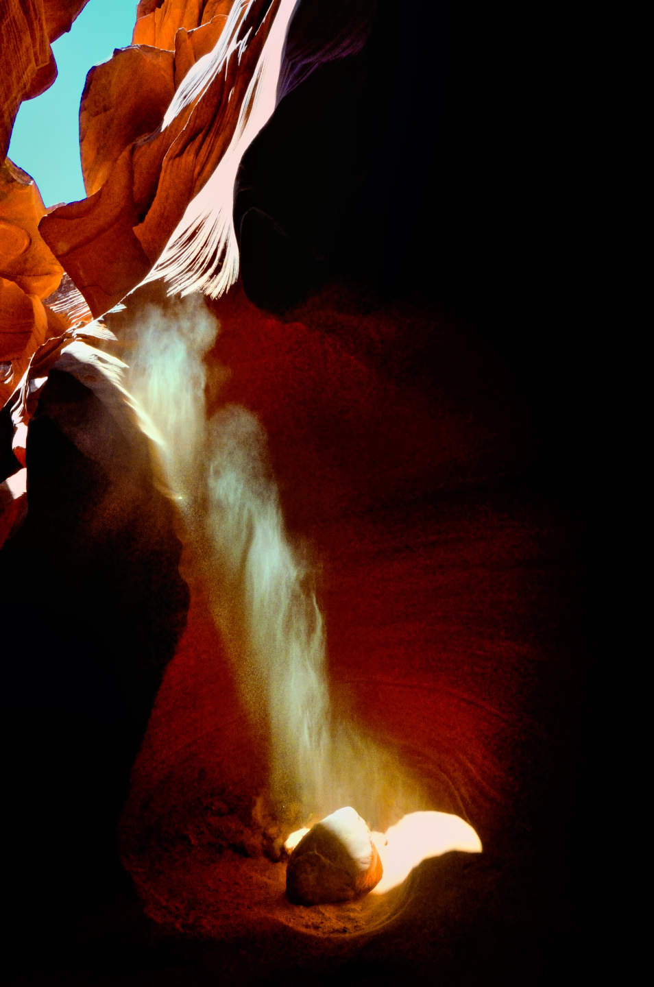
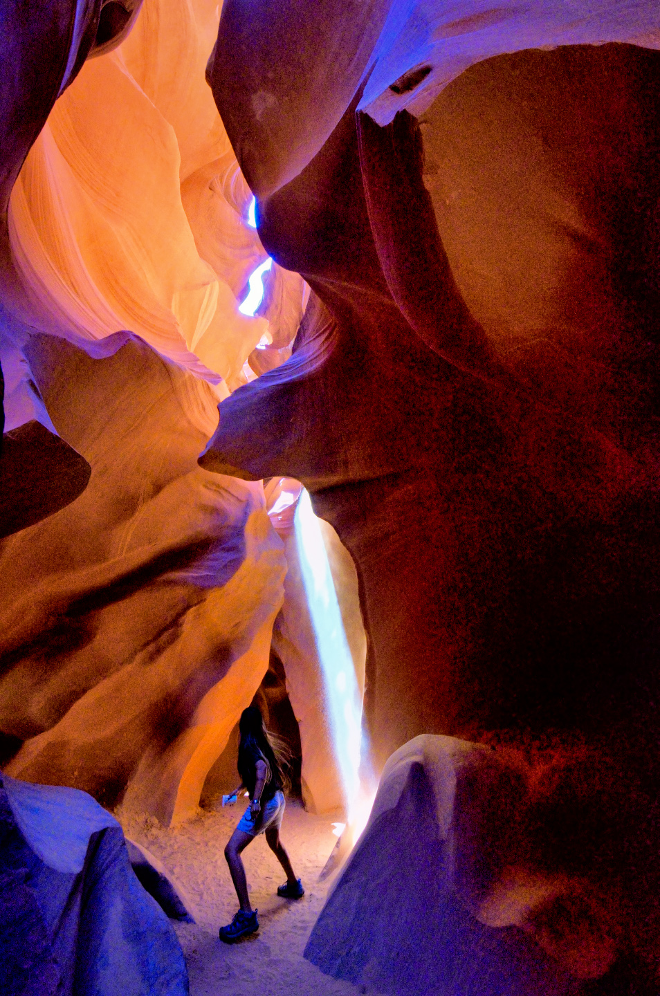
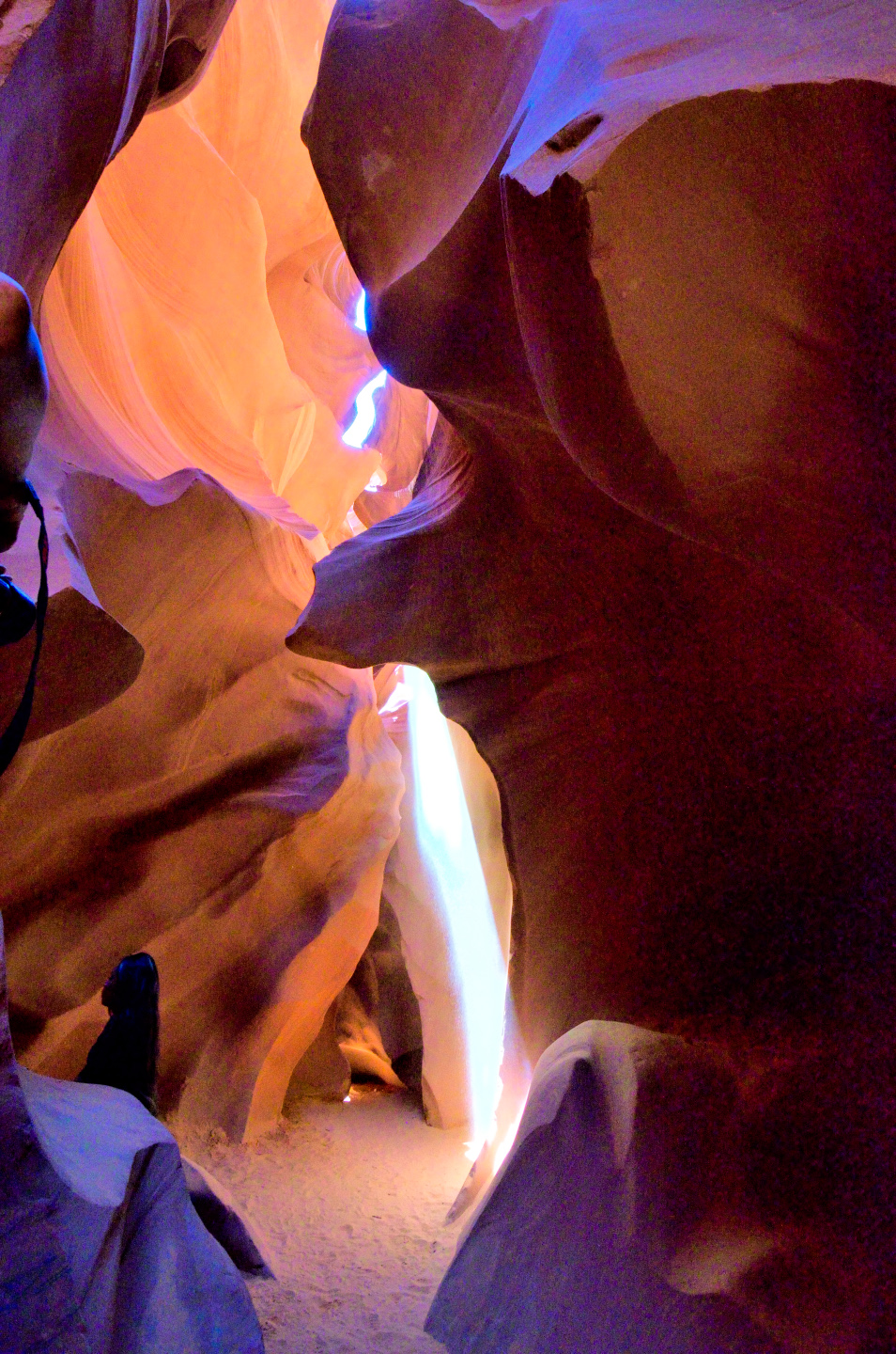
‘Tana was very good about ducking out of the way behind a rock after tossing the sand, so that we could photograph the beam without a person in the frame. Pesonally? I think the pictures with her in them are the most interesting of all!
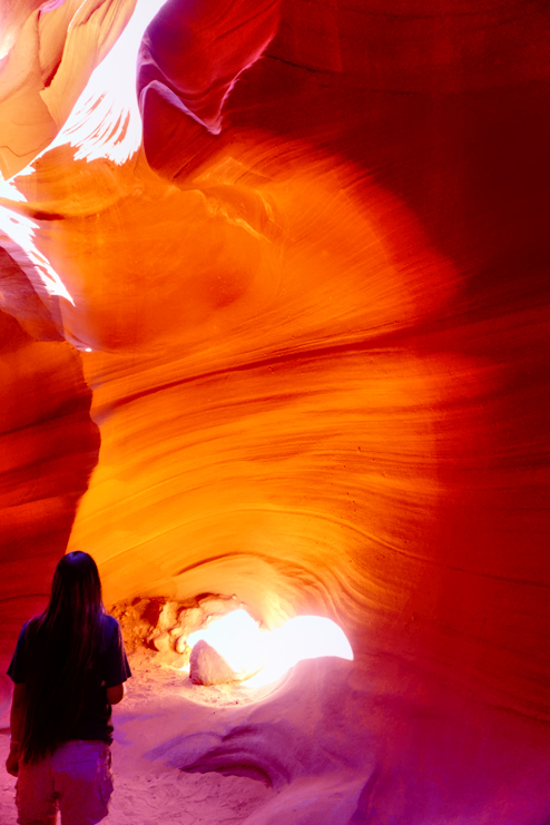
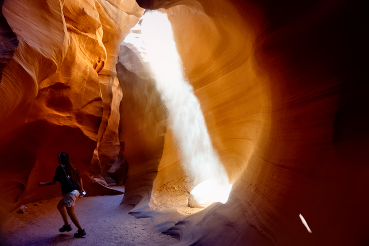


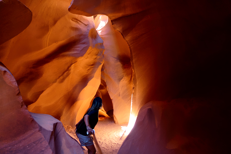
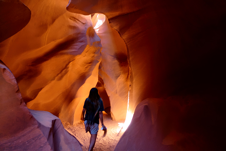
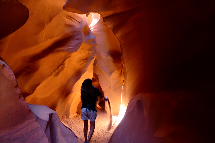
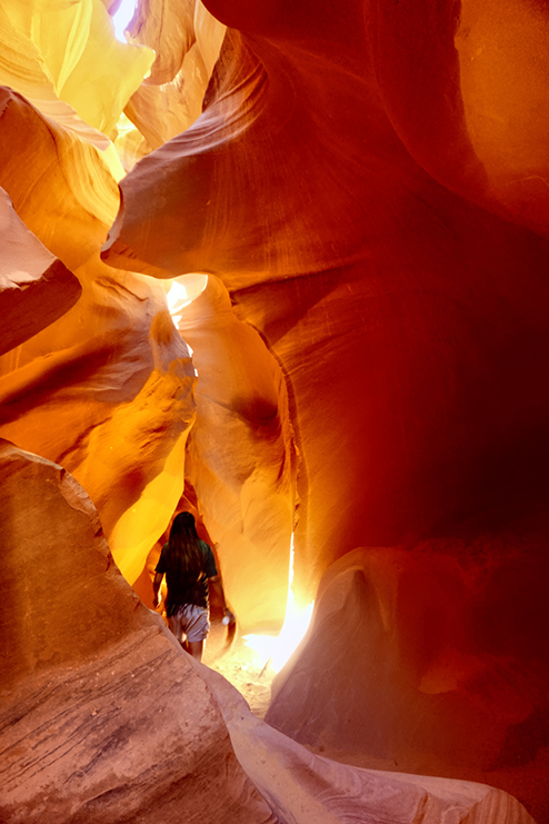
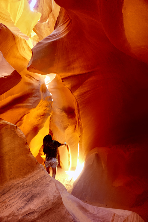
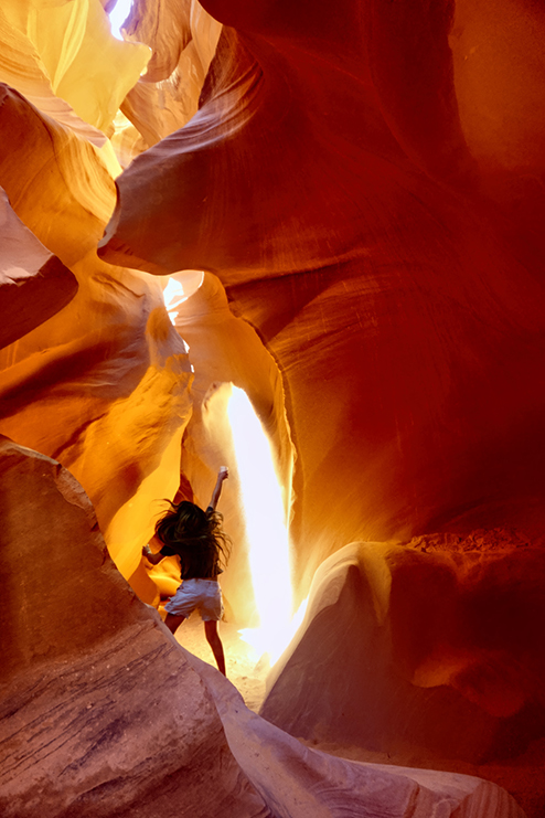
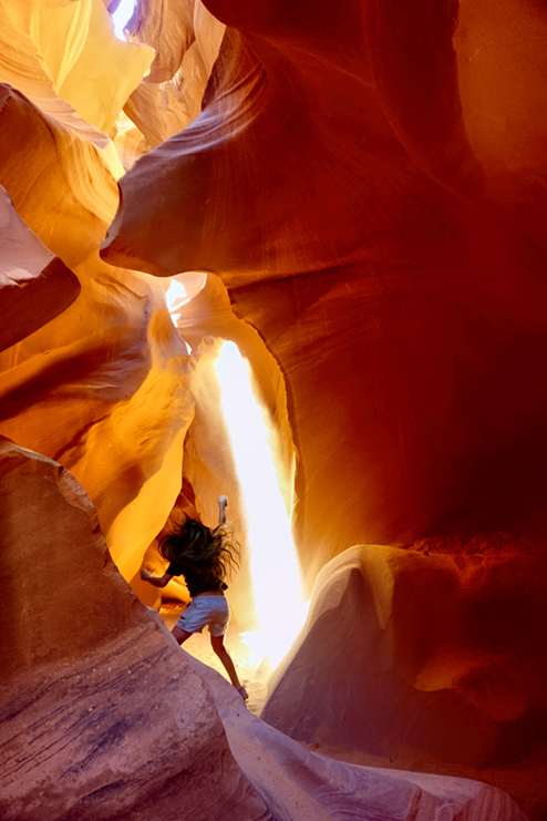
‘Tana’s body language in this sequence of images is dynamic and spirited—she isn’t just tossing sand; she’s performing with wholehearted energy. Her stance, the reach of her arms, her expressive posture, and especially her long hair all convey a sense of vitality and connection to the moment.
You can feel her presence animating the scene—adding a human flourish to the canyon’s natural drama. She essentially becomes part of the spectacle, not simply a guide but an artist helping shape the experience for our small group of photographers. That blend of commitment and grace elevates these photographs, giving them both literal and metaphorical movement. The gesture becomes an act of creation, linking geology and humanity through the luminous arc of sand and light.
The preceding comment is courtesy of Perplexity AI
There’s some debate among serious photographers: is it cheating, to highlight light beams this way? You are, after all, manipulating the environment for the sake of a photo. Under most circumstances, that would NOT be okay, but consider this: in 2014, a black and white photograph of a light beam at Upper Antelope Canyon, taken by Australian photographer Peter Lik, sold for 6.5 MILLION DOLLARS, which was, at that time, the highest price ever paid for ANY photograph. There was a lot of controversy surrounding the sale to an anonymous buyer, and questions about the level of “post-processing” (manipulation with imaging software) that may have been done to create the print.
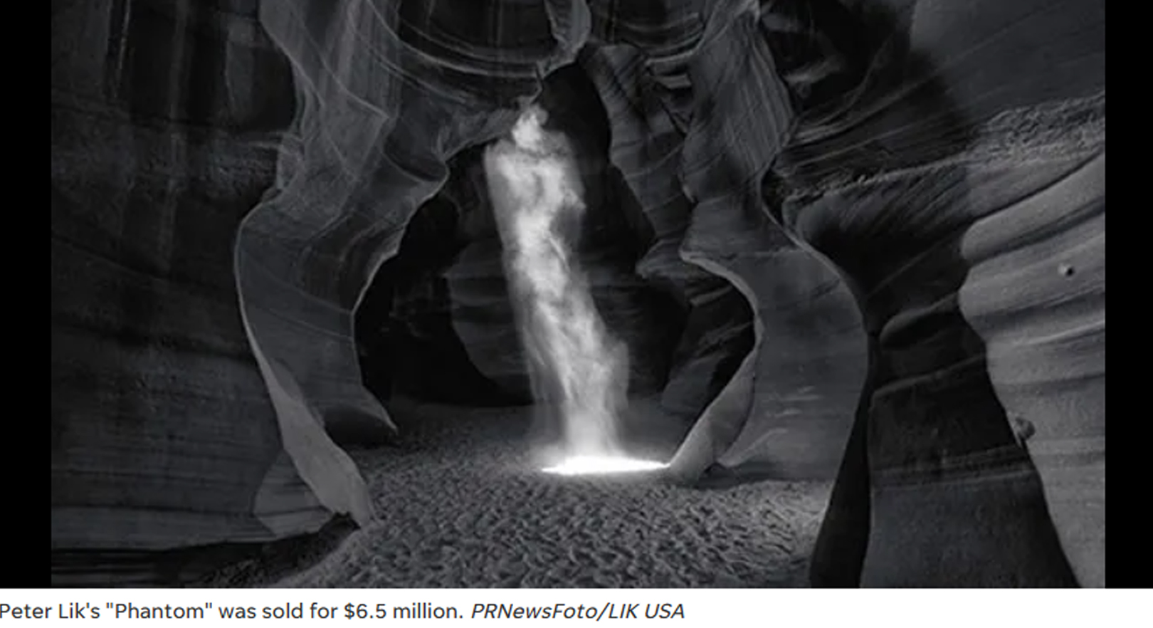
No one questioned the authenticity of the light beam itself, which was almost certainly the product of a dixie cup full of sand!
(Unless otherwise noted, all of these images are my original work, and are protected by copyright. They may not be duplicated for commercial purposes. My own use of these photos is authorized by an after-the-fact permit obtained from the Navajo Tribe. It’s important to note that such permits, even though they are technically required for any photos of Antelope Canyon that are published, are no longer obtainable due to an overwhelming volume of such requests. Once again, being an old guy has it’s advantages. I got in there before they closed and locked the door.)
This is an interactive Table of Contents. Click the pictures to open the pages.
The Incomparable Beauty of Antelope Canyon

Antelope Canyon: Where Water Runs Through Rocks
Torrents of rainwater borne from the monsoon storms of summer sluice through channels and cracks in the soft sandstone of the Plateau. Powerful floods strike repeatedly, year after year, ultimately carving narrow, twisting pathways into the cross-bedded layers of rock, sculpting it into swirling formations that look like petrified waves.
<<CLICK to Read More!>>

Conjuring a Beam of Light in Antelope Canyon
Ephemeral “God beams” appear like magic in the confined space, slanting across the canyon floor like spotlights on a theater stage, only to disappear after a few minutes as the earth spins another fraction of a degree, breaking the perfect alignment.
<<CLICK to Read More!>>
MORE SOUTHWESTERN ROAD TRIPS:

San Xavier del Bac: The White Dove of the Desert
San Xavier has all of the traditional elements of a Spanish Colonial church, along with many others that are quite unique. The craftsmanship of the original building is superb, and features many fascinating details.
<<CLICK to Read More!>>

A Serendipitous Sunset at Shiprock
I noticed an odd rock formation coming up fast on the left side of the road, almost like a wall built of angular blocks. Shiprock was close, but hidden from view by the wall as I zoomed toward it. After I passed the odd formation, I stole a quick glance in my rearview mirror, and what I saw was a scene so other-wordly, it literally stopped me in my tracks!
<<CLICK to Read More!>>

A Sunset at White Sands
Dropping down out of the Sacramento Mountains near Alamogordo, the sky was filled with the colors of the widest rainbow I’ve ever seen. Down on the flat, another rainbow came spearing down through the clouds before setting out in pursuit of a downpour, off in the middle distance.

New Mexico's Golden Autumn
When you think of autumn foliage, the list of places that comes to mind is much more likely to include New England than New Mexico--but the Land of Enchantment is full of fall surprises!

There’s nothing like a good road trip. Whether you’re flying solo or with your family, on a motorcycle or in an RV, across your state or across the country, the important thing is that you’re out there, away from your town, your work, your routine, meeting new people, seeing new sights, building the best kind of memories while living your life to the fullest.
Are you a veteran road tripper who loves grand vistas, or someone who’s never done it, but would love to try? Either way, you should consider making the Southwestern U.S. the scene of your own next adventure.
A few years ago I wrote a book about road trips in Arizona and New Mexico that’s a lot like this website, packed with interesting information, and illustrated with beautiful photographs. Check it out! You can find it on Amazon, and at all other major booksellers.

The Most Beautiful Place on Earth:
A Guide to Canyon de Chelly National Monument
This is an interactive Table of Contents. Click the pictures to open the pages.
Canyon de Chelly: Part 1: The Rim Drives

Most of Canyon de Chelly can only be seen by visitors who are accompanied by an authorized guide, but the Rim Drives are free of charge, no reservation required. Two roads, Indian Route 7, and Indian Route 64 diverge at the entrance to Canyon de Chelly National Monument. Route 7 follows the South Rim of the multi-pronged formation, providing access to seven overlooks, all with killer views into Canyon de Chelly. Route 64 follows the North Rim, and provides access to three more overlooks, with excellent views into the branch known as Canyon del Muerto.
The South Rim drive is a 36 mile round trip, from the Welcome Center to the Spider Rock Overlook and back again, making multiple stops in between. You’ll need a couple of hours to do it justice, depending on how much time you spend at each of the different overlooks. The North Rim drive is shorter, just over 26 miles round trip to the Mummy Cave Overlook. That drive requires another hour and a half, bare minimum, so if you’re going to do both, you should play it safe, and set aside half a day. I can guarantee you’ll consider it time well spent! <<CLICK to Read More!>>

The South Rim Drive
Indian Route 7 begins at the turnoff from US 190, and serves as the main road in the Navajo town of Chinle. If you follow it headed east, it will take you directly to the Visitor Center for the Canyon de Chelly National Monument. Stop there to pick up a map of the park, and to get current information about guided tours and other activities, as well as road conditions, and any closures that might affect your visit.
From the Visitors Center, bear right at the fork to stay on Indian Route 7, the South Rim Drive, and follow the signs to the overlooks.
<<CLICK to Read More!>>

Overlooking the White House
A mile and a half beyond the Junction Overlook you’ll reach the turnoff for the White House Overlook, which is at the end of a half-mile long access road. The White House Overlook has always been one of the most popular. The vantage point offers a fabulous panorama of the Canyon, along with an unobstructed view of the White House, one of the best preserved ruins in the National Monument.
<<CLICK to Read More!>>

The North Rim Drive
Most visitors to Canyon de Chelly National Monument focus the bulk of their attention on the South Rim Drive, but in my view, your trip simply won’t be complete if you don’t take in the North Rim Drive as well.
Seven miles from the Welcome Center is the turnoff to the Antelope House Overlook, which is two miles further along a paved access road. The payoff is a fabulous bird’s-eye view of a quite wonderful Anasazi ruin known as the Antelope House. You can still see the crumbling foundations of dozens of rooms, a tower, and at least four circular kivas…
<<CLICK to Read More!>>
Canyon de Chelly: Part 2: Chinle Wash

Canyon de Chelly National Monument is a place for the whole world to enjoy and admire, just like all of our national parks and monuments, but at Canyon de Chelly there is an essential difference: the rim drives and most of the overlooks offering views into the beautiful canyon are open to the public all year around. The canyon itself, including all hiking trails and Jeep tracks, all the ruins and the rock art, in essence, anything below the canyon rim, all of that is private property, off limits to everyone save the handful of Navajo families who own the land on the canyon floor.
The rest of us can go in, but only to certain areas, and only if we’re accompanied by an authorized guide. A Navajo guide can take you into the canyon in their SUV, or, if you prefer, you can join a guided hike, or a trail ride on horseback. The standard Jeep tours, which are the most popular, range from three to six hours in length. The longer tours cover the highlights of both of the primary gorges, Canyon De Chelly, and Canyon del Muerto.
The series that follows is a detailed account of my own experience in this remarkable place. <<CLICK to Read More!>>

A Timeless Journey into the Heart of the Navajo Nation
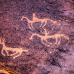
At the beginning of our trip, we asked Sylvia to show us her favorite petroglyphs, along with the usual ruins and rock formations, and she did not disappoint. Our first stop, very near the mouth of the canyon was a prehistoric bulletin board she called Newspaper Rock. A smooth segment of cliff face coated with dark desert varnish, featuring an area at least forty feet wide filled hundreds of petroglyphs. The symbols weren’t carved into the rock, and they are not painted. These artists pecked away the dark varnish, creating their pictures by exposing the lighter colored rock underneath: antelope, birds, hunters, and a multitude of intriguing symbols.
<<CLICK to Read More!>>

Ancient Stories Etched in Stone
A short distance from Newspaper Rock, just a few steps away along the base of the cliff, we came to another set of petroglyphs featuring riders on horseback. These were most certainly Navajo, and likely date back to the 1800’s. They shared this shady space with other images that were obviously much older. There were hunters, deer, birds, handprints, and more. We crowded in close for a better look.
<<CLICK to Read More!>>

Kokopelli and the Lightning Spear
“When you look at this, there’s a man holding a staff; out of the staff there’s this energy that’s coming out. The figure in black is the patient. The one in yellow is the shaman. The important men of the village are up on the side here, so this was a very sacred ceremony that they were doing. And there are some other drawings on the side; this one here is like a figure of the holy people, because it’s way up there, and it only has the head, and not the arms or the legs. You see a lot of people drawn, and there’s a bird there. And these are drawings of, like, clan systems. The bear, the turtle, and the antelope down here.”
I was probably getting a bit starry-eyed at that point. Barely three miles into the canyon, we’d traveled a thousand years in just under a hundred minutes, and we were barely even underway!
<<CLICK to Read More!>>

Where Canyons Collide
Just around the bend the canyon opened up into an area wider than any other we’d seen, and right in the middle was a monolithic block of sandstone known as Dog Rock. To the left was the north fork of the canyon, Canyon del Muerto, and to the right, the south fork, Canyon de Chelly itself. The cliffs soared at least 200 feet above our heads, and halfway up the sheer face opposite was another alcove filled with crumbling adobe, a site called Junction Ruin. A bit smaller than First Ruin, and a bit less well preserved, this is an Anasazi structure dating to the same approximate era. The ruin is clearly visible from above at the Junction Overlook on the South Rim Drive; it looks a bit different when viewed from below…
<<CLICK to Read More!>>
Canyon de Chelly: Part 3: Canyon del Muerto

The left hand fork is the spectacular work of nature known as Canyon del Muerto. The star attraction of this route is the Mummy Cave Ruin, the largest in the area, built on a ledge between a pair of deep caves, high on the face of a cliff in an extraordinary natural amphitheater. It’s a 24 mile round-trip from the Junction, twelve miles of rough road in each direction, with enough twists and turns to qualify as a carnival ride–along with plenty of mud! Along the way you pass the Ledge Ruin, Antelope House Ruin, Navajo Fortress, and Standing Cow Ruin, along with some extraordinary rock art.
The most popular tours last between 3 and 4 hours. Most of them travel into both canyons, but don’t go all the way to the end of either road. Only the longer tours include Spider Rock or Mummy Cave, and only the all day tours include both. Private tours offer the most flexibility, and in most cases, a more comfortable ride.
<<CLICK to Read More!>>

Ruins and Rock Art
In this pictographic sequence, the Utes are on the left, mounted on horseback, with shields and lances, while the Navajos are on the right, on foot, and clearly outnumbered. In one version of the story, just as in Sylvia’s account, the attack took place during a Night Way healing ceremony, in the winter, catching the Navajo by surprise, and at a deadly disadvantage.
The drawings are charcoal, except for the shields, which were painted with pigment made from the bee weed plant. The sandstone overhang provides some protection, but after 150 years or more, the panel is weathering, starting to fade and flake away. Many of the rock art panels in these canyons are in danger of irreversible deterioration from exposure to the elements. Pictographs such as these, done with charcoal and other natural pigments, are particularly vulnerable to the ravages of time.
<<CLICK to Read More!>>

Antelope House
Antelope House was formally excavated in the early 1970’s, by archaeologists working with the National Park Service. Each new culture that occupied this site built atop the remains of their predecessors, so as researchers dug into the stratified foundations, they found the pit houses of the Basket Makers at the bottom, and layers of increasingly sophisticated cultural remains, from the Ancestral Pueblo to the Pueblo people, the Hopi, and the Navajo, each of these groups contributing to the timeline of an area that is exceptionally rich in history.
Of all the ruins and other archaeological sites in Canyon de Chelly, Antelope House is the most thoroughly investigated. That’s at least partially due to simple ease of access: unlike most of the ruins in the canyon, all the primary structures at this site are at ground level.
<<CLICK to Read More!>>

Standing Cow: A Home Among the Ruins
The hogan, much newer than the other structures, was built using sandstone bricks recycled from the surrounding ruins. That would never have been allowed today, but at the time, before the National Monument was established, there weren’t any rules against it, so Sylvia’s great grandfather was simply being practical, using what was available. Today, Standing Cow is on all the maps, as much a part of the human landscape of Canyon de Chelly as the White House and the Mummy Cave. We felt quite privileged to be there with someone who was so directly connected to all of it.
<<CLICK to Read More!>>

Blue Bull and Mummy Cave
300 feet above the canyon floor, there are two deep alcoves filled with ruins, and on a wide ledge between them, a large, multi-story pueblo, partially reconstructed, and quite impressive. The setting is a natural amphitheater, and the overall aspect of the place is simply stunning.
Occupied for a thousand years, from around 300 A.D. until 1300 A.D. The whole complex, including the main building and the structures in the two flanking alcoves had as many as 70 rooms, including living quarters, ceremonial spaces, and storage.
<<CLICK to Read More!>>
Canyon de Chelly: Part 4: The Road to Spider Rock

Today, only authorized Navajo owned vehicles are allowed inside Canyon de Chelly, but this was in 2013, when it was still possible to drive yourself in your own 4×4, as long as your Navajo guide rode along with you. That arrangement was Sylvia’s specialty, and driving through that canyon, with her ongoing expert narrative providing background on all the points of interest, was some of the best fun I’ve ever had.
The first part of the route was aleady familiar to me. We entered Chinle Wash from that same dirt road, just past the Visitor’s Center, and I took off down the sandy creek bed, keeping up a steady speed and zig-zagging diagonally across the deepest ruts, to avoid getting trapped.
We passed by all the places where we’d stopped the day before, and made it all the way to the junction in just over half an hour. This time, we took the right hand fork, and we hadn’t gone far when we ran into our first big challenge of the day: a steep downslope that crossed a wash, with deep mud at the bottom of the hill.
<<CLICK to Read More!>>

Riding the Rainbow to the Universe
Viewing Spider Rock from below provides a dramatically different perspective on this extraordinary formation. From above, you’re looking down on the whole tableau, and Spider Rock, shorter than the soaring canyon walls, appears as one small part of the larger scene. From below, from the floor of the canyon looking up at it, you can see just how BIG the danged thing is. At 800 feet in height, it’s a good bit taller than your average 50 story sky scraper, and it completely dominates the landscape.
<<CLICK to Read More!>>

The Oldest White House
At the center of the upper section is a large room, 12 by 20 feet, with a front wall that is 12 feet high and made of stone that is two feet thick. This wall was coated in white plaster, decorated with a yellow band, and it is this white wall, which can still be seen, that inspired the name La Casa Blanca, the White House, to this ancient dwelling that has endured in this place for nearly a thousand years.
<<CLICK to Read More!>>
YOU MIGHT ALSO ENJOY:
ALASKA ROAD TRIP:
MEXICAN ROAD TRIP (IN THE LAND OF THE MAYA):
ARIZONA AND NEW MEXICO:
SOUTH AMERICA:
PHOTOGRAPHY:


0 Comments