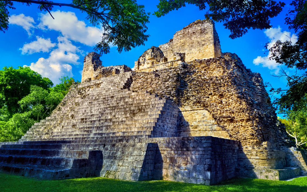
The Rio Bec region includes most of the southeastern portion of the Yucatan, the area where the borders of modern-day Mexico, Belize, and Guatemala all come together. There are a number of important Maya sites in that region, and they share a common suite of distinctive architectural traits, known, collectively, as the Rio Bec Style. The largest and most influential of the Rio Bec kingdoms was Calakmul, located in the southernmost part of what is now the Mexican state of Campeche. Calakmul dominated the lesser cities in its corner of the Maya World, in the same way that Coba dominated its neighbors in the north. They were contemporary with, and peer to, not only Coba, but to Tikal, to Palenque, to Uxmal, to all of the major Mayan centers that reached their peak in the Classic Period. Of all of these famous Mayan archaeological sites, Calakmul is perhaps the least well known, not only to the general public, but to the scientific community as well, largely because of the site’s relative isolation. Until quite recently, there was no passable road anywhere near the place, so those who wanted to go had to hoof it in on foot. And when they got there? So few of the buildings had been cleared, there really wasn’t much to see. All that has changed. The road was finally built, a paved road, no less, and at the site, a number of important buildings have been properly and thoroughly excavated by research teams and are now accessible to visitors. Research at the site has been ongoing for a bit more than 20 years–a painstaking process that continues to produce important finds. It’s still relatively isolated–which helps to keep it relatively unspoiled. You have to travel two hours from the nearest town of any size just to get to the turnoff, and the road south toward the ruins, even though it’s new, is still typical back country Mexico. It’s only 60 km, but that will require at least another hour of driving, complete with topes (killer speed bumps). A bit of touble? Yes, but for any true Maya aficionado, it’s definitely worth the trip. For one thing, Calakmul boasts the largest Mayan pyramid ever built! (Emphasis on Mayan).
Calakmul. Photo from the History Hub
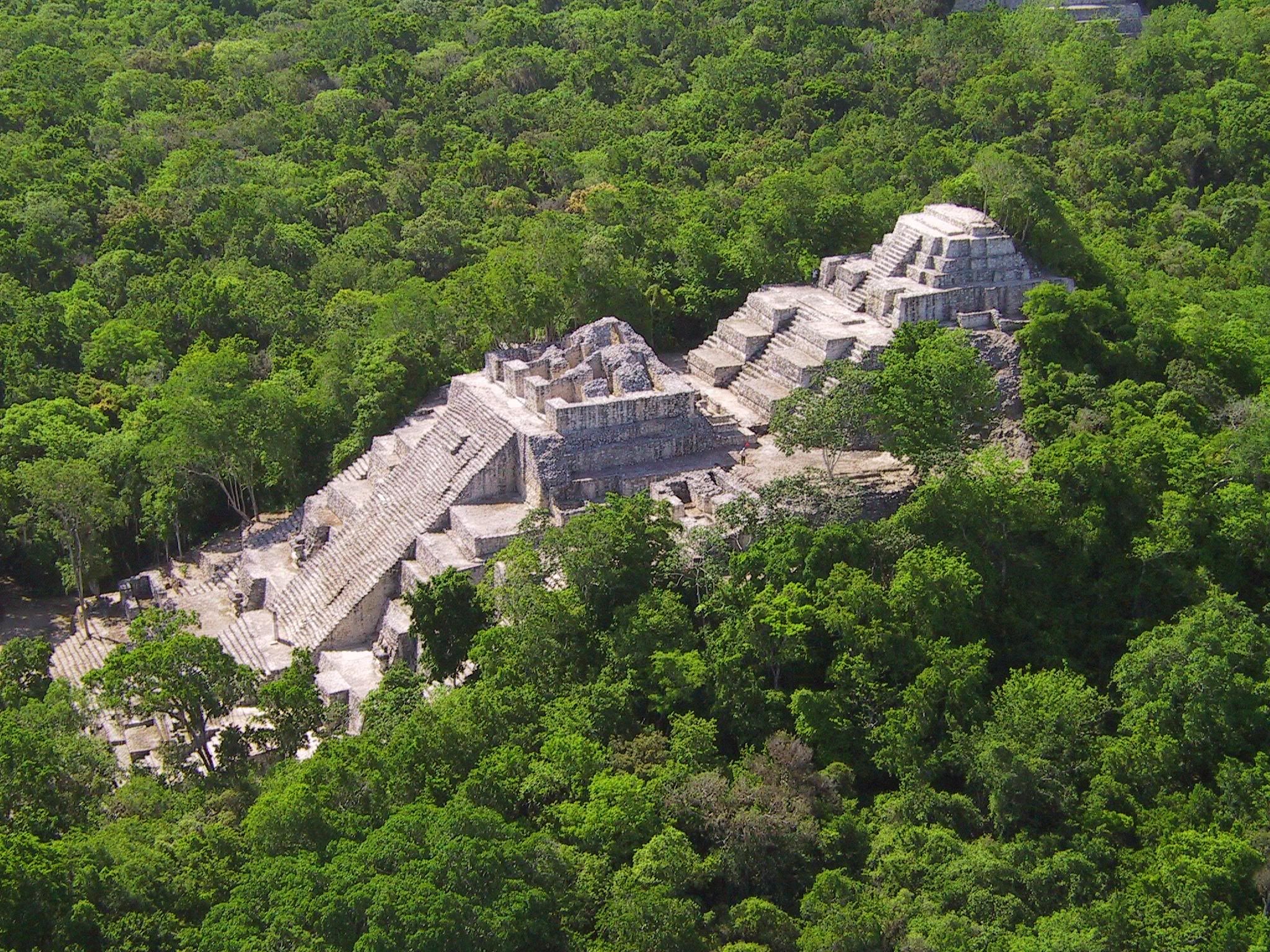
A massive structure that rises up out of the jungle to a height of 148 feet, with a base that’s close to 400 feet on each side? If bigger is better, this thing takes the prize, and the surrounding forest is so thick that it grows back almost as fast as they can chop it away. There are tours available, leaving from Chetumal, in the state of Quintana Roo, as well as from Escarcega, in the state of Campeche, but if you go on your own, in a rental car, for example? You’ll probably have it all to yourself. Visiting Calakmul will give you a taste of what it would have been like to tramp around in any of these major Mayan ruins in the century gone by, before the crowds and the vendors, before the cosmetic restoration and the T-shirts and the faux Mayan curios made in China. 95% of Calakmul remains completely hidden, so you get to look at the overgrown mounds, choked with thick jungle growth, and you get to imagine. There’s nothing quite like that feeling.
However you get to Calakmul, you should allow a minimum of two full days, and, ideally, you should combine it with some of the other Rio Bec sites in the area–keeping in mind that the closest decent lodging is in Chetumal, or Escarcega, neither of which is all that convenient. On my own recent trip to the Yucatan, my time, sadly, was not unlimited, and Calakmul was just a little bit too far out of our way. Looking back, I regret skipping it, so I made a promise to myself: Calakmul is still on my bucket list. One of these days I’ll get back down there, and next time? I’ll take the time.
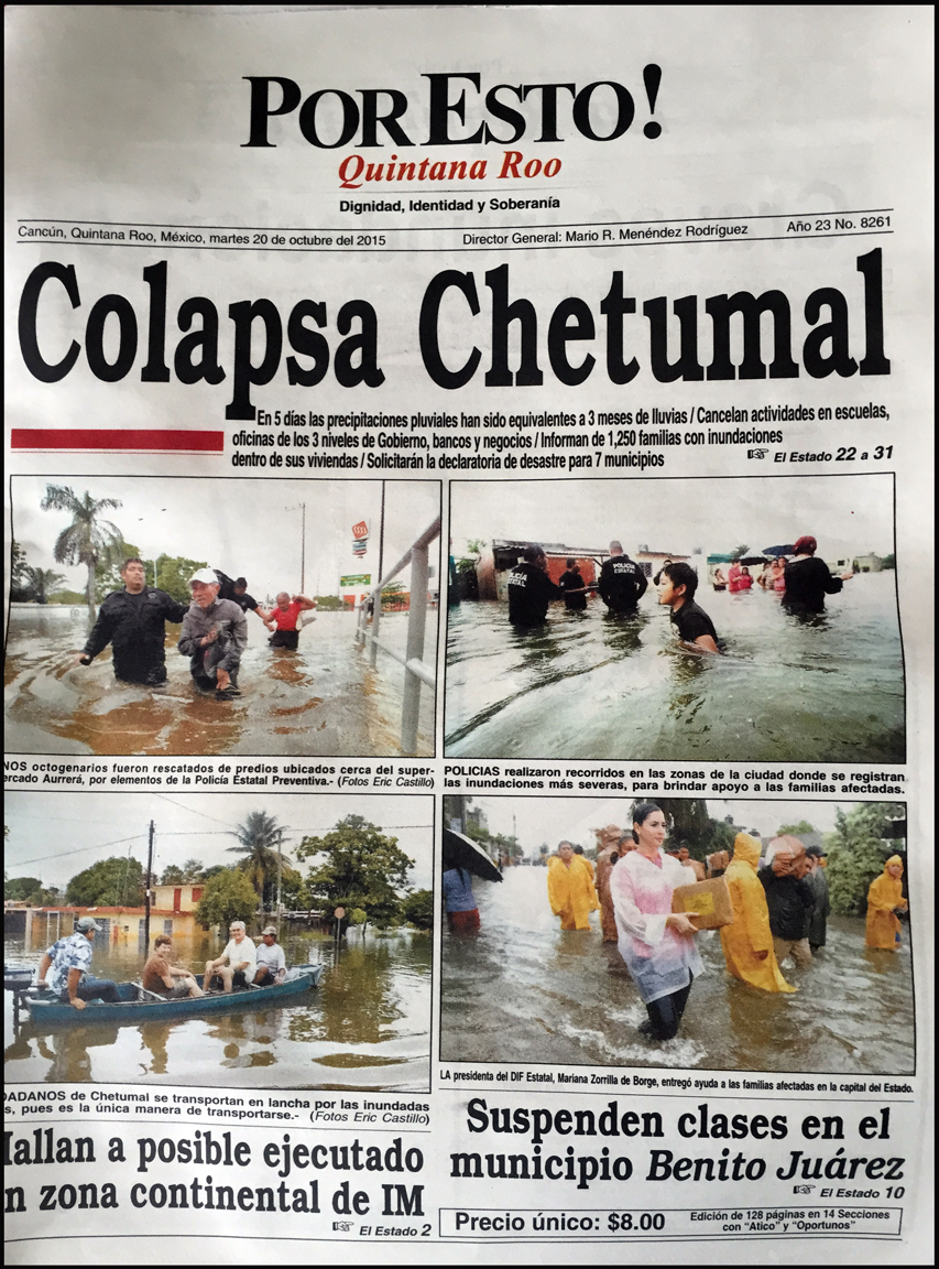
I didn’t want to skip the Rio Bec sites altogether, so we stopped at two that didn’t require any detours: Becan and Chicanna, which are directly across the highway from each other, off Mexico Route 186. We were traveling from Tulum to the city of Campeche, on the Gulf Coast, following the southern route across the lower part of the Yucatan, and that route was going to take us right past those two sites. We’d set a leisurely pace for the day. We left Tulum early that morning, stopping first at the ruins of Muyil, just 20 km to the south. (I described Muyil in detail in my previous post, “Coba and Muyil: Mayan Cities in Quintana Roo”). After Muyil, we kept going south to Chetumal, on the border of Belize–but we didn’t stop there. Less than a week earlier, Chetumal had been the scene of devastating floods that destroyed large sections of the city and a fair bit of their infrastructure:
Newspaper from October 20, 2015. We had a small problem with the weather at that point. Click for expanded view.
The rainy season in southern Mexico is nothing to joke about. We were there in October, which, in an average year, is the last of the wet months. Statistically speaking, that last month of the rainy season is often the wettest of the lot, so my plan to travel at that time of year was a calculated risk. Crowds would be minimal, I reasoned, and that was a good thing. So what if we ran into a little rain? Ha! When we passed through Cancun a few days earlier, we hit the fringes of the same storm system that caused the “Collapse” of Chetumal (see newspaper headline, above). There was so much rain coming down, in such a short span, that there was water in the streets all the way up to the floorboards of my Jeep. Major boulevards were running like rivers, and this was in a modern, master-planned community built with what should have been adequate drainage. In an older urban center, like Chetumal–places that didn’t have the benefit of any sort of planning, where every piece of ground that was halfway flat has a structure on it? Places like Chetumal are a recipe for disaster. Hit them with a “once-in-a-lifetime storm”, one of those lollapalooza gully-washers that seem to be happening with alarming regularity these days? The result will be devastation–collapse–and tragic loss of life. At exactly the same time as this east coast storm, the west coast of Mexico was being slammed by Hurricane Patricia, officially the most powerful hurricane ever recorded, and there were fears that the two systems might collide over central Mexico. That didn’t happen, praise be, but we paid very close attention to the weather reports during that particular week. It’s easier now than it has ever been to stay current with the weather forecast–using your smart phone, the televisions in the bars and hotels, whatever you’ve got. That’s one aspect of modern life that you probably shouldn’t leave behind when you’re traveling about the planet, even (or especially) when you’re off the beaten path.
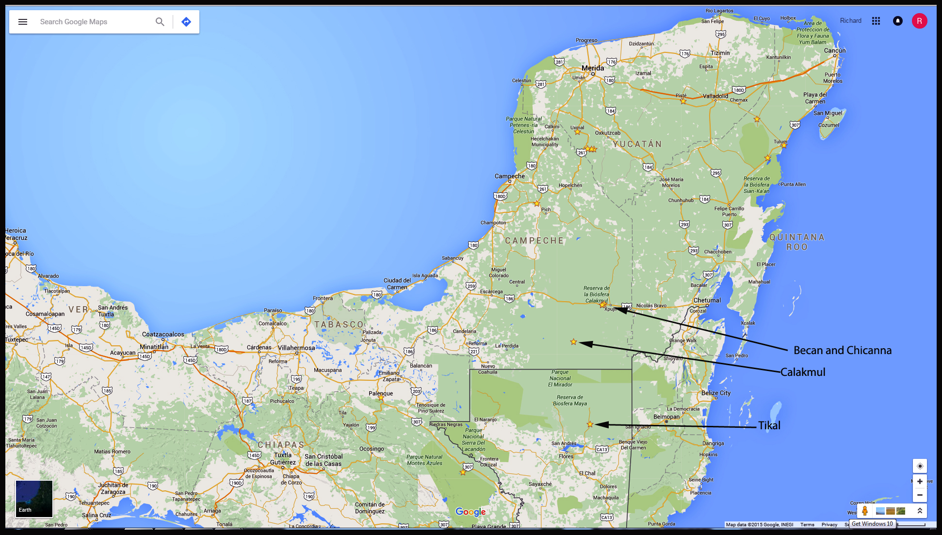
Click map to enlarge.
On the day in question, we bypassed Chetumal and turned due west. After about 123 kilometers, we left the state of Quintana Roo and entered the state of Campeche. Less than 5 km beyond that, we spied the following sign:
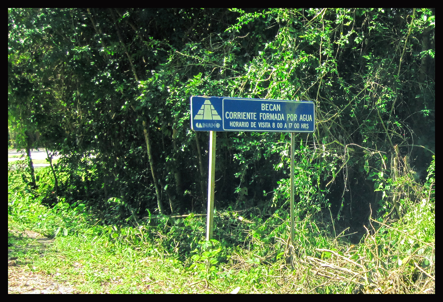
This one was NOT on my bucket list–truth be known, I’d never even heard of it before circling it on my map just a few days before. It had the virtue of being directly along our route, so, why not stop? The first thing we saw walking in was this, the official map of the site, and this map had a feature I’d never seen on any other:
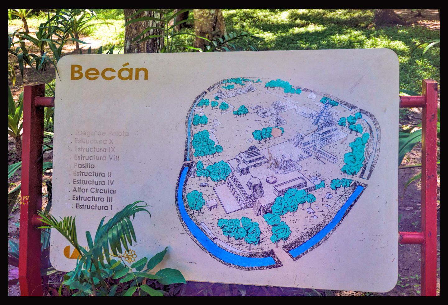
A moat! This Mayan city had an actual moat? Okay, I was officially intrigued. The Mayans didn’t build moats, and yet here, in this place, they’d done exactly that. What secrets lay buried here, within that unique line of defense?
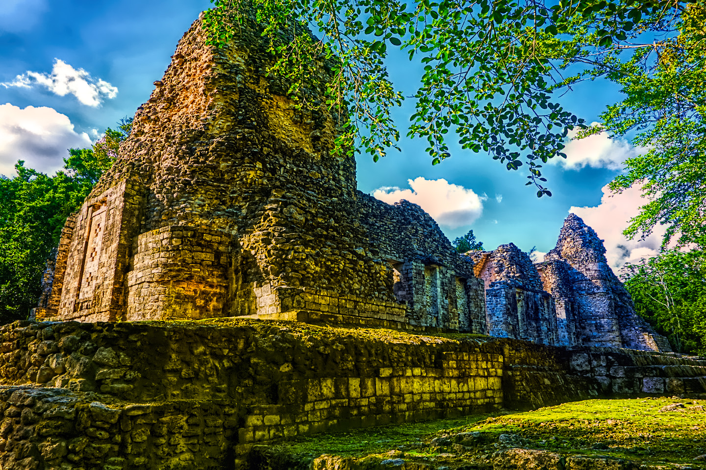
Becan
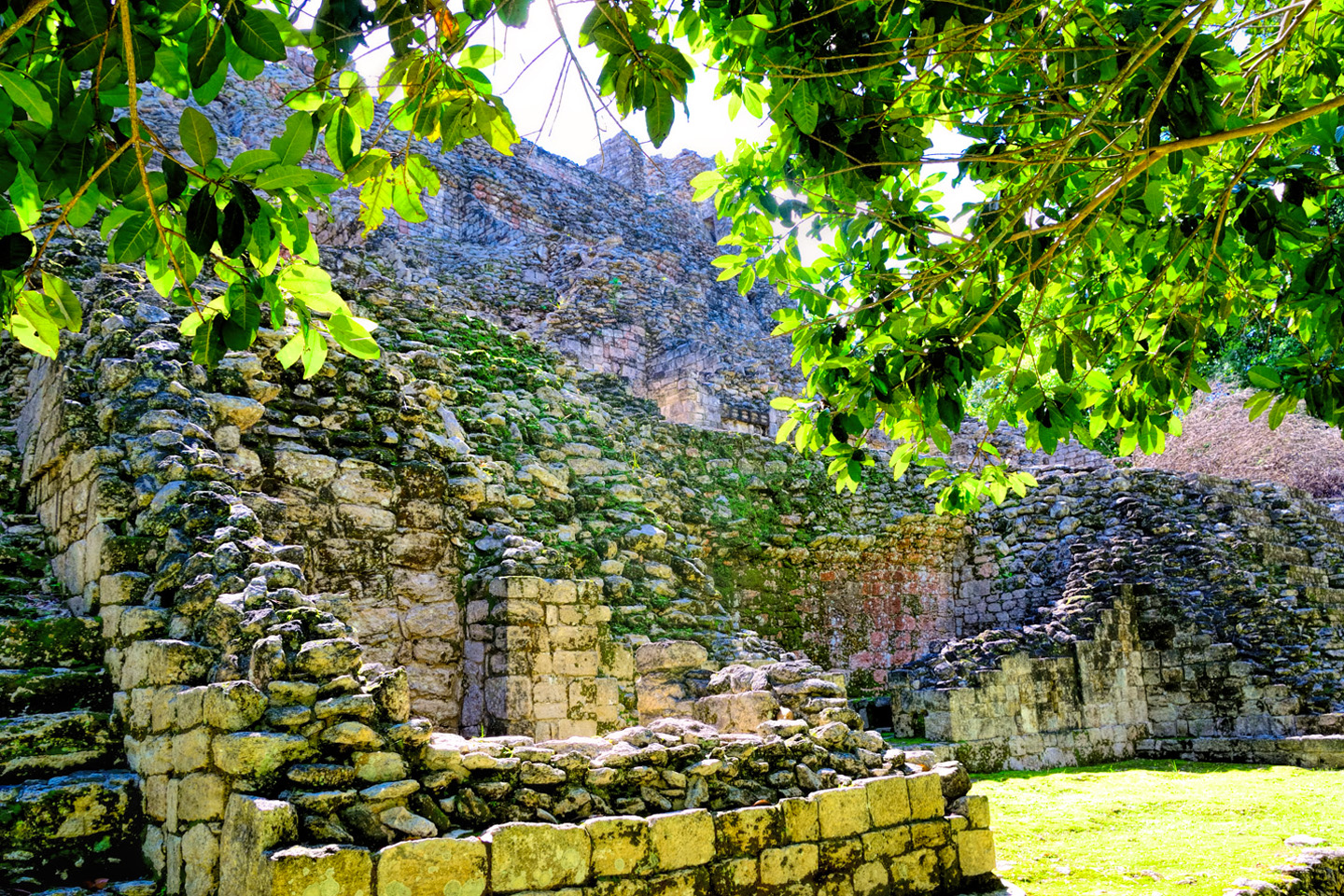
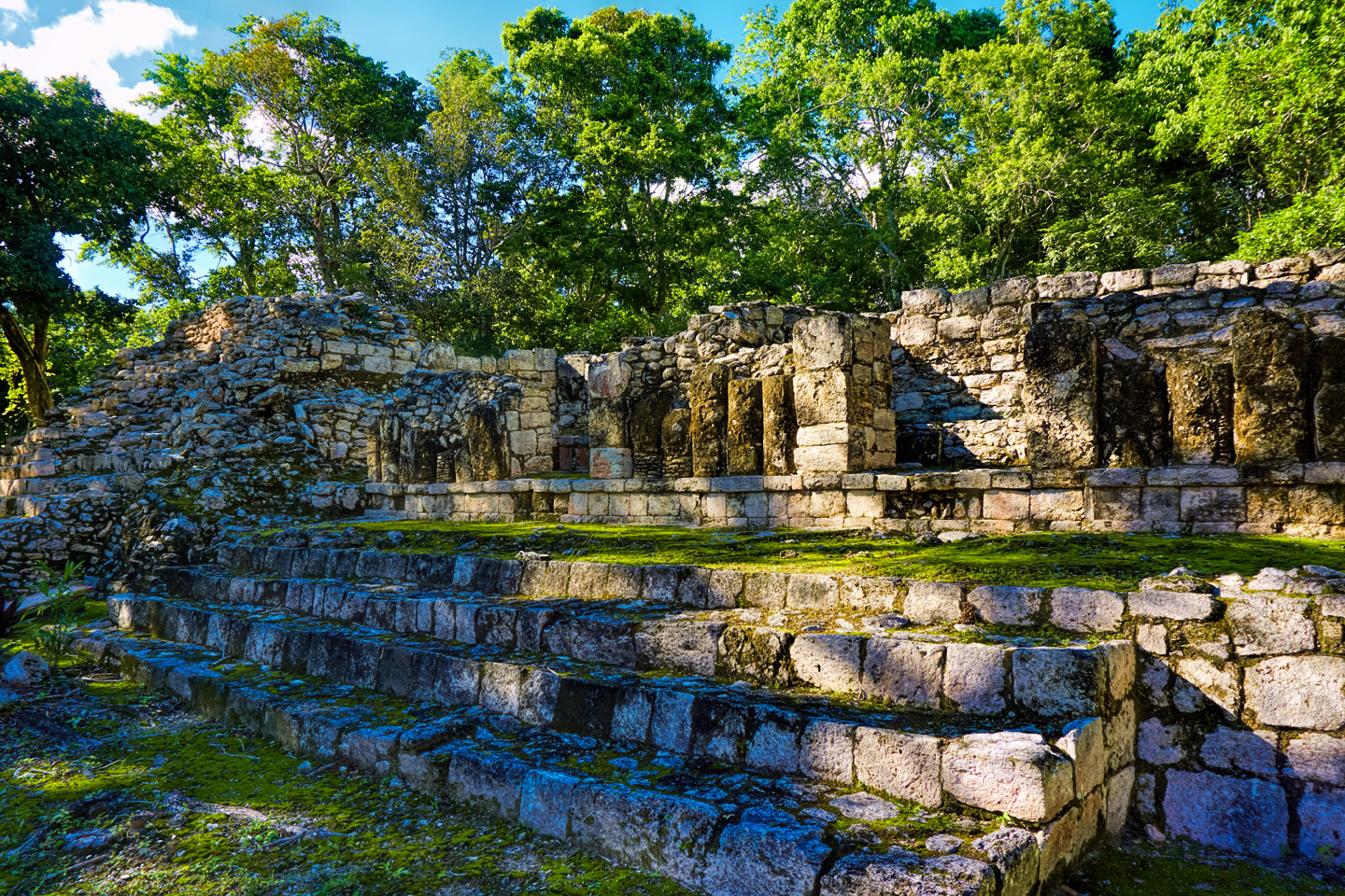
Becan was an independent, self-sustaining City-State, not subordinate to any of the larger centers, such as Calakmul or Tikal. The settlement was first occupied a very long time ago, as early as 550 BC, in the early pre-classic period, and by around 250 AD it had grown into a major population center. The 60 acre site was indeed completely surrounded by an artificial moat, 16 feet deep and 30 feet wide that was built as a barrier against invasion. Dirt and stones removed from the excavation were used to build a fortified wall just inside the moat, creating a formidable double line of defense that puts a lie to the notion that pre-classic Maya were a purely peaceful people. Archaeologists gave the city its name based on this feature: the Mayan word Becan meaning “ravine formed by water”.
There was a surge in the population of Becan around 500 AD, the same time period that saw most of the monumental construction in the ceremonial center. Just as at many other Mayan sites, that construction reached a peak, then essentially stopped by around 830 AD. At that point, the city went into a slow decline, only to be abandoned altogether around 1200 AD. This is consistent with the mysterious collapse of the Mayan civilization in the 13th century, the period when the great majority of the large Mayan ceremonial centers fell out of use, and their remaining populations migrated to other areas. The reason for the collapse is not fully understood, but it’s widely believed that a period of extended drought caused crop failures that made it impossible to sustain the large populations in the vicinity of the larger cities. Ongoing crop failures caused famine and mass starvation, a reduction in the population, a breakdown in the social fabric, and, for those who survived, forced migration to other areas that were better suited to sustainable agriculture. That’s a theory, one of several, but it’s supported by studies that seem to indicate abnormally low precipitation in the region during this time period. We’ll probably never know exactly what happened, but until a better theory comes along, or until further research proves otherwise, we can blame that perennial bad boy: climate change.
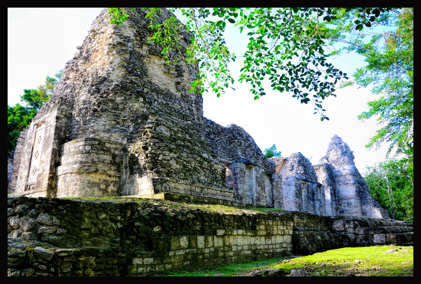
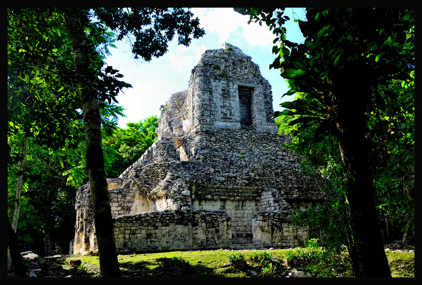
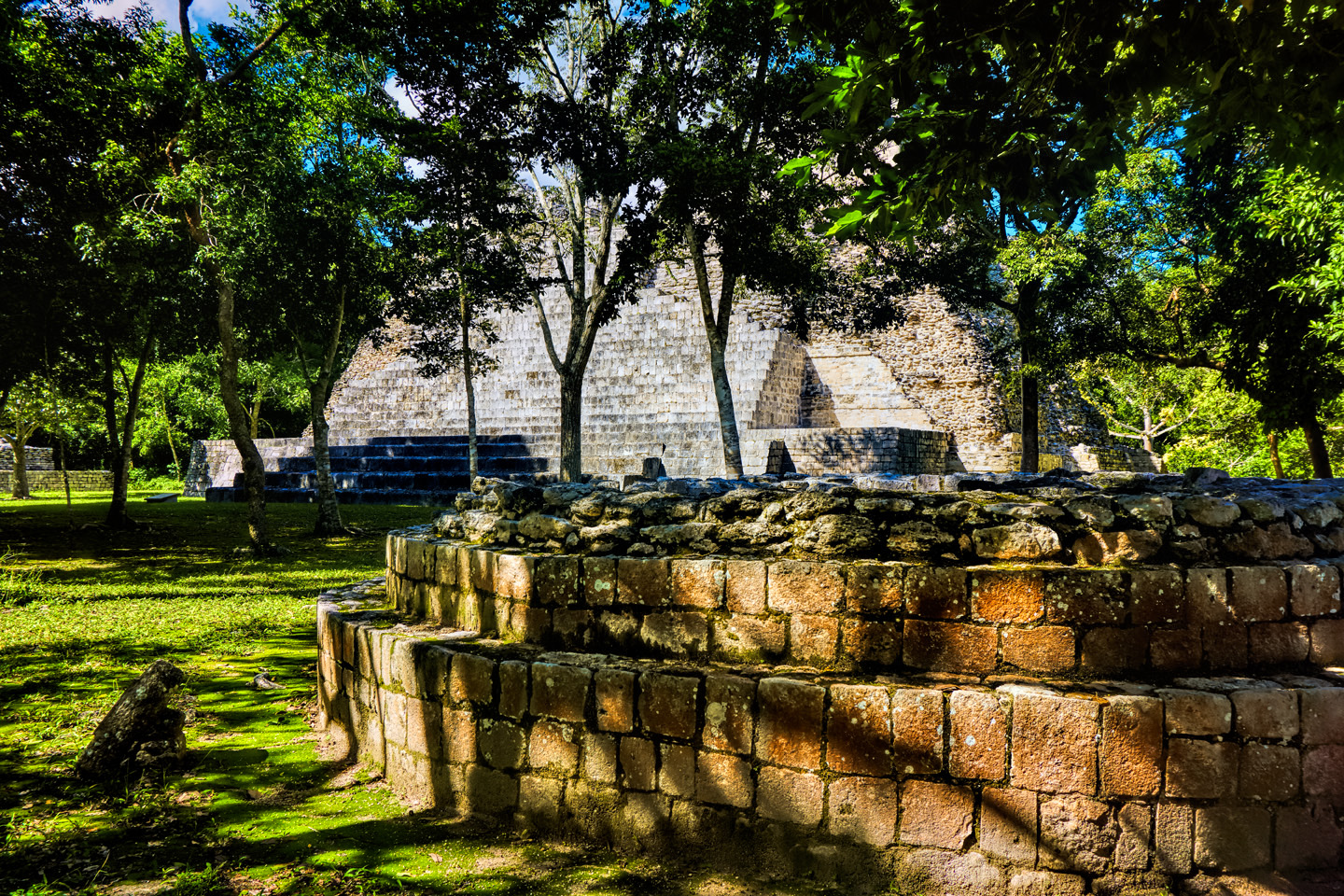
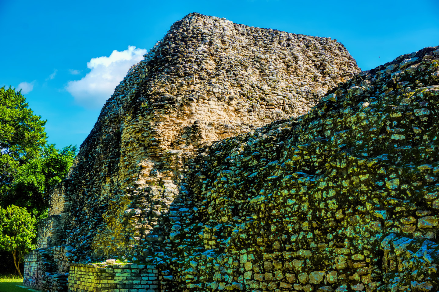
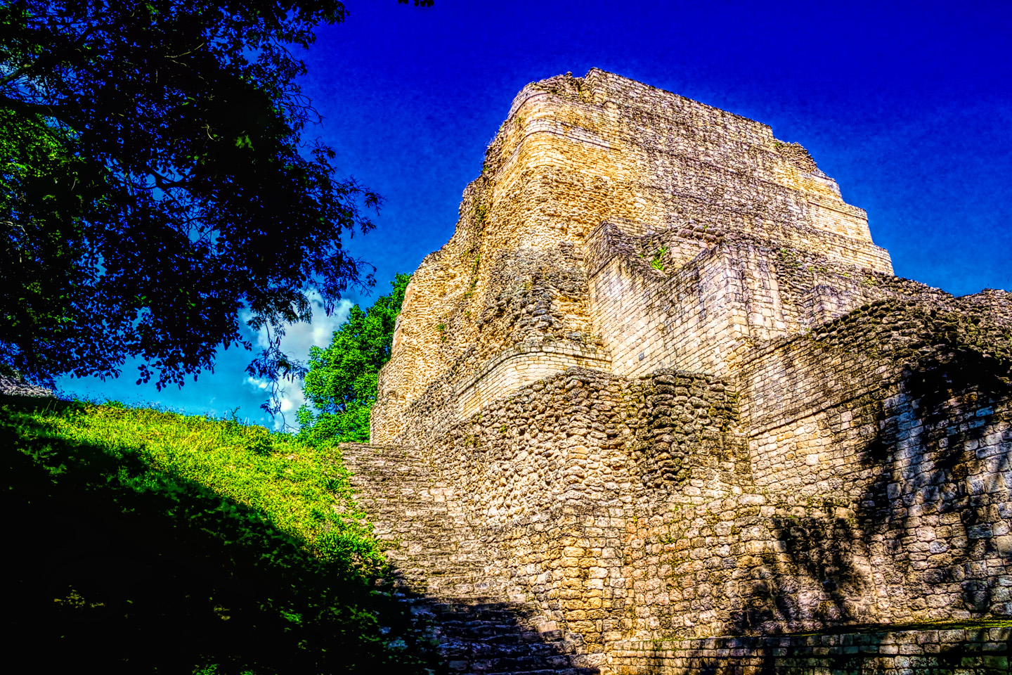
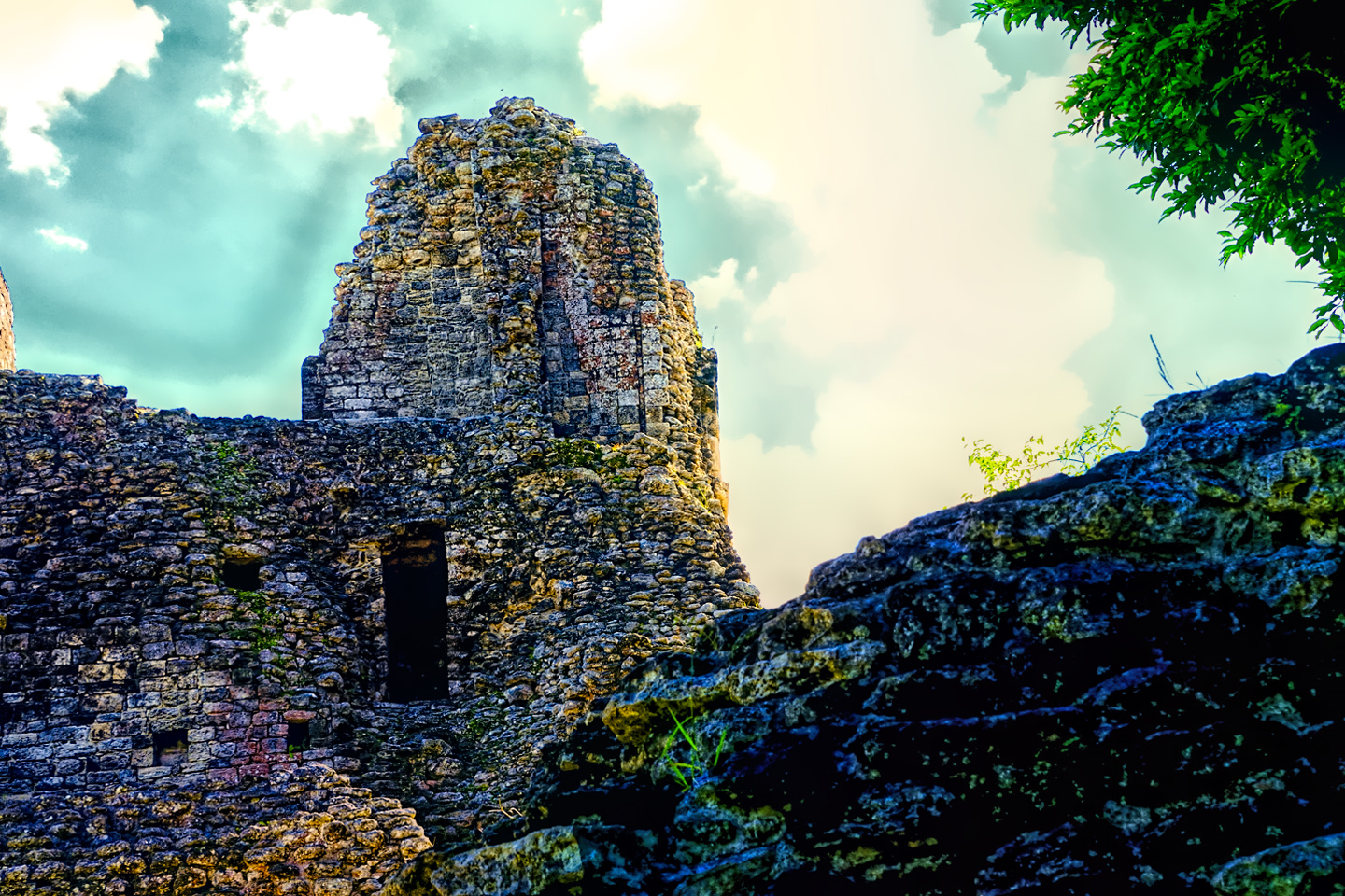
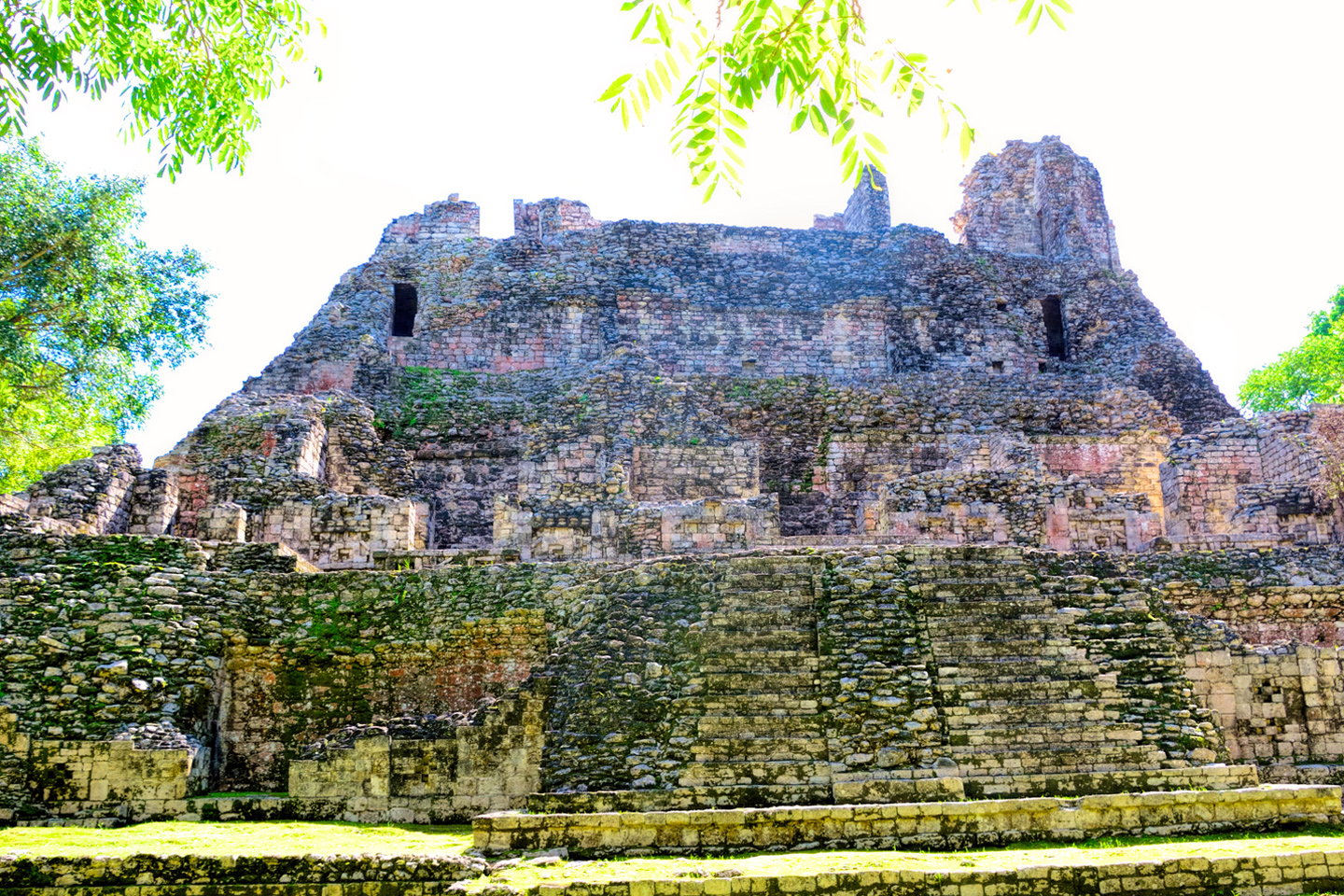
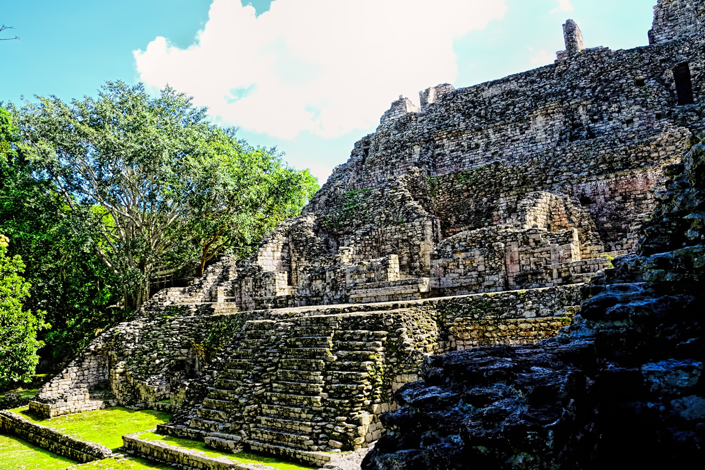
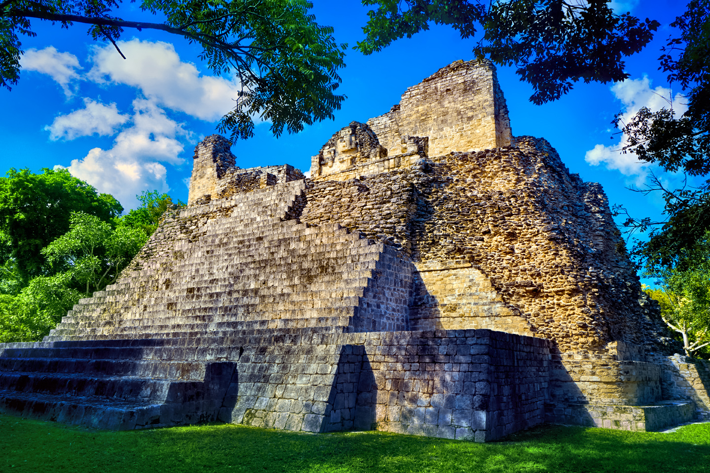
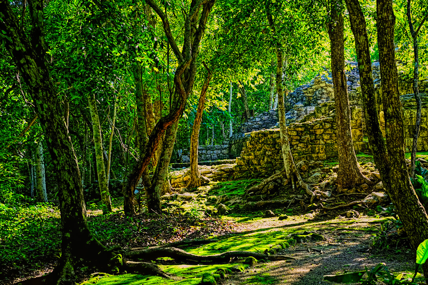
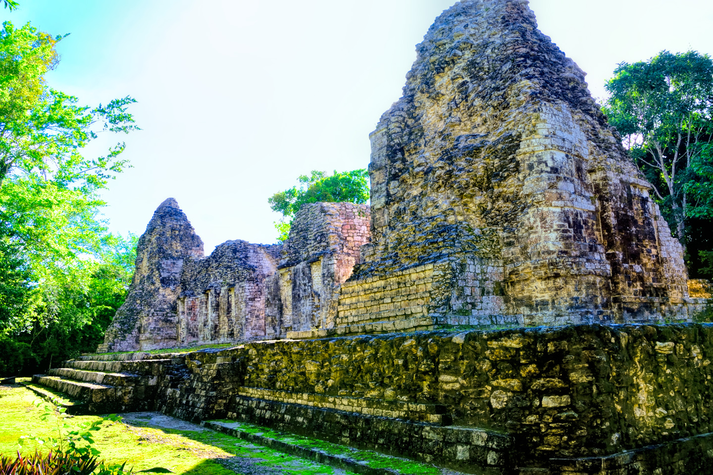
Most of the structures in Becan were built in the Rio Bec style. Instead of the traditional step pyramid topped by a temple, as found in other locations, the Rio Bec sites built wide structures with twin towers on either end that narrowed toward their tops, giving the illusion of greater height. Much about this architectural style was based on illusion: common elements include staircases that go nowhere and serve no function, false doorways into alcoves that end in blank walls, and buildings that appear to be temples, but are actually solid structures with no interior space. In these locations, form won out over function, and the massive structures were–no joke–strictly for show.
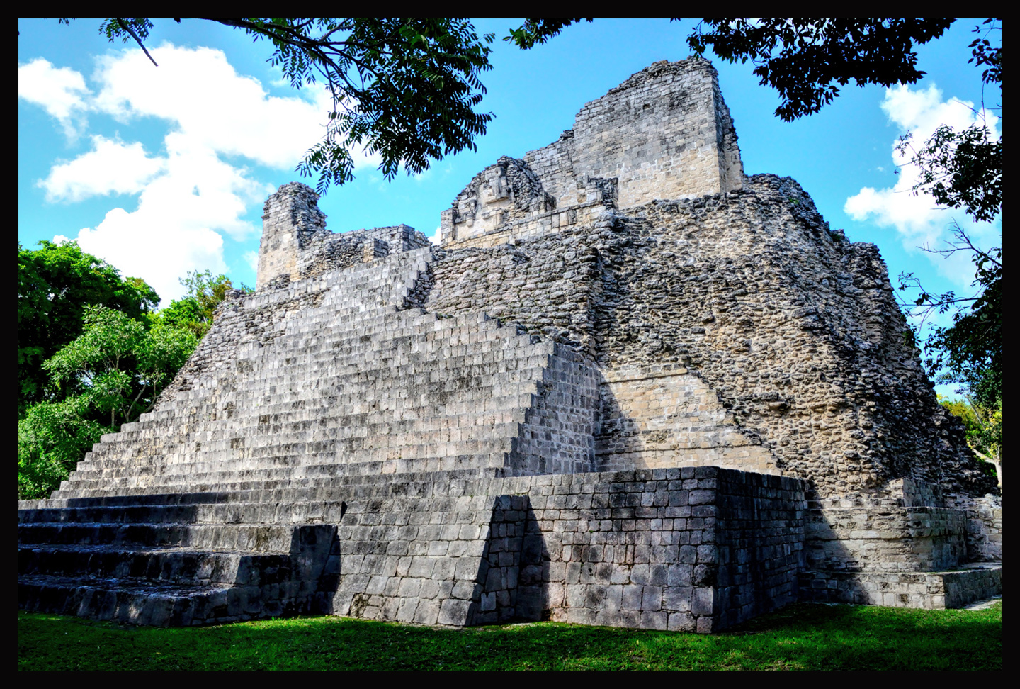
The largest edifice at Becan. The buildings at this site were never given fanciful names, in the manner of most other Mayan cities, so this classic example of Rio Bec architecture is known simply as Structure IX.
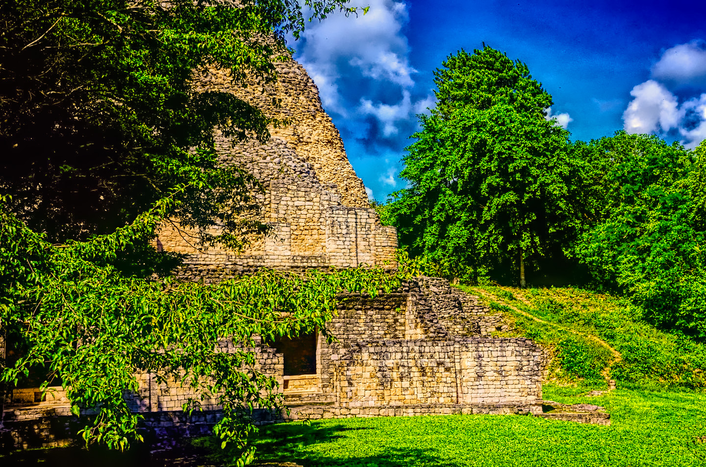
Chicanna
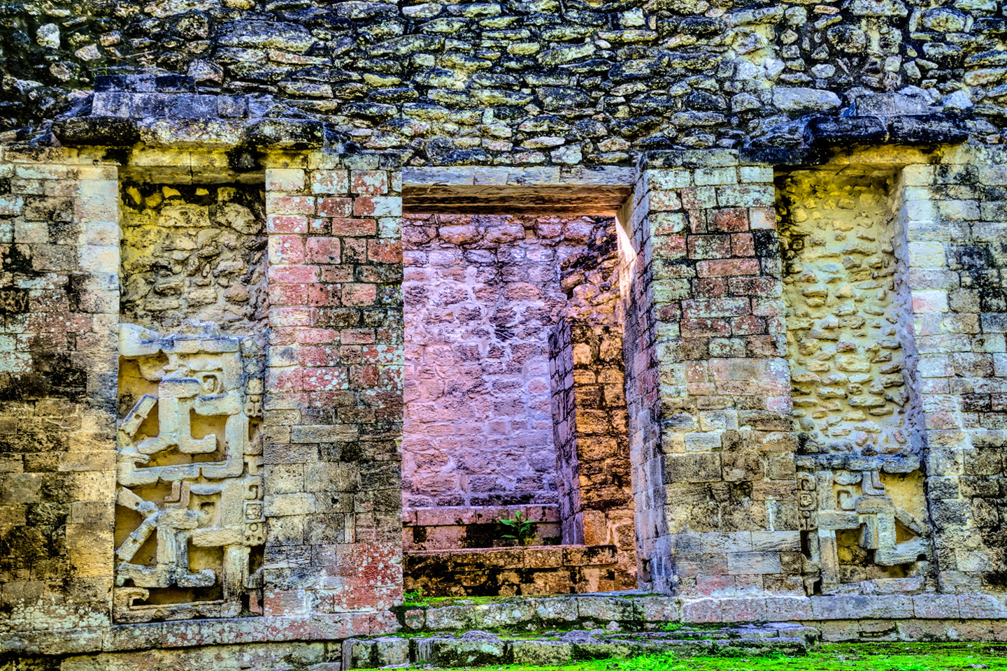
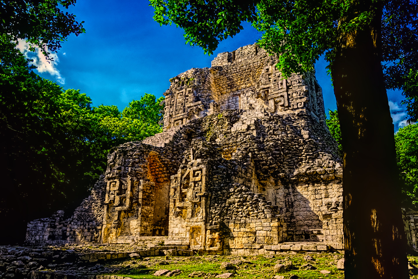
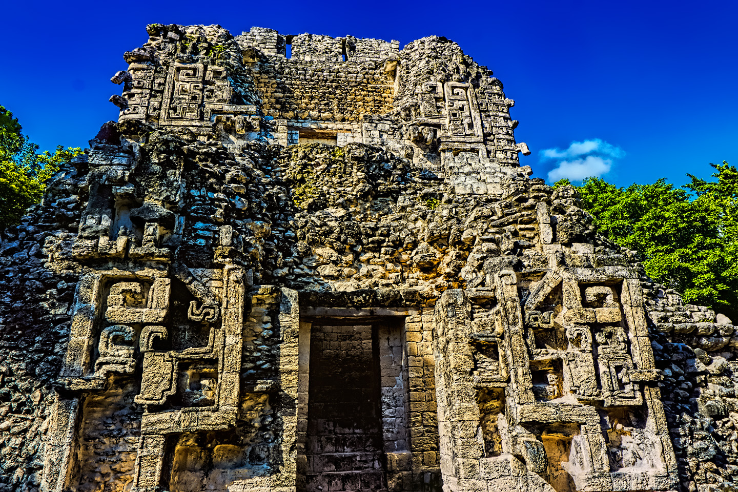
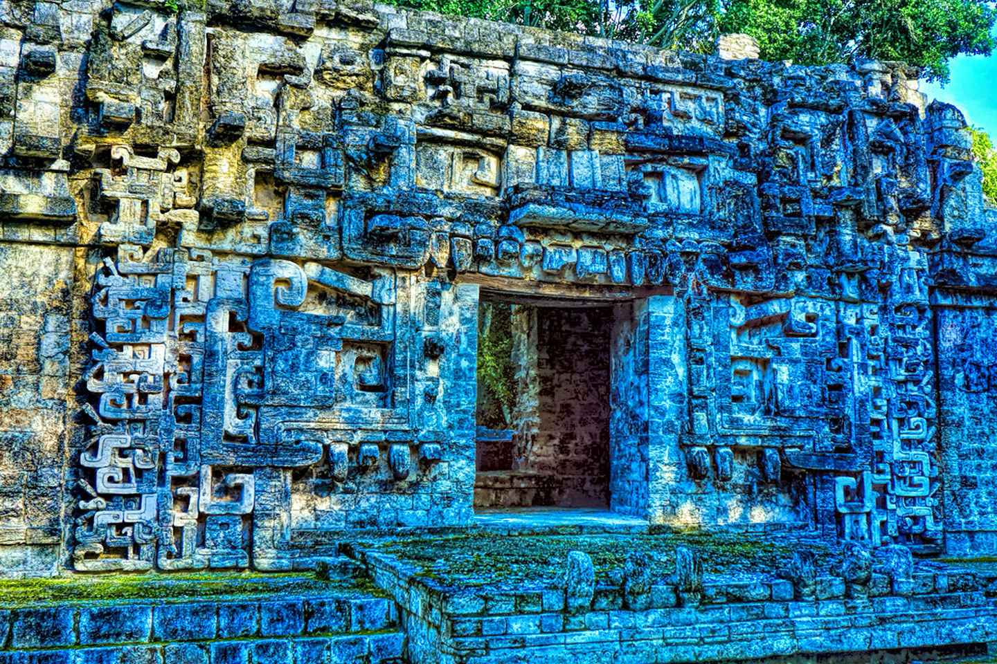
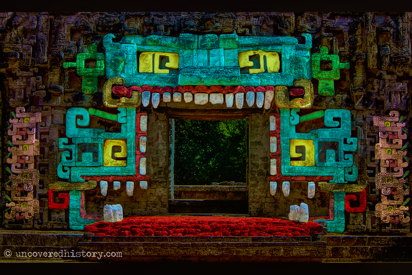
Chicanna is on the other side of the highway, just 2 km from Becan. It’s a fair bit smaller than its neighbor, and has no particularly large buildings. Still, it’s a rather interesting site in its own right, with some unique features. The name means “House of the Serpent Mouth” in the Mayan language, which is a fair description of its most famous building, officially, “Structure II” a free-standing portico representing the stylized mouth of a serpent, complete with teeth:
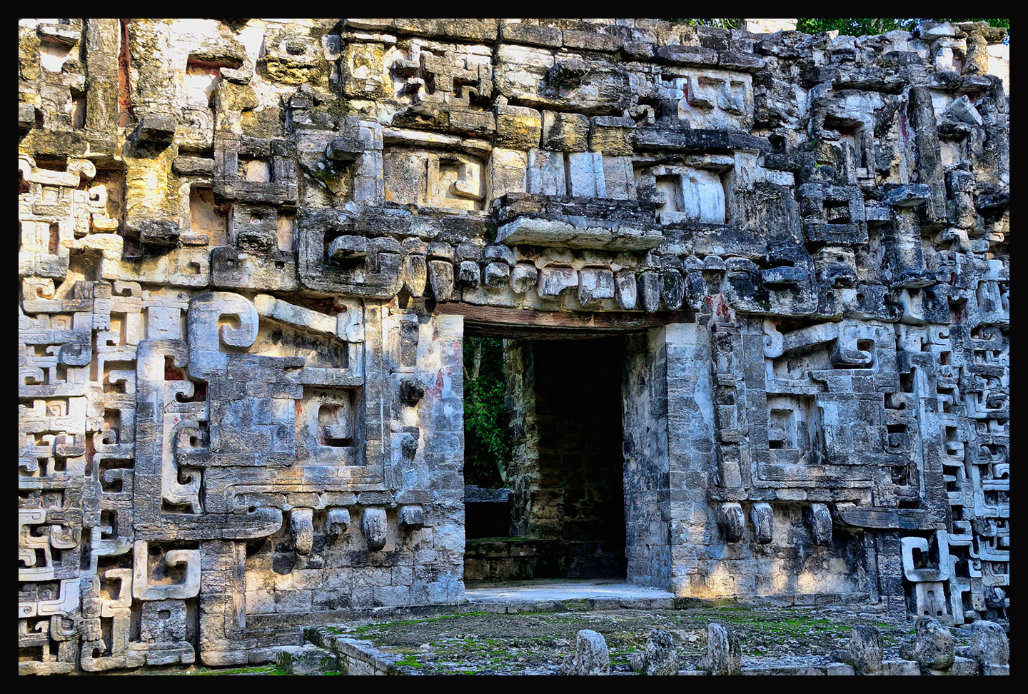
House of the Serpent Mouth: Click for an expanded view
You’ll need to use your imagination to visualize this, but the ornate carvings surrounding this portico (above) represent the eyes, the snout, and the teeth of a snake. The open doorway is the mouth, hence the name, “House of the Serpent Mouth”. That’s “Chicanna”, in the Mayan language: Chi (mouth) Can (serpent) Na (house). It’s thought that the priests would disappear through this door during ceremonies, to symbolize their entry into the underworld to commune with the gods. Back in the day, the wall would have been painted, so the eyes and teeth would have stood out garishly, and with the priests in their elaborate feathered costumes, that little bit of stagecraft would have been quite a spectacle! Awe inspiring? More likely terrifying to the common folk.
Chicanna was first occupied around 300 BC, about 50 years after Becan got its start, and was abandoned around 1100 AD, which was about 100 years sooner than Becan. It’s thought that Chicanna was actually an exclusive enclave for Becan’s elite, a segregated suburb for the rich and famous. The houses were finer, the temples more ornate. Nothing was too elaborate for the noble folk, and when times were good, they lived like kings. Chicanna peaked early, from the time of its founding until around 250 AD, and it remained, throughout its existence, intertwined with its patron, Becan. There’s nothing big here, no pyramids, just an assortment of smaller structures, done in a hodge-podge of architectural styles.
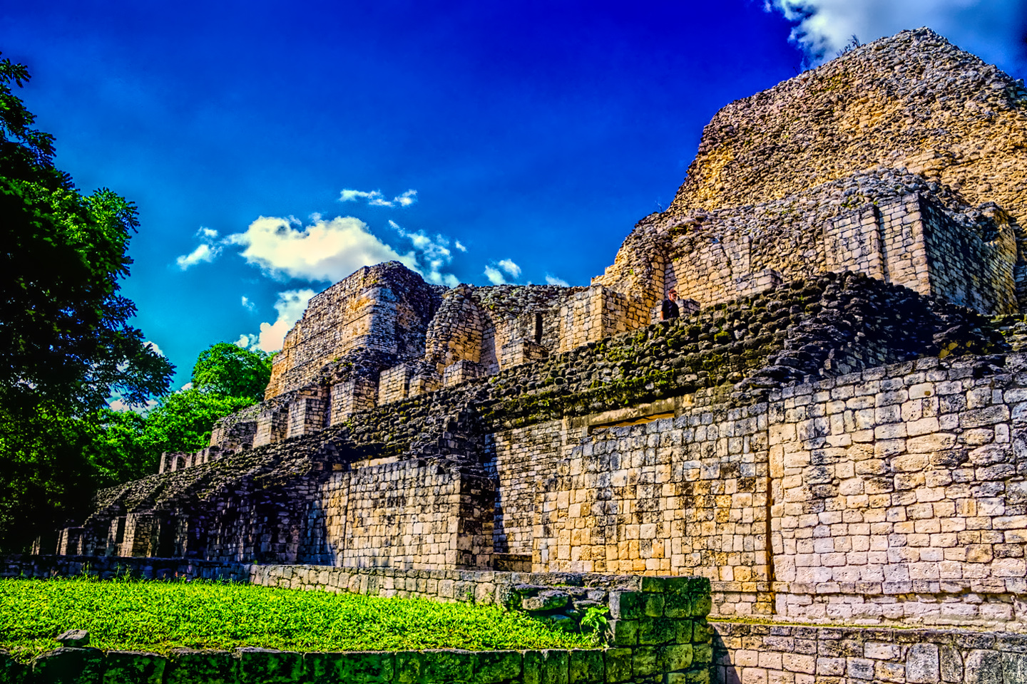
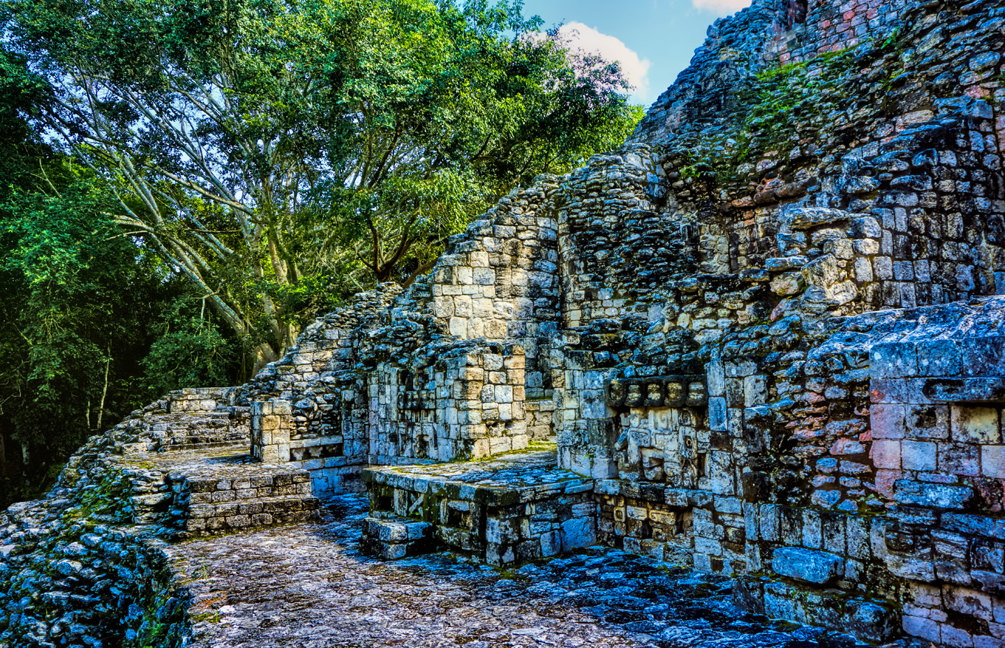
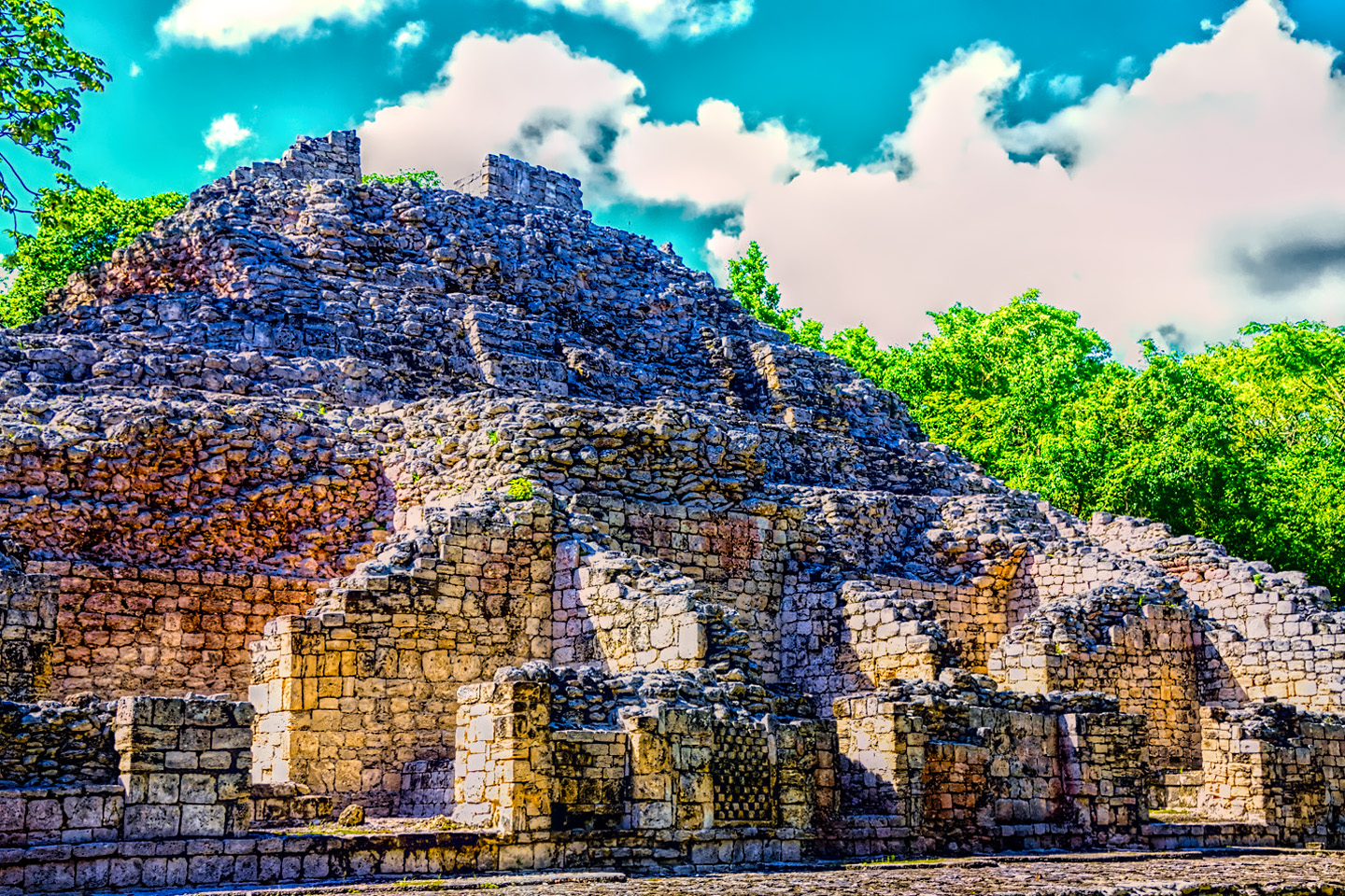
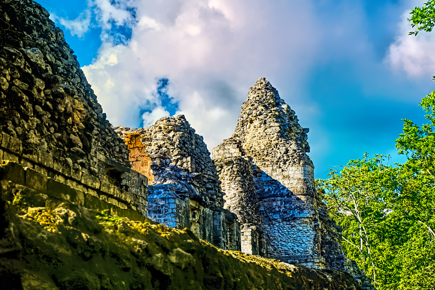
There’s a Rio Bec influence, as might be expected:
Typical Rio Bec architectural style structure, featuring twin towers, false pyramids, on either end of a basal platform.
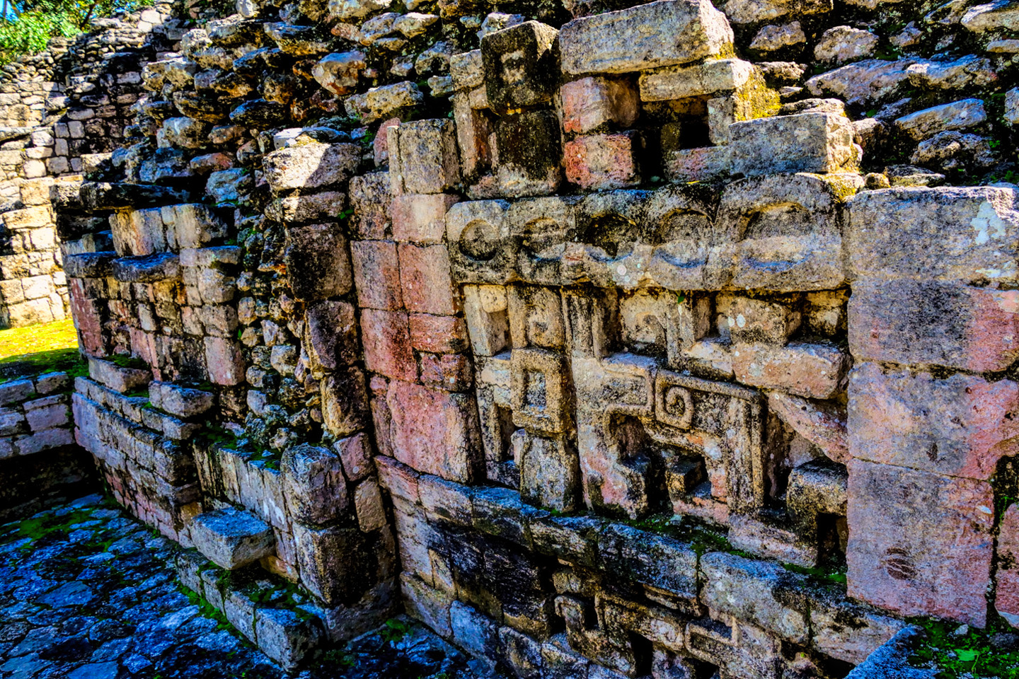
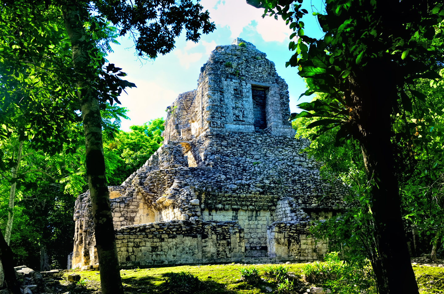
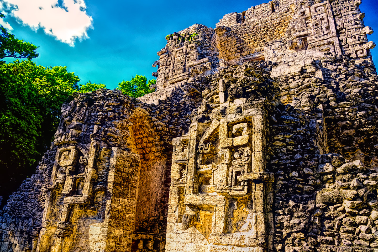
This is combined with the Chenes style, as exemplified by the serpent mouth doorway, and by the front facade of this building, Structure XX:
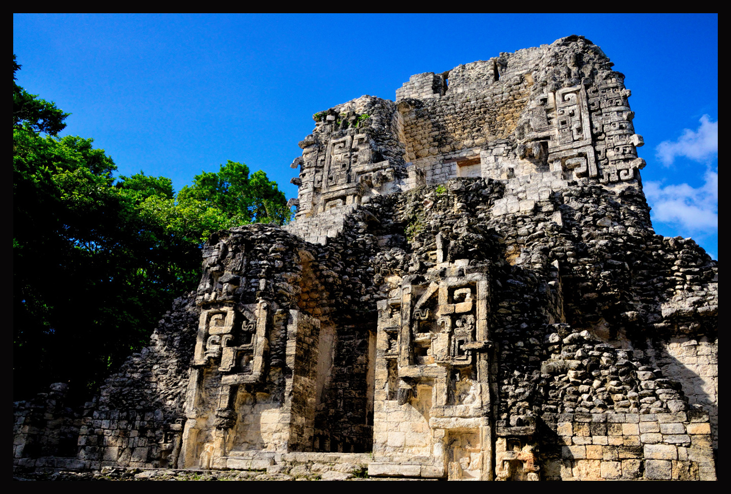
The entire front side of Structure XX is a giant zoomorphic mask in the Chenes architectural style
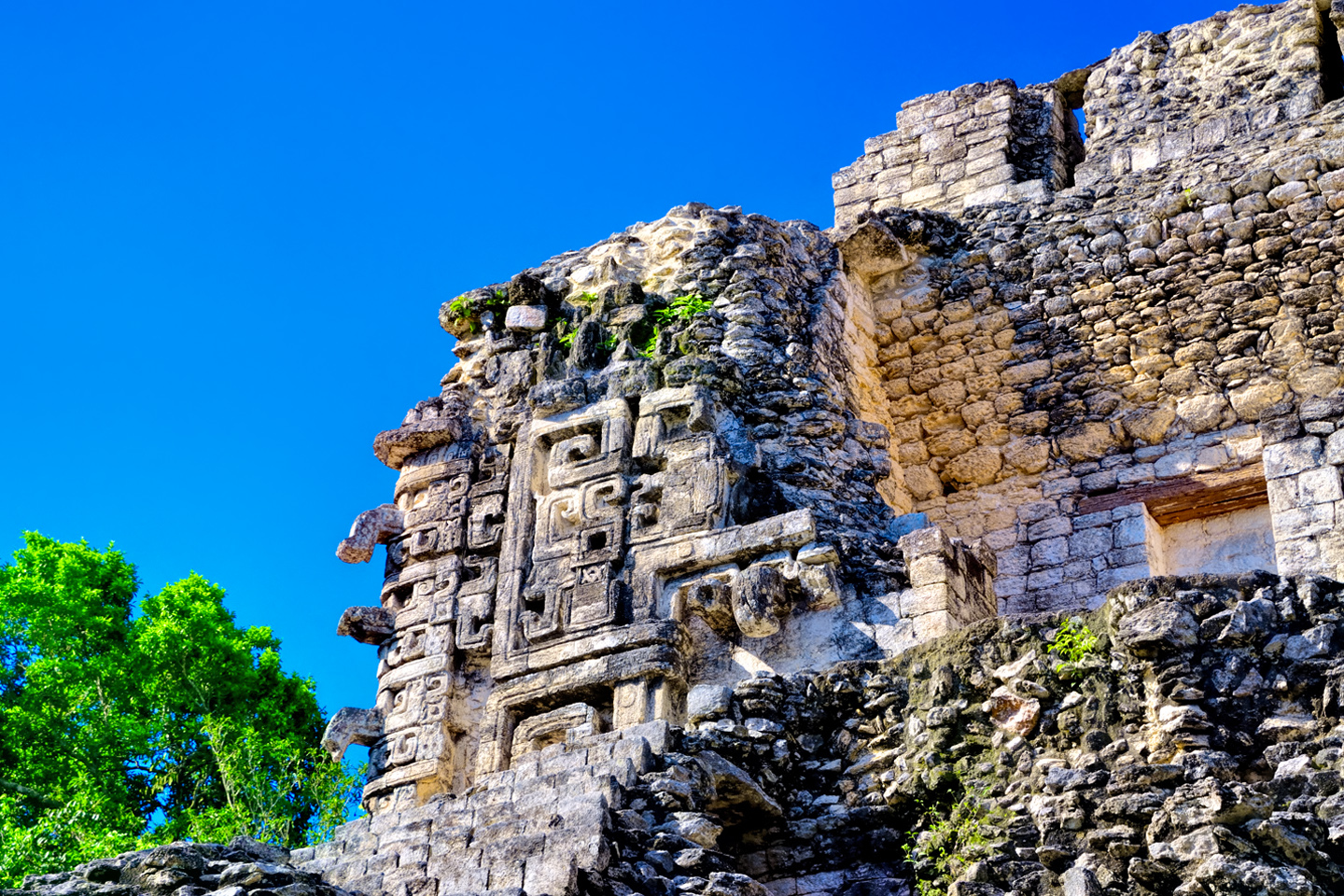
There is also a bit of Puuc influence, apparent in the elaborate facades with geometric patterns on the upper portion of some of the buildings, including the back side of Structure XX, the tallest structure at Chicanna:
Elaborate geometric patterns on the upper facade of Structure XX are typical of the Puuc architectural style
These two sites are absolutely worth visiting, but unless you just happen to be passing by, the way I was, my recommendation would be to combine these with a trip to Calakmul, and possibly to Rio Bec, or El Ramonal (which you’ll pass right by on your way to Calakmul). If you do go, however you get there, you’ll find these all-but-empty Rio Bec sites a delightful change of pace from the jam-packed attractions closer to Cancun.
The photo collage (below) contains additional photos from Becan and Chicanna;
Click photos to expand the images to full-screen:
(Unless otherwise noted, all of these images are my original work, and are protected by copyright. They may not be duplicated for commercial purposes.)
READ MORE LIKE THIS:
This is an interactive Table of Contents. Click the thumbnails to open the pages.
ON THE ROAD IN MEXICO

MEXICAN ROAD TRIP: HOW TO PLAN AND PREPARE FOR A DRIVE TO THE YUCATAN
The published threat levels are a “full-stop” deal breaker for the average tourist. That’s unfortunate, because Mexican road trips are fantastic! Yes, there are risks, but all you have to do to reduce those risks to to an acceptable level is follow a few simple guidelines.
<<CLICK to Read More!>>

Mexican Road Trip: Heading South, From Laredo to Villahermosa
When it was our turn, soldiers in SWAT gear surrounded my Jeep, and an officer with a machine gun gestured for me to roll down my window. He asked me where we were going. I’d learned my lesson in customs, and knew better than to mention the Yucatan. “We’re going to Monterrey,” I said, without elaborating.
He checked our ID’s and our travel documents, then handed them back. “Don’t stop along the way,” he advised. “You need to get off this road and to a safe place as quickly as you can!”
<<CLICK to Read More!>>

Mexican Road Trip: Zapatista Road Blocks in Chiapas
“Good morning,” I said. “We’re driving to Palenque. Will you allow us to pass?”
The leader of the group, a young Mayan lad, walked up beside my Jeep, and fixed me with a menacing glare. “The road is closed,” he said, keeping his hand on the hilt of his machete. “By order of the Ejército Zapatista de Liberación Nacional!”
“Is it closed to everyone?” I asked innocently. “How about if we pay a toll? How much would the toll be?”
He gave me an even more menacing glare. “That will cost you everything you’ve got,” he said gruffly, brandishing his machete, while his companions did the same.
<<CLICK to Read More!>>

Mexican Road Trip: Mayan Ruins and Waterfalls in the Lacandon Jungle
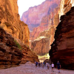
The next morning, we were waiting at the entrance to the Archaeological Park a half hour before they opened for the day. We were the only ones there, so they let us through early, and I had the glorious privelege of photographing that wonderful ruin in the golden light of early morning, without a single fellow tourist cluttering my view.
<<CLICK to Read More!>>

Mexican Road Trip: Merida and the Meridanos
Merida is the largest city in southern Mexico, with a population of almost a million. Statistically, Yucatan is the safest of Mexico’s states, and Merida is widely considered the safest of all Mexico’s cities.
<<CLICK to Read More!>>


Mexican Road Trip: Cancún, Tulum, and the Riviera Maya
The millions of tourists who fly directly to Cancún from the U.S. or Canada are seeing the place out of context. They can’t possibly appreciate the fact that they’re 2,000 miles south of the border; a whole country, a whole culture, a whole history away from the U.S.A. Just looking around, on the surface? The second largest city in southern Mexico could easily pass for a beach town in Florida.
<<CLICK to Read More!>>

Mexican Road Trip: Circling the Yucatan, from Quintana Roo to Campeche
The Castillo at Muyil isn’t huge, as Mayan pyramids go, topping out at just over 50 feet, but it’s definitely imposing. Try to imagine: the equivalent of a five story building, with a three story grand staircase, just appearing, out in the middle of nowhere? Boo-yah!
<<CLICK to Read More!>>

Mexican Road Trip: Edzná, and Campeche, Where They Dance La Guaranducha
La Guaranducha, a traditional dance from Campeche, is a celebration of life, community, and the joy of existence. On stage, there was a group of young men and women in traditional dress, but it was clear that the guys were little more than props, because all eyes were on the girls. So colorful, and so elegant, hiding coyly behind their pleated, folding hand fans.

Mexican Road Trip: Adventures Along the Puuc Route
All of these communities in the Puuc region were allied, politically, culturally, economically, and socially. The Puuc was the cradle of the Golden Age of the Maya. Labna and Sayil were among the brightest jewels in the crown of a realm that never quite coalesced into an empire.
<<CLICK to Read More!>>

Mexican Road Trip: The Road to Bonampak
Rainwater seeping through the limestone walls of the temple soaked the Bonampak Murals with a mineral-rich solution that, each time it dried, left behind a sheen of translucent calcite. The built-up coating protected the paintings for more than 1200 years. As a result, we’re left with the finest examples of ancient art from the Americas to have survived into our modern era.

Mexican Road Trip: Crossing the Chiapas Highlands, to San Cristobal de las Casas
MX 199 crosses the Chiapas Highlands from Palenque to San Cristobal de las Casas. The distance is only 132 miles, but it’s 132 miles of curvy mountain roads with switchbacks, steep grades, slow trucks, and villages chock-a-block with topes and bloqueos, unofficial road blocks. Everything I read, and everything I heard, described the drive as alternatively spectacular, dangerous, and fascinating, in seemingly equal measure.

Mexican Road Trip: Cruising the Sierra Madre, from San Cristobal to Oaxaca
Today, we’d be driving as far as the city of Oaxaca, 380 miles of curves, switchbacks, and rolling hills that would require at least ten hours of our full attention, crossing the Sierra Madre de Chiapas, and entering the rugged, agave-studded landscape of the Sierra Madre de Oaxaca. If you’d like to know what that was like, read on!

Mexican Road Trip: Flashing Lights in the Rear View: Officer Plata and La Mordida
As we drove away from the toll plaza, a State Police car that had been parked off to one side made a fast U-Turn and started following me. A moment later, he turned on his flashers and gave me a short blast on his siren, motioning for me to pull over. Two uniformed policemen got out, and approached me on the driver’s side. One of them hung back, apparently checking out my license plate before making a phone call.
I wasn’t sure if I was being stopped for some infraction, or if these guys were just fishing…

Mexican Road Trip: Three Days of the Dead in San Miguel de Allende
By mid-afternoon, the Jardin was beginning to fill with people. Painted faces were literally everywhere! It was like a costume party, but the venue wasn’t some hall or other indoor space, it was the whole entire town! Mike and I were definitely getting into the spirit of the thing–but we still drew the line at the notion of painting our beards…
Mexican Road Trip: Back to the Border: San Miguel de Allende to Eagle Pass
Saltillo was our crossroads: if we turned east here, we’d be retracing our previous route to the border at Nuevo Laredo–along the Highway of Death! This time, we knew better, so we turned north, toward Monclova, and Piedras Negras.


Southern Colonials: Merida, Campeche, and San Cristobal
Visiting the Spanish Colonial cities of Mexico is almost like traveling back in time. Narrow cobblestone streets wind between buildings, facades, and stately old mansions that date back three hundred years or more, along with beautiful plazas, parks, and soaring cathedrals, all of similar vintage.
<<CLICK to Read More!>>

San Miguel de Allende, Mexico’s Colonial Gem
If you include the chilangos, (escapees from Mexico City), close to 20% of the population of San Miguel de Allende is from somewhere else, a figure that includes several thousand American retirees.
<<CLICK to Read More!>>

Day of the Dead in San Miguel de Allende
In San Miguel de Allende, they’ve adopted a variation on the American version of Halloween and made it a part of their Day of the Dead celebration. Costumed children circle the square seeking candy hand-outs from the crowd of onlookers. It’s a wonderful, colorful parade that’s all about the treats, with no tricks!
<<CLICK to Read More!>>
IN THE LAND OF THE MAYA

Palenque: Mayan City in the Hills of Chiapas
Palenque! Just hearing the name conjures images of crumbling limestone pyramids rising up out of the the jungle, of palaces and temples cloaked in mist, ornate stone carvings, colorful parrots and toucans flitting from tree to tree in the dense forest that constantly encroaches, threatening to swallow the place whole.
<<CLICK to Read More!>>

Uxmal: Architectural Perfection in the Land of the Maya
The Pyramid of the Magician is one of the most impressive monuments I’ve ever seen. There’s a powerful energy in that spot–maybe something to do with all the blood that was spilled on the altars of human sacrifice at the top of those impossibly steep steps–but more than any building or other structure at any ancient ruin I’ve ever visited, more than any demonic ancient sculpture I’ve ever seen, that pyramid at Uxmal quite frankly scared the hell out of me!
<<CLICK to Read More!>>

The Mayan City of Edzná: First House of the Itzás
The Mayan Edzná is nothing less than epic, lyrical poetry, an extraordinary sonnet comprised of temples and palaces carved in stone that have stood, in regal grandeur, for more than a thousand years.
<<CLICK to Read More!>>

Photographer’s Assignment: Chichén Itzá
To get the best photos, arrive at the park before it opens at 8 AM. There will only be a handful of other visitors, and you’ll have the place practically all to yourself for as much as two hours! Take your time composing your perfect shot.There won’t be a single selfie stick in sight.
<<CLICK to Read More!>>

Chichén Itzá: Requiem for the Feathered Serpent
The feathered serpent with the unquenchable thirst for blood may be gone now, or at least fallen out of favor, but as long as the ruins of this ancient city remain standing, he won’t be forgotten.
<<CLICK to Read More!>>

Tulum: The City that Greets the Dawn
Tulum is not all that large, as Mayan sites go, but its spectacular location, right on the east coast of the Yucatan Peninsula, makes it one of the best known, and definitely one of the most picturesque.
<<CLICK to Read More!>>

Cobá and Muyil: Mayan Cities in Quintana Roo
Cobá was a trading hub, positioned at the nexus of a network of raised stone and plaster causeways known as the sacbeob, the white roads, some of which extended for as much as 100 kilometers, connecting far-flung Mayan communities and helping to cement the influence of this powerful city.
<<CLICK to Read More!>>

Becan and Chicanná: Mayan Cities in the Rio Bec Style
Much about the Rio Bec architectural style was based on illusion: common elements include staircases that go nowhere and serve no function, false doorways into alcoves that end in blank walls, and buildings that appear to be temples, but are actually solid structures with no interior space.
<<CLICK to Read More!>>

The Puuc Hills: Apex of Mayan Architecture
The Puuc style was a whole new way of building. The craftsmanship was unsurpassed, and some of the monumental structures created in this period, most notably the Governor’s Palace at Uxmal, rank among the greatest architectural achievements of all time.
<<CLICK to Read More!>>

The Amazing Mayan Murals of Bonampak
Out of that handful of Mayan sites where mural paintings have survived, there is one in particular that stands head and shoulders above the rest. One very special place. Down by the Guatemalan border, in a remote corner of the Mexican State of Chiapas: a small Mayan ruin known as Bonampak.
<<CLICK to Read More!>>
A shout out to my old friend Mike Fritz (aka Mr. Whiskers), my shotgun rider on my Mexican Road Trip. “Drive to the Yucatan and See Mayan Ruins” was at the top of my post-retirement bucket list, right after “Drive the Alaska Highway and see Denali.” We checked off the whole Yucatan thing in a major way, and Mike was a heck of a good sport about it.
Road trips with old friends are the absolute best. We laugh and we laugh until we run out of breath, and laughter is good for the soul!


There’s nothing like a good road trip. Whether you’re flying solo or with your family, on a motorcycle or in an RV, across your state or across the country, the important thing is that you’re out there, away from your town, your work, your routine, meeting new people, seeing new sights, building the best kind of memories while living your life to the fullest.
Are you a veteran road tripper who loves grand vistas, or someone who’s never done it, but would love to give it a try? Either way, you should consider making the Southwestern U.S. the scene of your own next adventure.
A few years ago I wrote a book about road trips in Arizona and New Mexico that’s a lot like this website, packed with interesting information, and illustrated with beautiful photographs. Check it out! You can find it on Amazon, and at all other major booksellers.

ALASKA ROAD TRIP:
MEXICAN ROAD TRIP (IN THE LAND OF THE MAYA):
ARIZONA AND NEW MEXICO:
SOUTH AMERICA:
PHOTOGRAPHY:
TRIBAL LANDS:


Recent Comments