Famed photographer Ansel Adams once described Canyon de Chelly as the most beautiful place on earth. After his first visit to the area in 1937, he wrote to his wife Virginia, that “The Canyon de Chelly exceeds anything I have imagined at any time!” And he was talking about the views from the canyon rim! To really see the best of what Canyon de Chelly has to offer, you have to get down into it. Boots on the ground, wheels in the mud. For a taste of what that’s like, read on!
TOURING CANYON DE CHELLY
The first post in this series, Canyon de Chelly: Part 1: The Rim Drives describes in some detail the sections of Canyon de Chelly National Monument that are free of charge, and accessible to all visitors.
The rest of the protected area, everything below the canyon rim, is private property, and the only way visitors can see any of that is by joining a guided tour. (Click the link below for a current list of authorized tour providers).
The second post, Canyon de Chelly: Part 2: Chinle Wash to the Junction covers the first section of the canyon, highlighting some of the petroglyphs, pictographs, and Ancestral Puebloan (Anasazi) cliff ruins that grace the canyon walls. Every vehicle touring any part of Canyon de Chelly has to travel up Chinle Wash on the way in, and they all pause, even if only for a moment, at the Junction. The Junction is the point where the two major canyons come together, and it’s also the fork in the road, where the tours diverge.
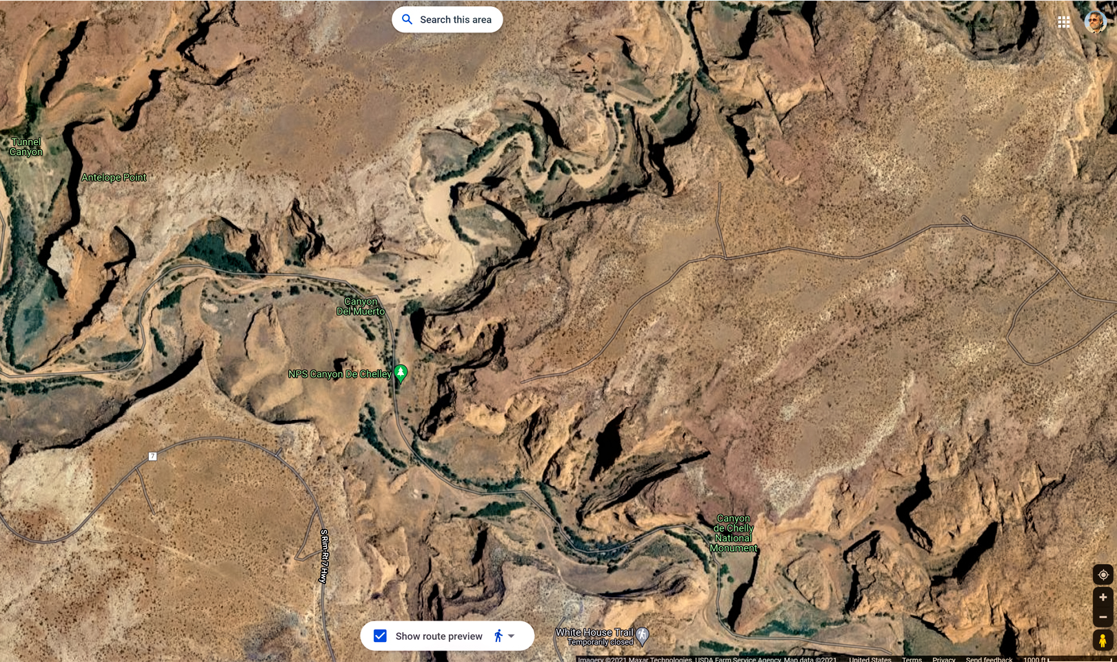
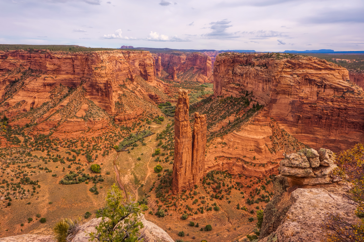
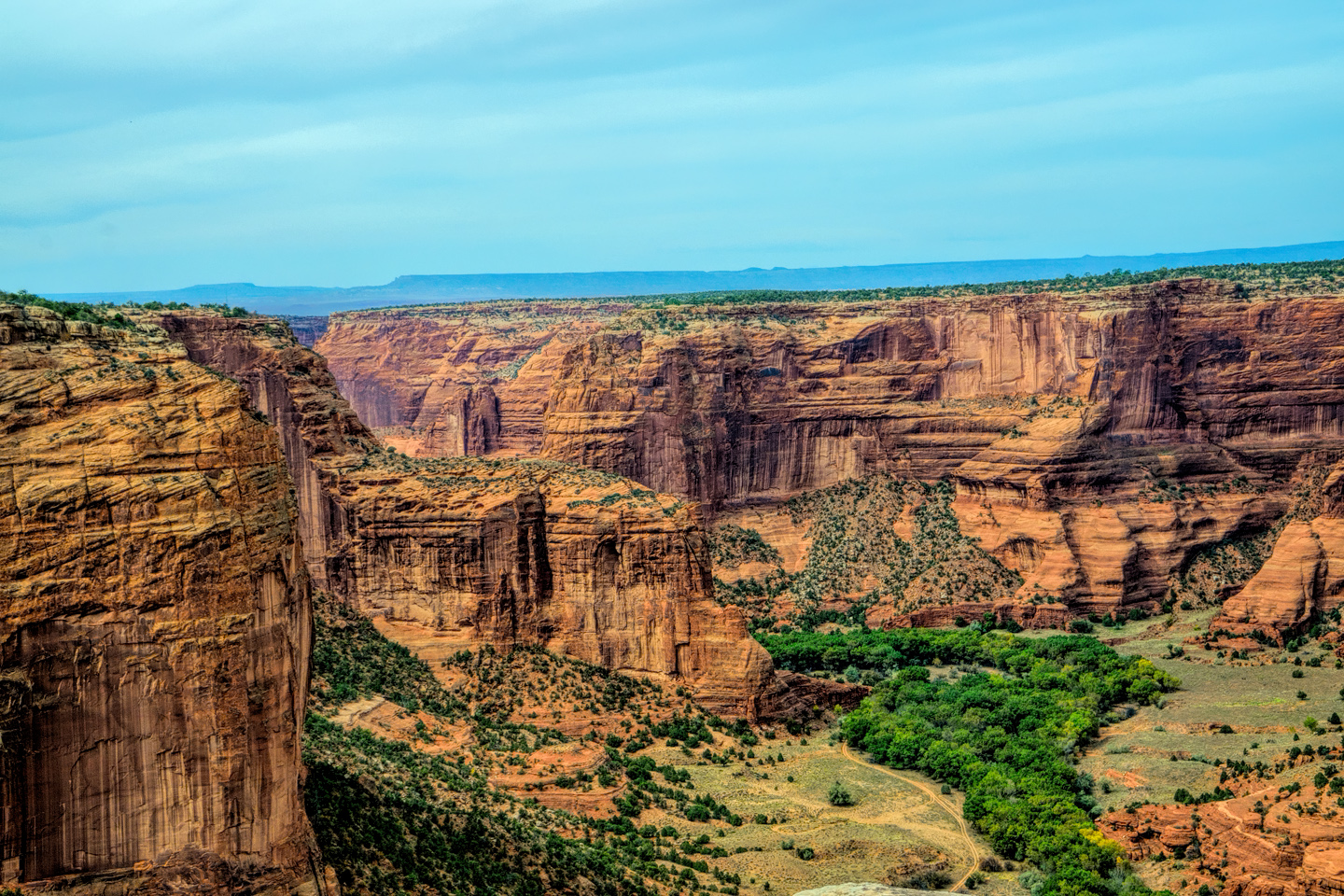
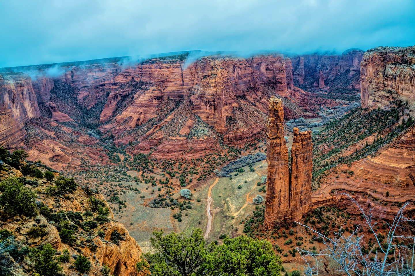
The right hand fork is Canyon de Chelly, Tseyi to the Navajo, the branch of the canyon for which the National Monument was named. Canyon de Chelly is where you’ll find both the White House Ruin and Spider Rock, the park’s best known attractions, but Spider Rock is at the end of a long road, a 22 mile round trip from the Junction, so only the longer tours go out that far. (I describe that route in the final post of this series: Canyon de Chelly: Part 4: The Road to Spider Rock).
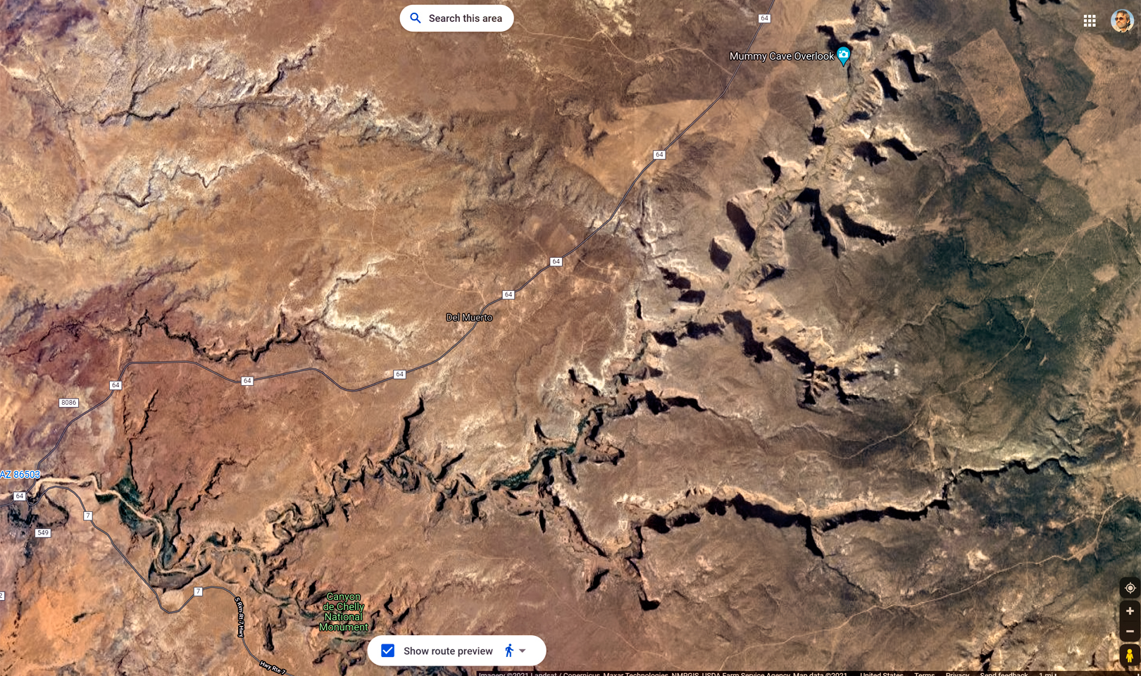
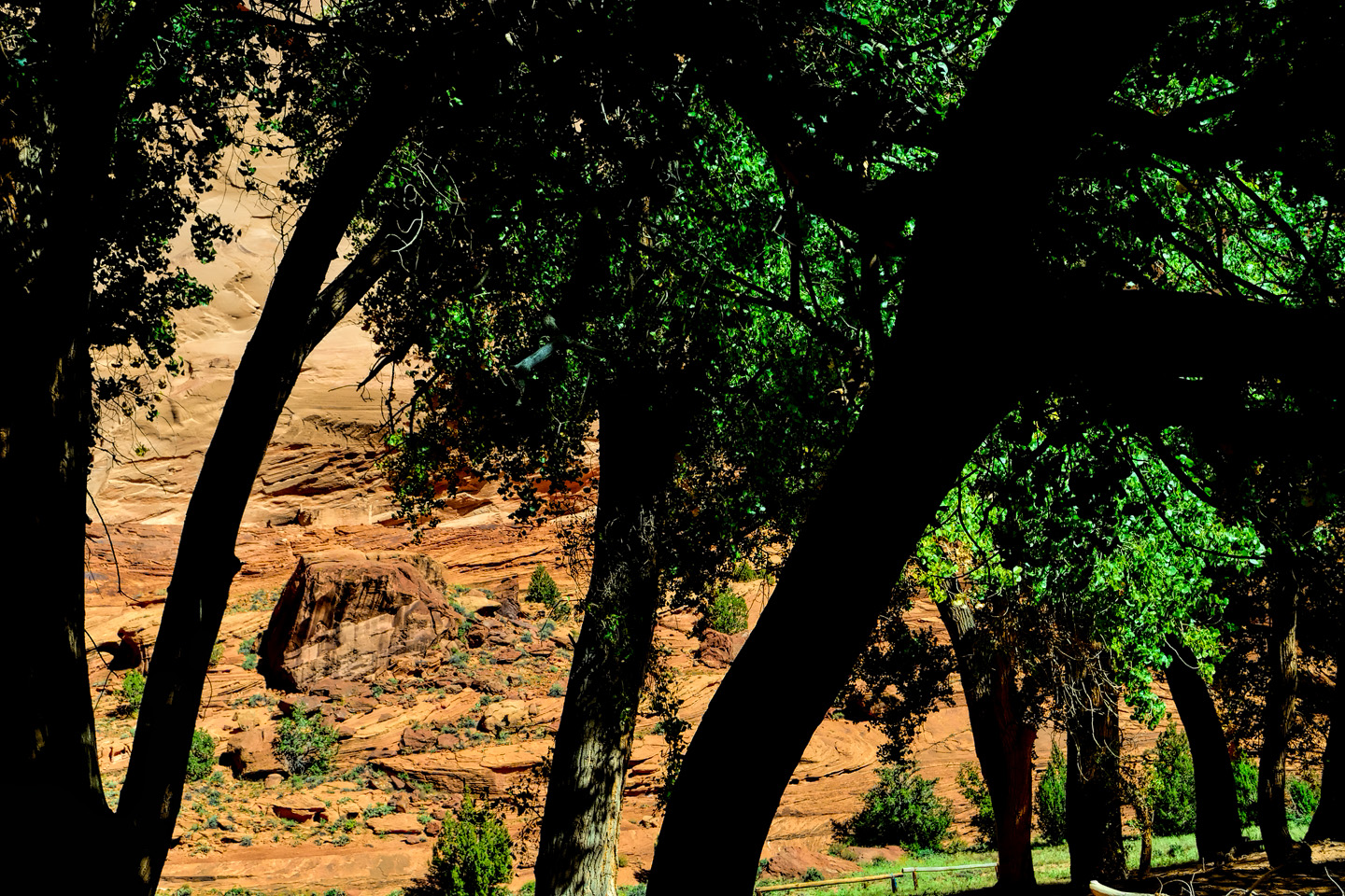
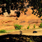
The left hand fork is the spectacular work of nature known as Canyon del Muerto. The star attraction of this route is the Mummy Cave Ruin, the largest in the area, built on a ledge between a pair of deep caves, high on the face of a cliff in an extraordinary natural amphitheater. It’s a 24 mile round-trip from the Junction, twelve miles of rough road in each direction, with enough twists and turns to qualify as a carnival ride–along with plenty of mud! Along the way you pass the Ledge Ruin, Antelope House Ruin, Navajo Fortress, and Standing Cow Ruin, along with some extraordinary rock art.
Click on maps and photos to expand them to full screen
CANYON DE CHELLY TOUR OPERATORS
NAVAJO NATION PARKS AND RECREATION
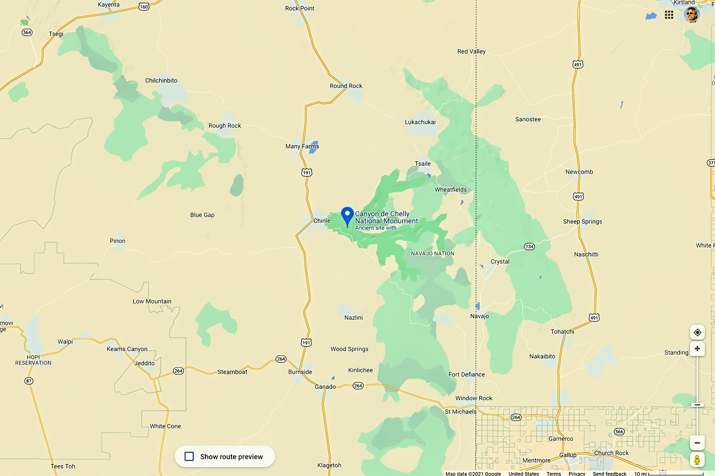
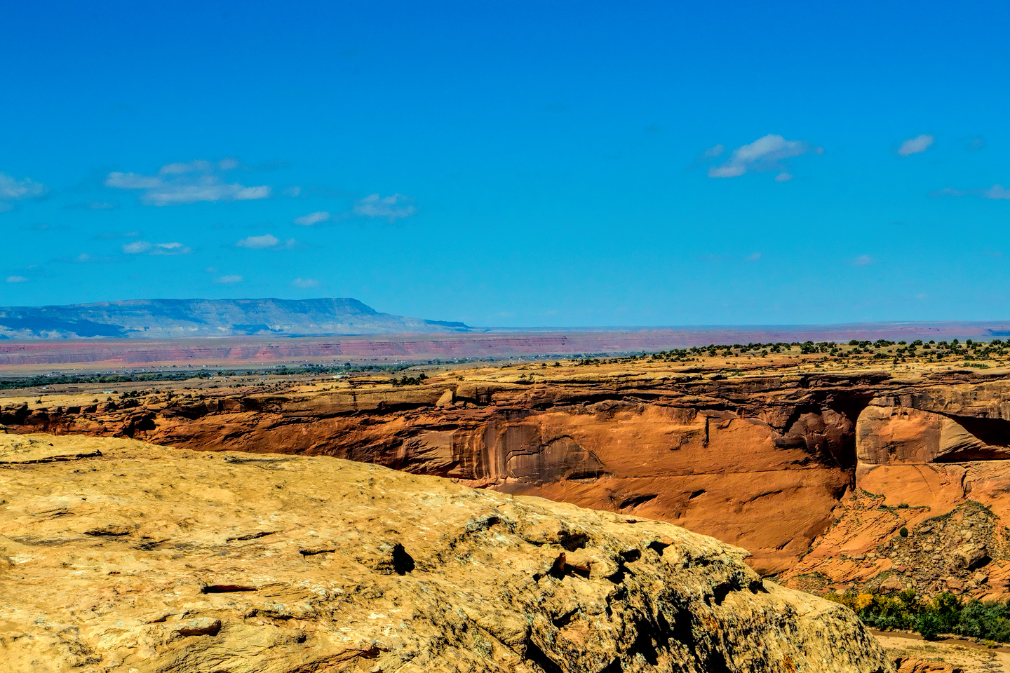
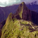
Canyon de Chelly National Monument was established in 1931, to protect and preserve an area totaling 131 square miles, including three major canyons: Canyon de Chelly, Canyon del Muerto, and Monument Canyon. In addition to spectacular rock formations that can be seen from the overlooks along the rim, these canyons are a living museum that holds the ruins of cliff dwellings and panels of rock art, more than a thousand documented archaeological sites representing 5,000 years of human occupation, by a succession of at least five native cultures.
The National Monument is located entirely within the borders of the Navajo Nation, and most of the land on the floor of the canyons is privately owned by tribal members, who continue to grow crops and raise livestock on family plots. With the single exception of the White House Trail and the White House Ruin, visitors are not allowed to venture anywhere below the canyon rim without an authorized Navajo guide.
(Click the link above for a current list)
The most popular tours last between 3 and 4 hours. Most of them travel into both canyons, but don’t go all the way to the end of either road. Only the longer tours include Spider Rock or Mummy Cave, and only the all day tours include both. Private tours offer the most flexibility, and in most cases, a more comfortable ride.
I spread my own visit across three days, allotting a full day for the rim drives (including the hike to White House Ruin), another full day in Canyon del Muerto, followed by a half day in Canyon de Chelly. If you want to see the whole spectrum of what this remarkable place has to offer, that’s a strategy that I can personally recommend!
Into the Canyon of Death: Scenes along the Road to Mummy Cave
With all of the stops we made, it had taken us more than two hours to travel the 3½ miles from the beginning of the canyon, up Chinle Wash to the junction. Our guide, Sylvia Watchman of Arizona Canyon Jeep Tours, was born and grew up on her family’s land in Canyon del Muerto, so she was sincerely looking forward to this next leg of our journey.
“Most visitors don’t go all the way up Canyon del Muerto,” Sylvia explained, “because it takes too much time. Since you guys want to spend two whole days in the canyons, I’ll get to show you all my favorite places.”
“Why do they call it Canyon del Muerto?” I asked. “I’m sure you know what that means in Spanish!”
“Of course,” she replied. “Canyon of the Dead. That’s because of the mummies they found buried by the Mummy Cave. But Massacre Cave is here as well; that’s the place where a lot of Navajo people were killed by Spanish soldiers. You could say there has been a lot of death here, but a lot of life as well.”
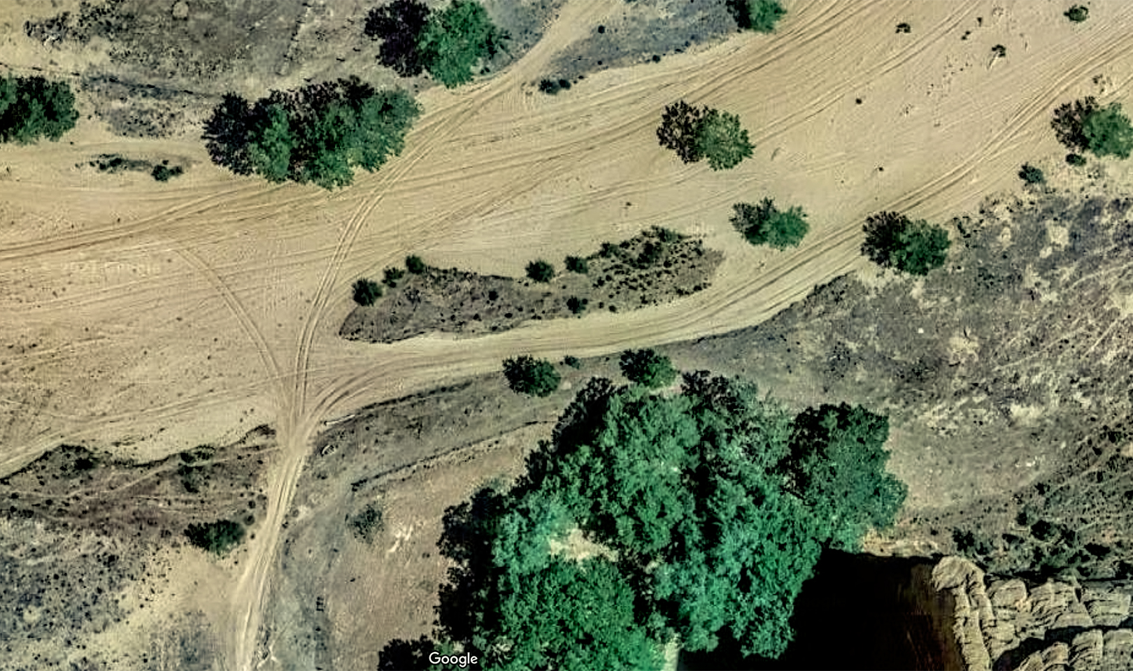
We drove away from the junction, bearing left at the fork, and followed tire tracks that ran down the middle of the sandy stream bed. After a short distance, perhaps half a mile, Sylvia told me to pull over on the left, and we all got out again. She led us through a stand of trees to a place where we had a clear view of a sandstone wall. I could see a row of pictographs, painted images, running upward at an angle, just above a small square structure built from what looked like sandstone or adobe blocks.
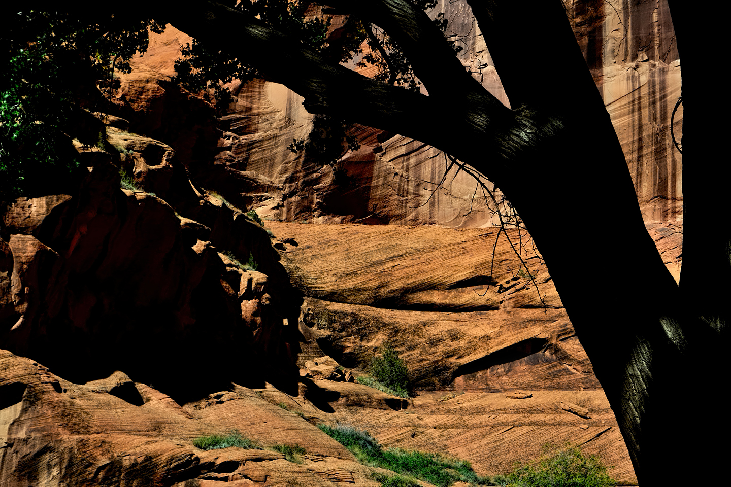

BIG HAND RUIN
“This is Big Hand ruin.” said Sylvia. “That’s a storage bin; and there are a lot of birds. Right here is the big hand, the man with the big hand. The pictograph is drawn as a man with big hands.”
“Now, you know, nowadays you always hear about big foot, and stuff like that? There’s probably a drawing of it somewhere right in here.”
We all got a chuckle out of that, but the more I thought about it later, I realized she might have been serious!
Click any photo to expand the images to full screen
To continue reading the post, click the button below:
Disclaimer: the narrative in this post includes dialogue attributed to my Navajo friend Sylvia Watchman, who was our guide on a two-day tour of Canyon de Chelly in October of 2013. The dialogue in the post is based on the transcript of an audio recording made two years later, when I visited Sylvia in Chinle, and we reviewed my photos from the trip. There was minor editing for grammar and continuity. I take full responsibility for any errors or omissions.
Unless otherwise noted, all photographs on this site are my original work, and are protected by copyright. They may not be duplicated for commercial purposes.
MORE ABOUT CANYON DE CHELLY:
The Most Beautiful Place on Earth:
A Guide to Canyon de Chelly National Monument
This is an interactive Table of Contents. Click the pictures to open the pages.
Canyon de Chelly: Part 1: The Rim Drives

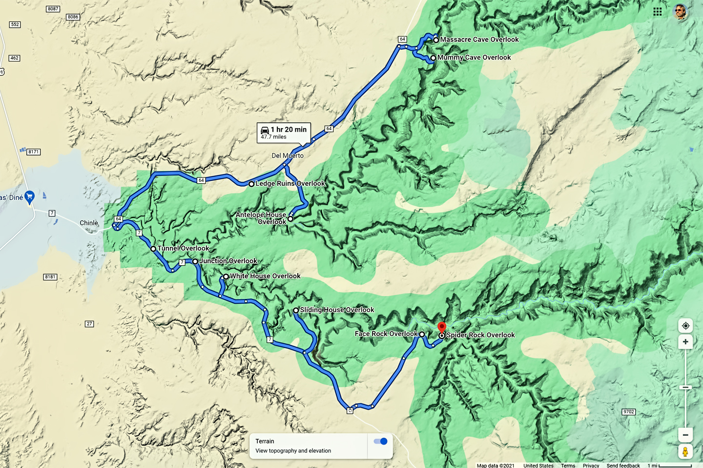
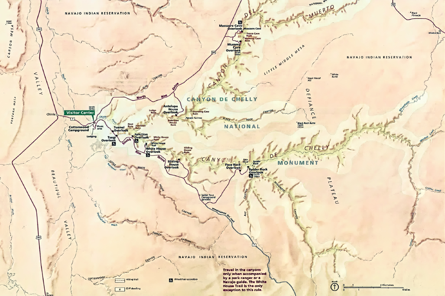
Most of Canyon de Chelly can only be seen by visitors who are accompanied by an authorized guide, but the Rim Drives are free of charge, no reservation required. Two roads, Indian Route 7, and Indian Route 64 diverge at the entrance to Canyon de Chelly National Monument. Route 7 follows the South Rim of the multi-pronged formation, providing access to seven overlooks, all with killer views into Canyon de Chelly. Route 64 follows the North Rim, and provides access to three more overlooks, with excellent views into the branch known as Canyon del Muerto.
The South Rim drive is a 36 mile round trip, from the Welcome Center to the Spider Rock Overlook and back again, making multiple stops in between. You’ll need a couple of hours to do it justice, depending on how much time you spend at each of the different overlooks. The North Rim drive is shorter, just over 26 miles round trip to the Mummy Cave Overlook. That drive requires another hour and a half, bare minimum, so if you’re going to do both, you should play it safe, and set aside half a day. I can guarantee you’ll consider it time well spent! <<CLICK to Read More!>>

The South Rim Drive
Indian Route 7 begins at the turnoff from US 190, and serves as the main road in the Navajo town of Chinle. If you follow it headed east, it will take you directly to the Visitor Center for the Canyon de Chelly National Monument. Stop there to pick up a map of the park, and to get current information about guided tours and other activities, as well as road conditions, and any closures that might affect your visit.
From the Visitors Center, bear right at the fork to stay on Indian Route 7, the South Rim Drive, and follow the signs to the overlooks.
<<CLICK to Read More!>>

Overlooking the White House
A mile and a half beyond the Junction Overlook you’ll reach the turnoff for the White House Overlook, which is at the end of a half-mile long access road. The White House Overlook has always been one of the most popular. The vantage point offers a fabulous panorama of the Canyon, along with an unobstructed view of the White House, one of the best preserved ruins in the National Monument.
<<CLICK to Read More!>>

The North Rim Drive
Most visitors to Canyon de Chelly National Monument focus the bulk of their attention on the South Rim Drive, but in my view, your trip simply won’t be complete if you don’t take in the North Rim Drive as well.
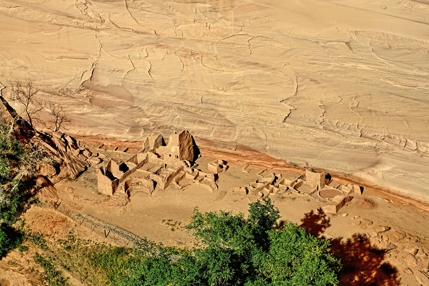
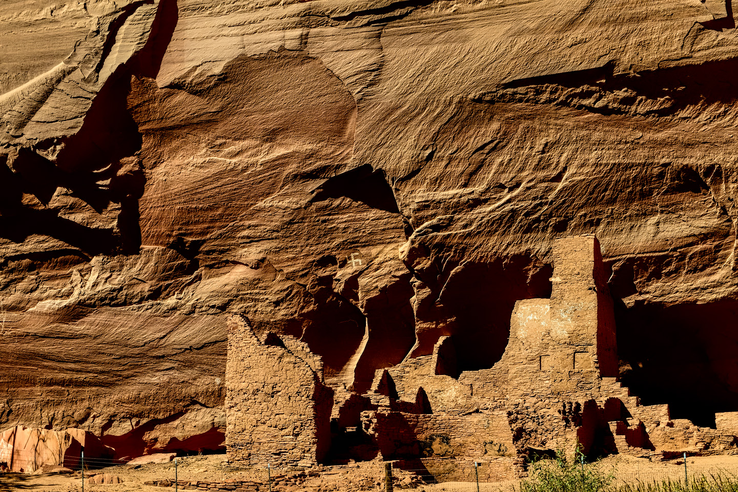
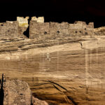
Seven miles from the Welcome Center is the turnoff to the Antelope House Overlook, which is two miles further along a paved access road. The payoff is a fabulous bird’s-eye view of a quite wonderful Anasazi ruin known as the Antelope House. You can still see the crumbling foundations of dozens of rooms, a tower, and at least four circular kivas…
<<CLICK to Read More!>>
Canyon de Chelly: Part 2: Chinle Wash

Canyon de Chelly National Monument is a place for the whole world to enjoy and admire, just like all of our national parks and monuments, but at Canyon de Chelly there is an essential difference: the rim drives and most of the overlooks offering views into the beautiful canyon are open to the public all year around. The canyon itself, including all hiking trails and Jeep tracks, all the ruins and the rock art, in essence, anything below the canyon rim, all of that is private property, off limits to everyone save the handful of Navajo families who own the land on the canyon floor.
The rest of us can go in, but only to certain areas, and only if we’re accompanied by an authorized guide. A Navajo guide can take you into the canyon in their SUV, or, if you prefer, you can join a guided hike, or a trail ride on horseback. The standard Jeep tours, which are the most popular, range from three to six hours in length. The longer tours cover the highlights of both of the primary gorges, Canyon De Chelly, and Canyon del Muerto.
The series that follows is a detailed account of my own experience in this remarkable place. <<CLICK to Read More!>>

A Timeless Journey into the Heart of the Navajo Nation
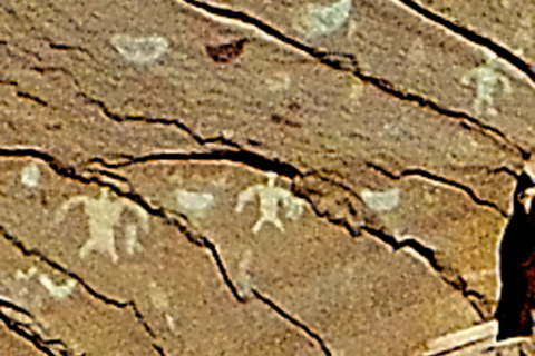
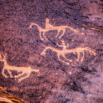
At the beginning of our trip, we asked Sylvia to show us her favorite petroglyphs, along with the usual ruins and rock formations, and she did not disappoint. Our first stop, very near the mouth of the canyon was a prehistoric bulletin board she called Newspaper Rock. A smooth segment of cliff face coated with dark desert varnish, featuring an area at least forty feet wide filled with hundreds of petroglyphs. The symbols weren’t carved into the rock, and they are not painted. These artists pecked away the dark varnish, creating their pictures by exposing the lighter colored rock underneath: antelope, birds, hunters, and a multitude of intriguing symbols.
<<CLICK to Read More!>>

Ancient Stories Etched in Stone
A short distance from Newspaper Rock, just a few steps away along the base of the cliff, we came to another set of petroglyphs featuring riders on horseback. These were most certainly Navajo, and likely date back to the 1800’s. They shared this shady space with other images that were obviously much older. There were hunters, deer, birds, handprints, and more. We crowded in close for a better look.
<<CLICK to Read More!>>

Kokopelli and the Lightning Spear
“When you look at this, there’s a man holding a staff; out of the staff there’s this energy that’s coming out. The figure in black is the patient. The one in yellow is the shaman. The important men of the village are up on the side here, so this was a very sacred ceremony that they were doing. And there are some other drawings on the side; this one here is like a figure of the holy people, because it’s way up there, and it only has the head, and not the arms or the legs. You see a lot of people drawn, and there’s a bird there. And these are drawings of, like, clan systems. The bear, the turtle, and the antelope down here.”
I was probably getting a bit starry-eyed at that point. Barely three miles into the canyon, we’d traveled a thousand years in just under a hundred minutes, and we were barely even underway!
<<CLICK to Read More!>>

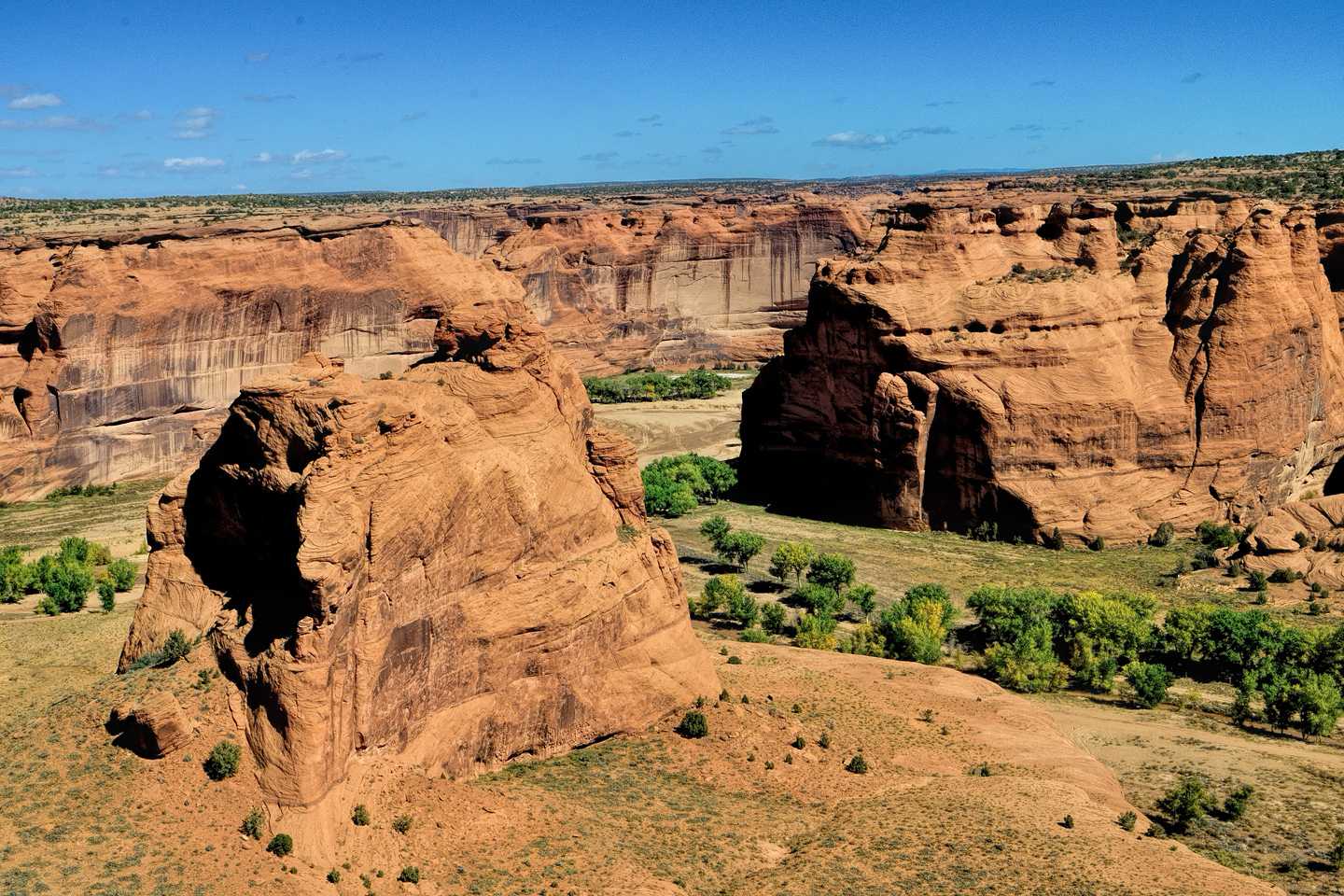
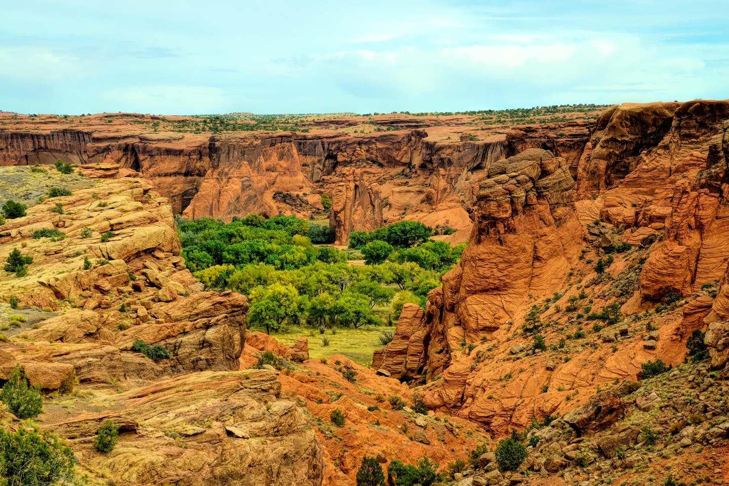
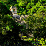
Where Canyons Collide
Just around the bend the canyon opened up into an area wider than any other we’d seen, and right in the middle was a monolithic block of sandstone known as Dog Rock. To the left was the north fork of the canyon, Canyon del Muerto, and to the right, the south fork, Canyon de Chelly itself. The cliffs soared at least 200 feet above our heads, and halfway up the sheer face opposite was another alcove filled with crumbling adobe, a site called Junction Ruin. A bit smaller than First Ruin, and a bit less well preserved, this is an Anasazi structure dating to the same approximate era. The ruin is clearly visible from above at the Junction Overlook on the South Rim Drive; it looks a bit different when viewed from below…
<<CLICK to Read More!>>
Canyon de Chelly: Part 3: Canyon del Muerto

The left hand fork is the spectacular work of nature known as Canyon del Muerto. The star attraction of this route is the Mummy Cave Ruin, the largest in the area, built on a ledge between a pair of deep caves, high on the face of a cliff in an extraordinary natural amphitheater. It’s a 24 mile round-trip from the Junction, twelve miles of rough road in each direction, with enough twists and turns to qualify as a carnival ride–along with plenty of mud! Along the way you pass the Ledge Ruin, Antelope House Ruin, Navajo Fortress, and Standing Cow Ruin, along with some extraordinary rock art.
The most popular tours last between 3 and 4 hours. Most of them travel into both canyons, but don’t go all the way to the end of either road. Only the longer tours include Spider Rock or Mummy Cave, and only the all day tours include both. Private tours offer the most flexibility, and in most cases, a more comfortable ride.
<<CLICK to Read More!>>

Ruins and Rock Art
In this pictographic sequence, the Utes are on the left, mounted on horseback, with shields and lances, while the Navajos are on the right, on foot, and clearly outnumbered. In one version of the story, just as in Sylvia’s account, the attack took place during a Night Way healing ceremony, in the winter, catching the Navajo by surprise, and at a deadly disadvantage.
The drawings are charcoal, except for the shields, which were painted with pigment made from the bee weed plant. The sandstone overhang provides some protection, but after 150 years or more, the panel is weathering, starting to fade and flake away. Many of the rock art panels in these canyons are in danger of irreversible deterioration from exposure to the elements. Pictographs such as these, done with charcoal and other natural pigments, are particularly vulnerable to the ravages of time.
<<CLICK to Read More!>>

Antelope House
Antelope House was formally excavated in the early 1970’s, by archaeologists working with the National Park Service. Each new culture that occupied this site built atop the remains of their predecessors, so as researchers dug into the stratified foundations, they found the pit houses of the Basket Makers at the bottom, and layers of increasingly sophisticated cultural remains, from the Ancestral Pueblo to the Pueblo people, the Hopi, and the Navajo, each of these groups contributing to the timeline of an area that is exceptionally rich in history.
Of all the ruins and other archaeological sites in Canyon de Chelly, Antelope House is the most thoroughly investigated. That’s at least partially due to simple ease of access: unlike most of the ruins in the canyon, all the primary structures at this site are at ground level.
<<CLICK to Read More!>>

Standing Cow: A Home Among the Ruins
The hogan, much newer than the other structures, was built using sandstone bricks recycled from the surrounding ruins. That would never have been allowed today, but at the time, before the National Monument was established, there weren’t any rules against it, so Sylvia’s great grandfather was simply being practical, using what was available. Today, Standing Cow is on all the maps, as much a part of the human landscape of Canyon de Chelly as the White House and the Mummy Cave. We felt quite privileged to be there with someone who was so directly connected to all of it.
<<CLICK to Read More!>>

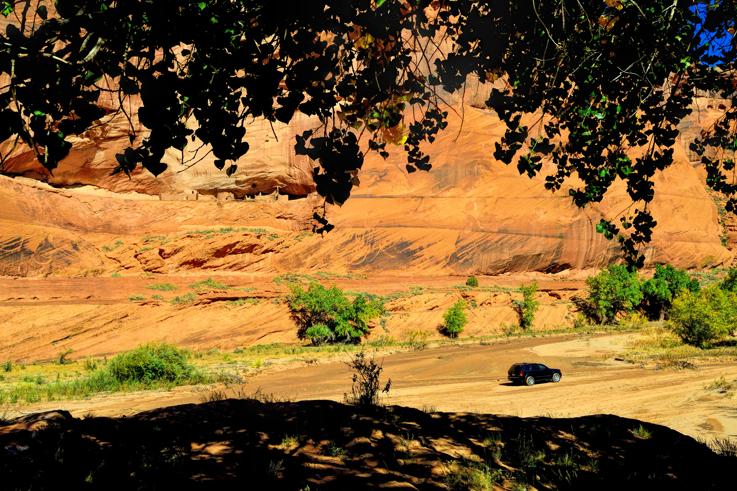
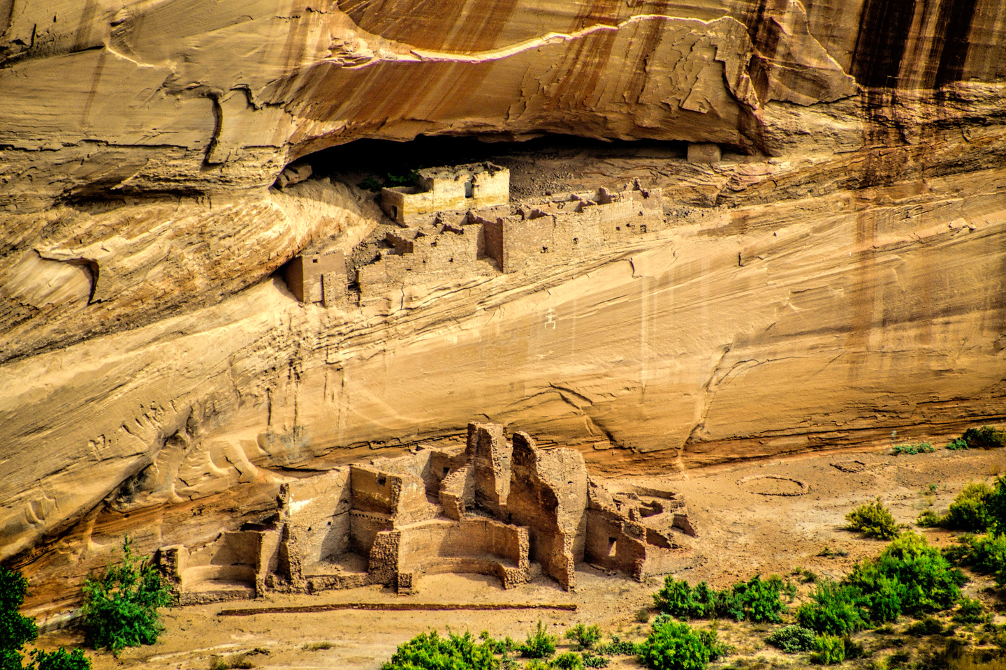
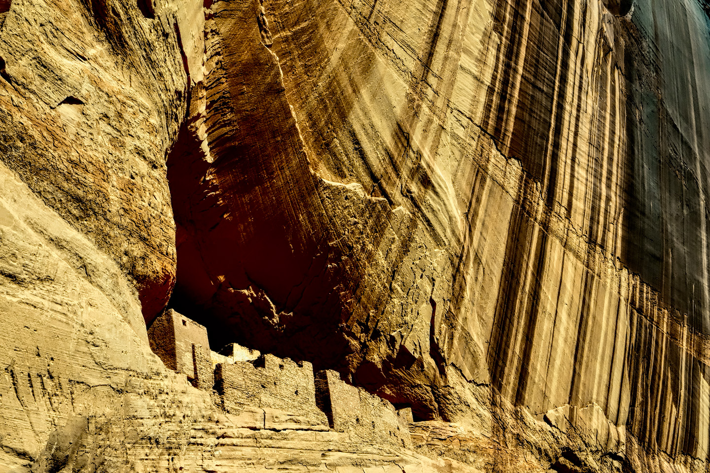
Blue Bull and Mummy Cave
300 feet above the canyon floor, there are two deep alcoves filled with ruins, and on a wide ledge between them, a large, multi-story pueblo, partially reconstructed, and quite impressive. The setting is a natural amphitheater, and the overall aspect of the place is simply stunning.
Occupied for a thousand years, from around 300 A.D. until 1300 A.D. The whole complex, including the main building and the structures in the two flanking alcoves had as many as 70 rooms, including living quarters, ceremonial spaces, and storage.
<<CLICK to Read More!>>
Canyon de Chelly: Part 4: The Road to Spider Rock

Today, only authorized Navajo owned vehicles are allowed inside Canyon de Chelly, but this was in 2013, when it was still possible to drive yourself in your own 4×4, as long as your Navajo guide rode along with you. That arrangement was Sylvia’s specialty, and driving through that canyon, with her ongoing expert narrative providing background on all the points of interest, was some of the best fun I’ve ever had.
The first part of the route was aleady familiar to me. We entered Chinle Wash from that same dirt road, just past the Visitor’s Center, and I took off down the sandy creek bed, keeping up a steady speed and zig-zagging diagonally across the deepest ruts, to avoid getting trapped.
We passed by all the places where we’d stopped the day before, and made it all the way to the junction in just over half an hour. This time, we took the right hand fork, and we hadn’t gone far when we ran into our first big challenge of the day: a steep downslope that crossed a wash, with deep mud at the bottom of the hill.
<<CLICK to Read More!>>

Riding the Rainbow to the Universe
Viewing Spider Rock from below provides a dramatically different perspective on this extraordinary formation. From above, you’re looking down on the whole tableau, and Spider Rock, shorter than the soaring canyon walls, appears as one small part of the larger scene. From below, from the floor of the canyon looking up at it, you can see just how BIG the danged thing is. At 800 feet in height, it’s a good bit taller than your average 50 story sky scraper, and it completely dominates the landscape.
<<CLICK to Read More!>>

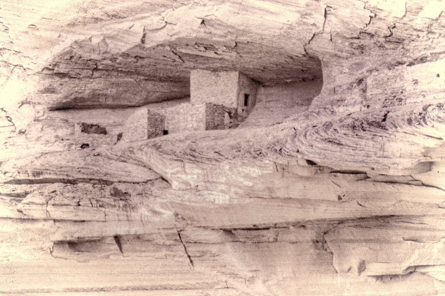
The Oldest White House
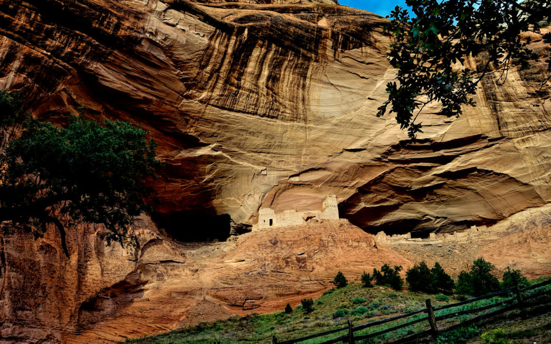
At the center of the upper section is a large room, 12 by 20 feet, with a front wall that is 12 feet high and made of stone that is two feet thick. This wall was coated in white plaster, decorated with a yellow band, and it is this white wall, which can still be seen, that inspired the name La Casa Blanca, the White House, to this ancient dwelling that has endured in this place for nearly a thousand years.
<<CLICK to Read More!>>
YOU MIGHT ALSO ENJOY:

San Xavier del Bac: The White Dove of the Desert
San Xavier has all of the traditional elements of a Spanish Colonial church, along with many others that are quite unique. The craftsmanship of the original building is superb, and features many fascinating details.
<<CLICK to Read More!>>

A Serendipitous Sunset at Shiprock
I noticed an odd rock formation coming up fast on the left side of the road, almost like a wall built of angular blocks. Shiprock was close, but hidden from view by the wall as I zoomed toward it. After I passed the odd formation, I stole a quick glance in my rearview mirror, and what I saw was a scene so other-wordly, it literally stopped me in my tracks!
<<CLICK to Read More!>>

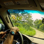
There’s nothing like a good road trip. Whether you’re flying solo or with your family, on a motorcycle or in an RV, across your state or across the country, the important thing is that you’re out there, away from your town, your work, your routine, meeting new people, seeing new sights, building the best kind of memories while living your life to the fullest.
Are you a veteran road tripper who loves grand vistas, or someone who’s never done it, but would love to give it a try? Either way, you should consider making the Southwestern U.S. the scene of your own next adventure.
A few years ago I wrote a book about road trips in Arizona and New Mexico that’s a lot like this website, packed with interesting information, and illustrated with beautiful photographs. Check it out! You can find it on Amazon, and at all other major booksellers.

ALASKA ROAD TRIP:
MEXICAN ROAD TRIP (IN THE LAND OF THE MAYA):
ARIZONA AND NEW MEXICO:
SOUTH AMERICA:
PHOTOGRAPHY:


0 Comments