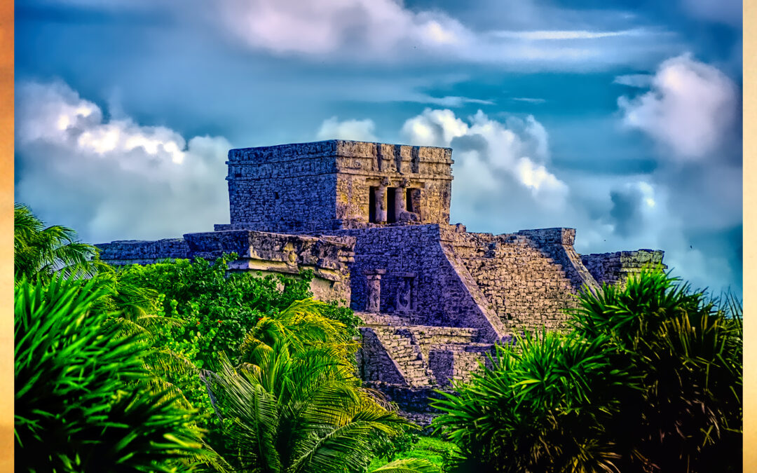
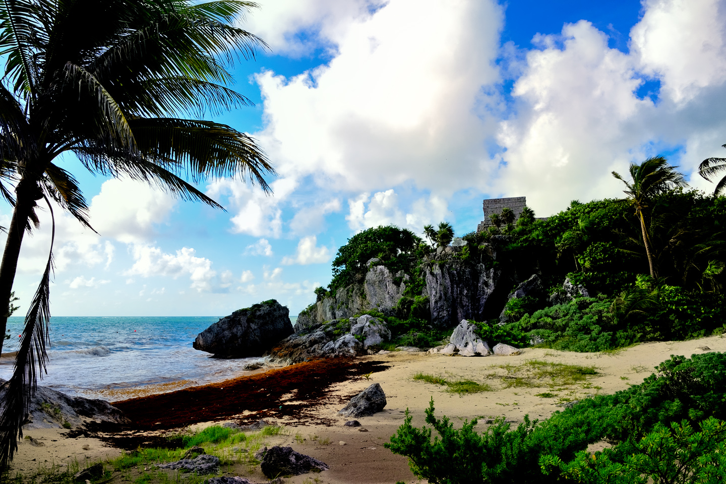
Tulum is not all that large, as Mayan cities go, but its spectacular location, right on the Caribbean coast of the Yucatan Peninsula, makes it one of the best known, and definitely one of the most picturesque. This was a late post-classic Maya site that was at it’s peak from 1200 AD right up to the time of the Spanish Conquest. It was still inhabited for at least 70 years after the arrival of the Europeans, until the Old World diseases brought along by the Spaniards took hold and decimated the population, causing the town to be abandoned.

Today, the ruin is home to a motley assortment of Spiny Tailed Iguanas, and if you visit when it’s busy, to brightly colored herds of tourists, taking a day trip from Cancun, or one of the many other resorts along the Riviera Maya. Tulum is easily accessible to the millions of beach loving vacationers that come to the area every year, and that, more than anything else, makes it one of the most popular Mayan ruins in the Yucatan, second only to the famous ancient city of Chichen Itza. 

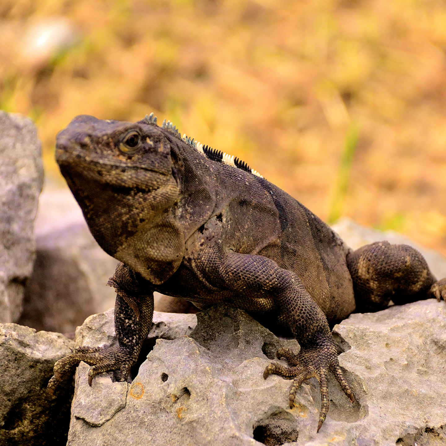
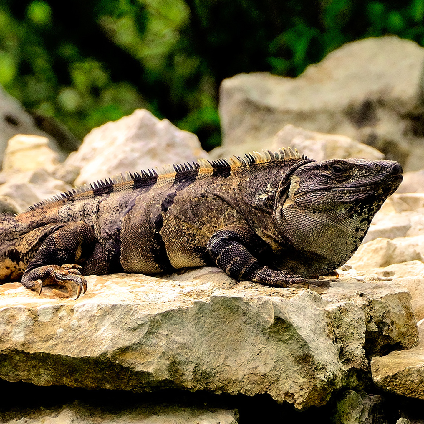
Iguanas take over when the tourists depart, so the abandoned city is never entirely empty.

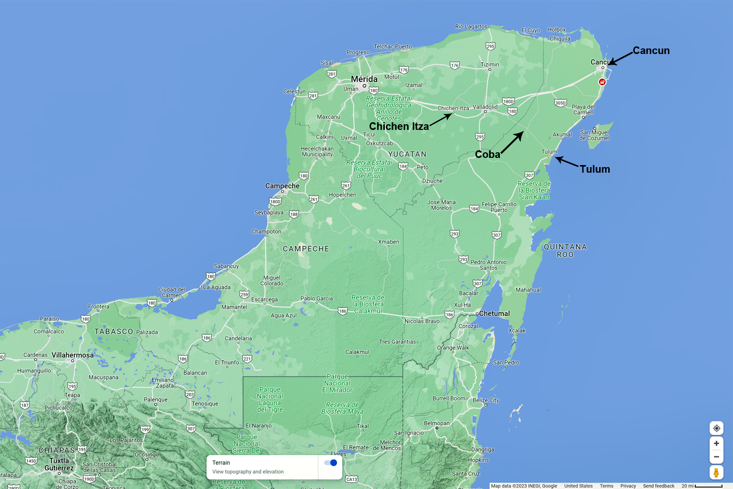
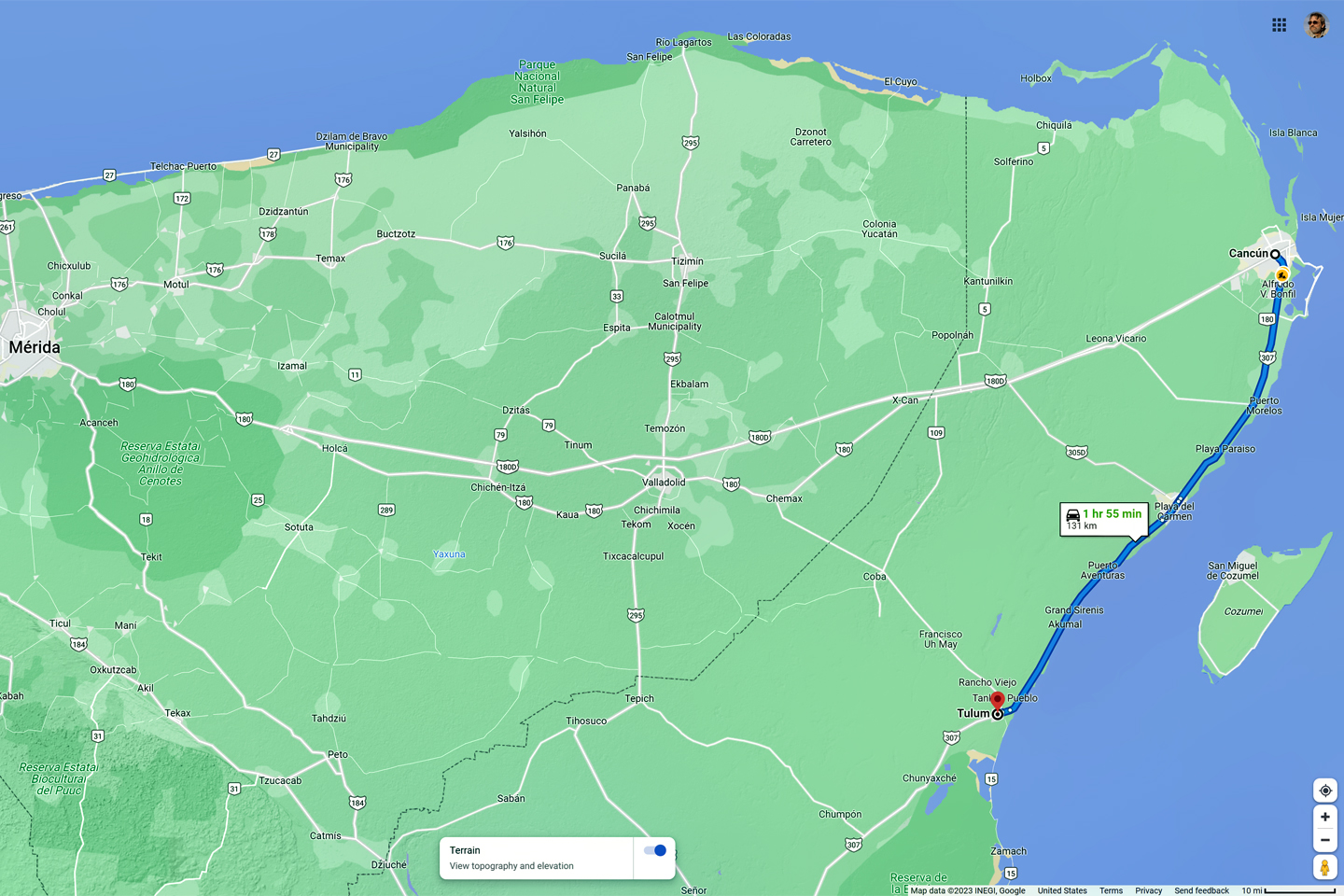
The location of Tulum, relative to Chichen Itzá, Cancun, and Coba

Click maps and photos for an expanded view 

HISTORY OF TULUM

In the Yucatec Mayan language, Tulum means enclosure, or wall, but scholars believe that’s a modern name. It’s thought that the original name may have been Zama, which means dawn, in reference to its location on the eastward facing coast. Tulum was in fact a walled city, built for easy defense, perched on ocean-side cliffs nearly forty feet high. This fortress-like town of perhaps 1500 inhabitants served as the port for Coba, a much larger Mayan center that lay inland, 27 miles to the northwest. There was a significant volume of coastal trade in the ancient Americas. Large seagoing canoes followed routes that hugged the coastline from the Gulf of Mexico, around the Yucatan Peninsula to the Caribbean.

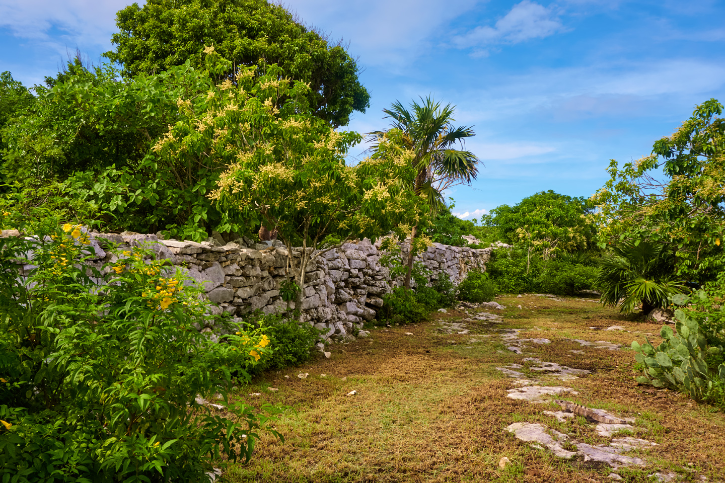
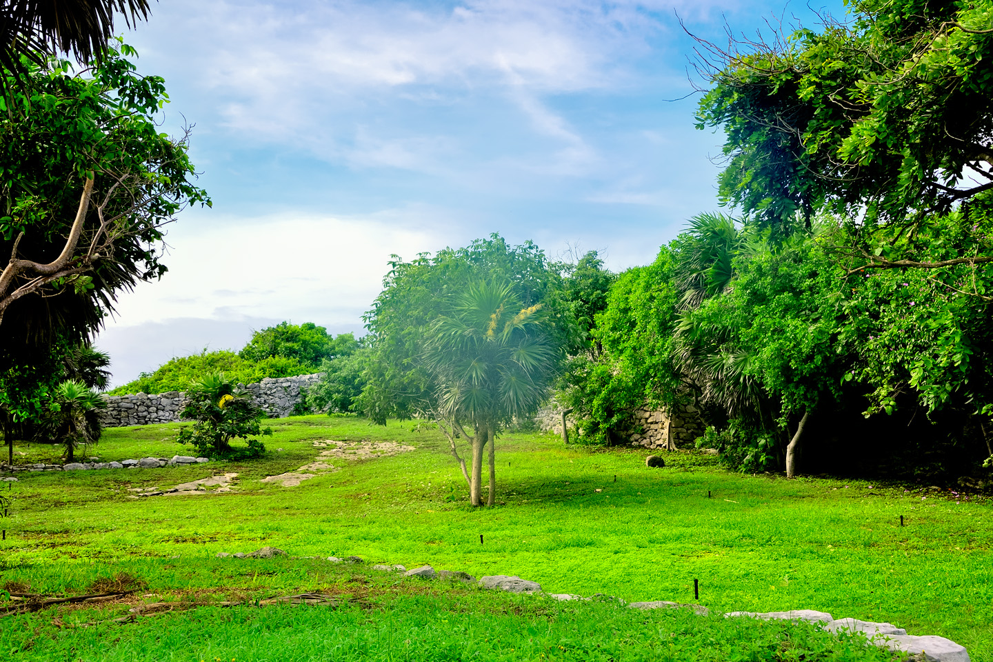
A reconstructed section of the boundary wall that once surrounded the city of Tulum, keeping out any invaders, and separating the common people from the elite: the nobles, priests, and wealthy merchants.

The traders carried mostly low density, high value trade goods, things like jade, turquoise, and feathers from rare birds, as well as more utilitarian items like salt, obsidian, and honey. Dried cacao pods were a special commodity, often used as a form of currency. There was also trade in ideas, construction techniques, and artistic styles, which helps to explain some of the similarities between disparate cultures that were separated by significant distances.

PIRATES OF THE CARIBBEAN

Tulum was one of many ports and trading centers serving the vast territory of the ancient Maya. The elite class of nobles and priests who ruled those lands had an abiding fondness for the finer things, so the trade in such items was brisk, and quite lucrative. Without wheels or pack animals, anything transported over land had to be packed on the backs of porters. Such men braved significant hardships, crossing rugged mountains and dense jungles, fording rushing rivers, and defending themselves from any hostiles who might attempt to hijack their cargo.

The coastal trade routes were much more efficient, as they used large, seagoing canoes with as many as a dozen paddlers, capable of carrying far more weight over greater distances. Ports like Tulum became storehouses as well as distribution points for the elite luxury goods that arrived in a steady stream. Whenever significant wealth is concentrated in one spot, it tends to bring out the worst in human nature, so before long, it became necessary to fortify the larger trading centers. Tulum was protected by forty foot cliffs on the seaward side, and by a wall that surrounded the rest, so the defenders had a decided advantage against any attackers.

The trading canoes that carried valuable cargoes were defended by warriors armed with the weapons of the day, but a boatload of men with spears is far more vulnerable than a walled city defended by well-prepared fighters. There is no direct evidence of seagoing piracy during the Mayan era, but the temptation would have been hard to resist, and the fact that the canoes are so often depicted with guards is a good indication of an ongoing threat. Pretty cool, when you think about it. The original Pirates of the Caribbean were almost certainly Mayans, and if so, they would have predated Captain Jack Sparrow by half a millenium!

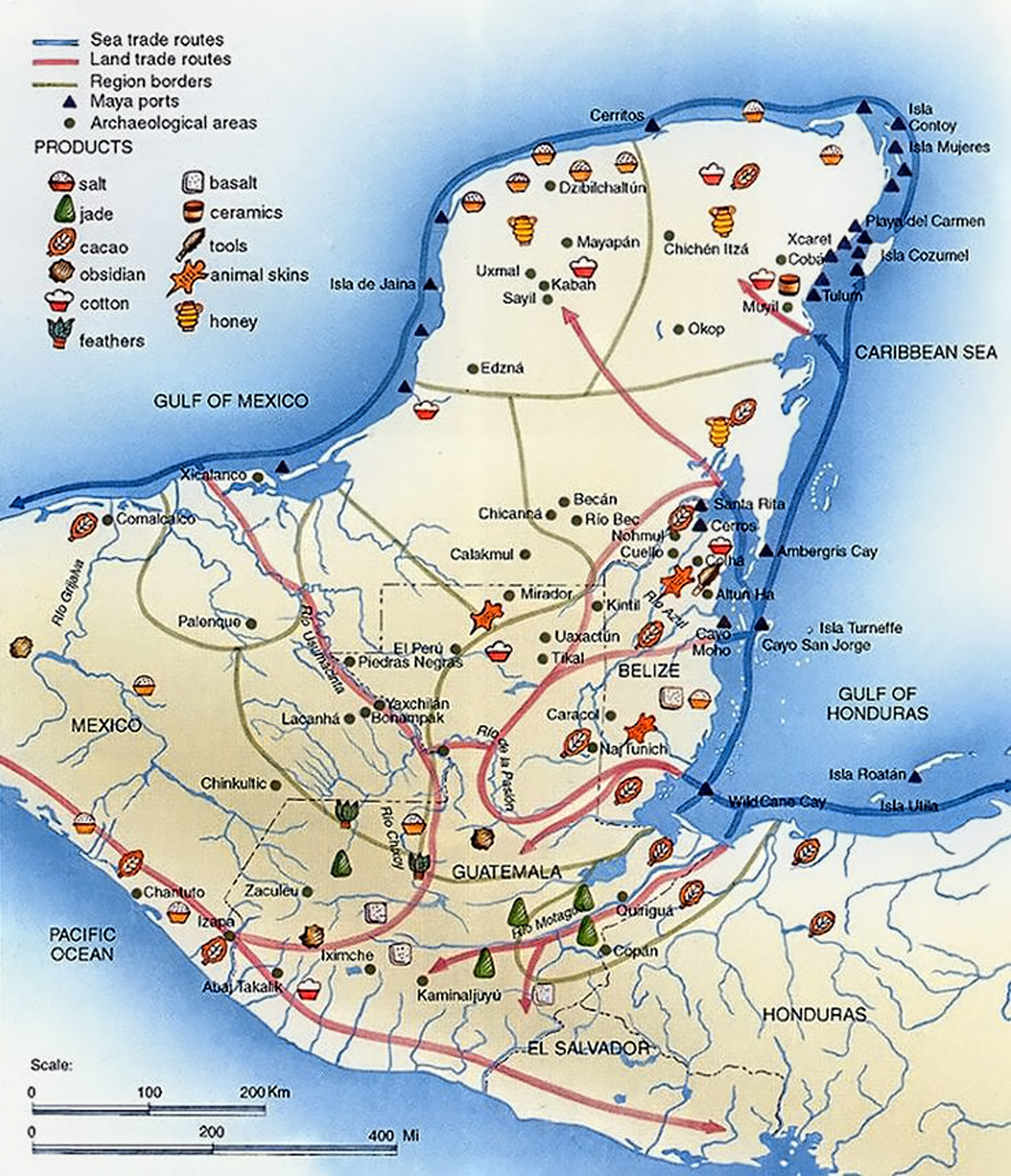
Mayan trade commodities, and the routes followed by traders on both land and sea. Coastal trade was by far the most efficient.

It is commonly believed that the port cities were controlled by the larger Mayan centers that lay further inland; that the nobles in charge of Tulum, for example, were underlings, subservient to the Lords of Coba. According to one theory, the trade wasn’t really trade at all, because everything went in one direction, like a pipeline that supplied, not water or oil, but luxury goods, all bound for a single destination. According to another theory, the coastal Maya were an entirely different people than the inland Maya, historically, culturally, even physiologically, and that they controlled the flow of trade, ultimately for their own benefit. The trading relationship between the ports and the inland cities is well documented; what’s not entirely clear is the pecking order. Who was actually in charge?

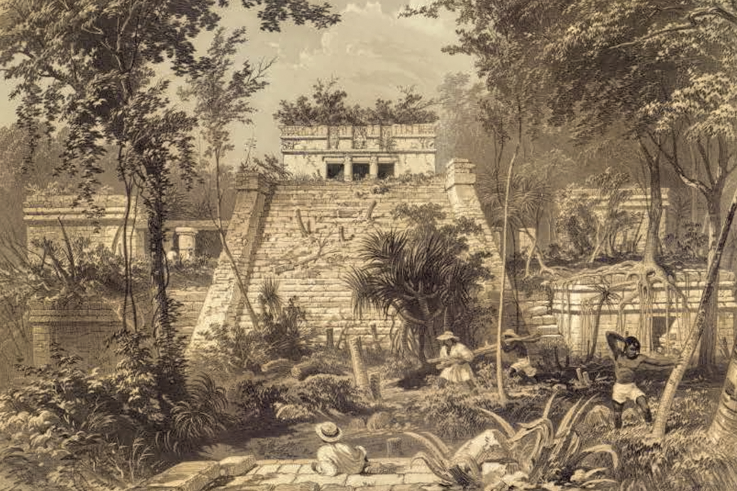
The Castillo at Tulum, an illustration by Frederick Catherwood from the book, Incidents of Travel in Yucatan. The drawing shows workmen in the process of clearing off the building, as it would have apeared in 1841.

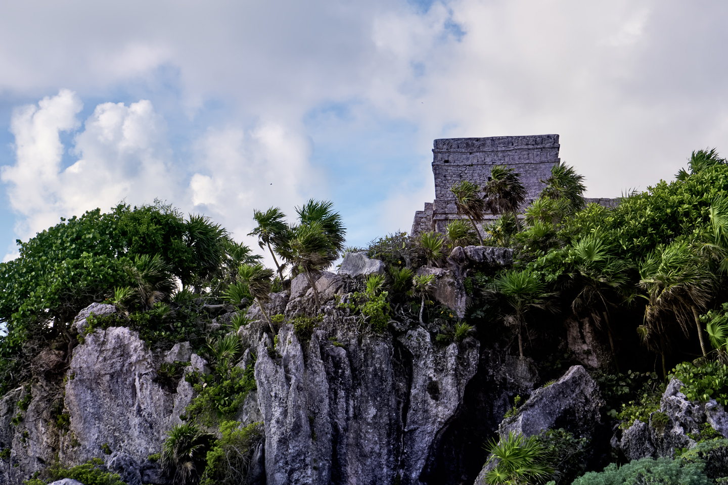
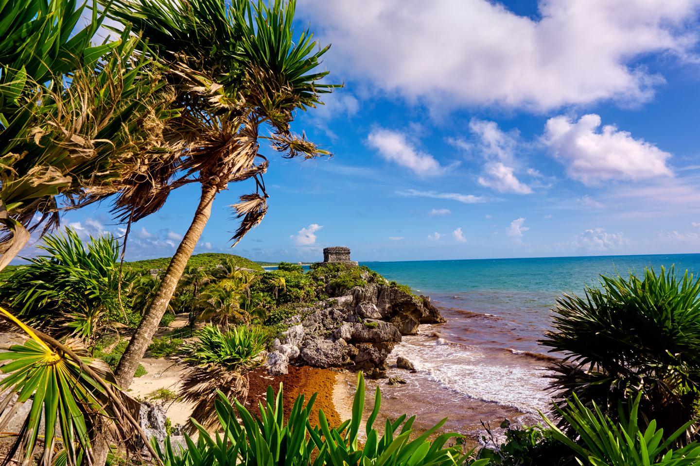
Tulum was never “rediscovered,” or stumbled upon, like so many other Mayan sites, because it was never lost. It’s one of the few Mayan cities that was still in use when Europeans first arrived in the area. After it was abandoned, the tropical vegetation enveloped the stone structures, but they never disappeared from view because the Castillo, the site’s largest building, is perched on a prominent bluff overlooking the coastline. It was put there to serve as a landmark, clearly visible from the sea, and so it is. Spanish Captain Juan de Grijalva’s expedition sailed past Tulum in 1518, and in his words, it was “a village so large that Seville would not have appeared larger or better.”

The American writer John Stephens and his illustrator, Frederick Catherwood visited Tulum on their second expedition to the Yucatan in 1841, which they documented in Stephen’s book, a two-volume set titled Incidents of Travel in Yucatan, first published in 1843. This set complemented his earlier work, Incidents of Travel in Central America, Chiapas, and Yucatan, which had been very well received in Europe, as well as in the United States. Catherwood’s meticulous illustrations of the ruined cities, the stelae, and the mysterious glyphs were the revelation that brought the ancient Maya to the attention of the outside world. The buildings in those drawings were clearly the product of an advanced civilization, previously unknown, yet possessed of artistic sensibilities and architectural expertise on a level with that of the ancient Greeks. The implications were staggering, and the source of much spirited debate among the intelligentsia of the mid-19th century.

Famed archaeologist and Maya expert Sylvanus Morley, the original real-life Indiana Jones, did preliminary excavations at Tulum beginning in 1913. Additional work was funded by the Carnegie Institution from 1916 until 1922, followed by a series of investigations in every decade through the 1970’s. When the developers who created Cancun opened for business in 1974, the surrounding area saw a flurry of growth that turned the archaeological site of Tulum into a bonafide tourist attraction. With the further development of the Riviera Maya, Tulum, the charming beach town adjacent to the ruins became a destination in its own right.

When you see a Mayan city in person, you can’t help but wonder what happened to the people who built it. The Mayan civilization was wondrously complex, and it flourished in this region for two thousand years. How is it possible for something like that to just disappear? Answer: it didn’t. At least, not all at once. The large inland cities were abandoned, largely by attrition, when an extended drought in the region caused crop failures that led to mass starvation. Tulum, and most of the smaller Mayan communities that were still occupied when the Spaniards arrived were exposed to the diseases brought from Europe; they had no natural resistance, so, once again, many of the people died. The survivors spread out through the area, eking out a meager existence as simple subsistance farmers, living in scattered hamlets and homesteads. Their numbers were greatly reduced, but the people were still there, speaking the same language, following the same essential traditions. What disappeared was all the high drama, the pomp and the grandeur, the art, the architecture, the priesthood and the pampered nobility. The people had no further need for any of that, and as for the old stone cities? They just walked away, and let the jungle swallow them up.

VISITING TULUM

Click for an expanded view of all maps and photos

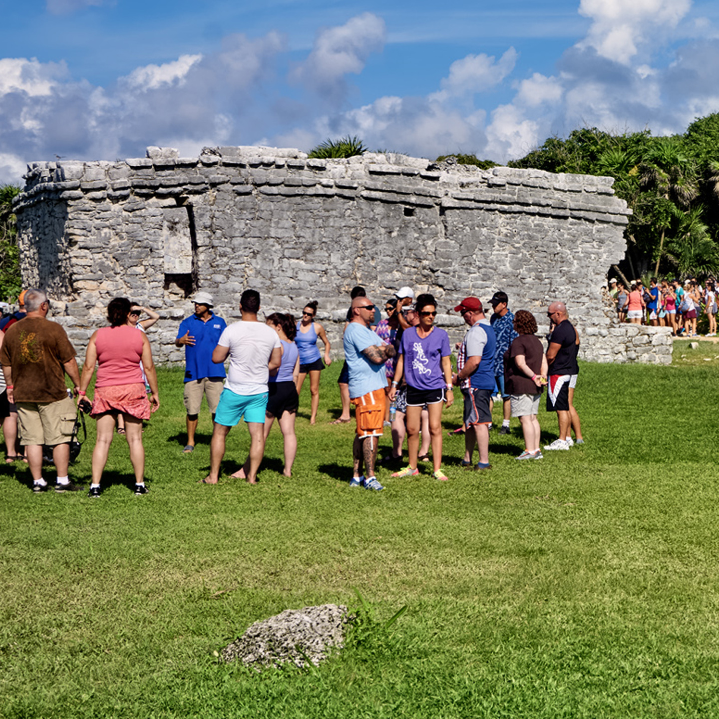
On my most recent trip to Mexico, the quest for Mayan ruins was my top priority. We’d been to Palenque, Uxmal, and Chichen Itza, and even though each of those places was completely different, I was beginning to get a feel for the way things work at Mexico’s archaeological parks. I knew Tulum would be busy, so I wanted to spread my visit across two days, to increase my chances for decent photos. I used the Mexican version of Expedia to book a room ahead of time in the town of Tulum, and we drove down from Cancun, a little less than two hours away on MX 307, a modern highway that parallels the beaches along the Riviera Maya.

We checked into our hotel, had some lunch, then headed to the ruins, which are adjacent to the town. It was mid afternoon, so the park was relatively crowded, despite the fact that we were there in mid-October, the tail end of the rainy season, and one of the least busy times of year in this part of Mexico.

A TIP FOR PHOTOGRAPHERS

If you’re passionate about photography, and if your schedule allows, I highly recommend that you follow my lead: plan to stay the night in Tulum, and spread your visit to the ruins across two days. On your first day, you should look at everything. Use a map to memorize the layout of the ruins, and you should be able to take some decent pictures, despite the crowds, by carefully choosing your angles and using a good zoom lens. The park closes at 5:00, still too early for sunset photos, but the late afternoon light isn’t half bad.

The second day, skip breakfast if you have to, because you’ll want to return to the park at 8:00 AM sharp, just as it opens for the day. Most of the tour groups don’t start arriving until 9:00 or so, which gives you an hour to take your pictures, free of the usual crowds. You’ve already familiarized yourself with the layout, so you’ll know exactly where to go for the best vantage points, and you’ll have terrific early morning light.

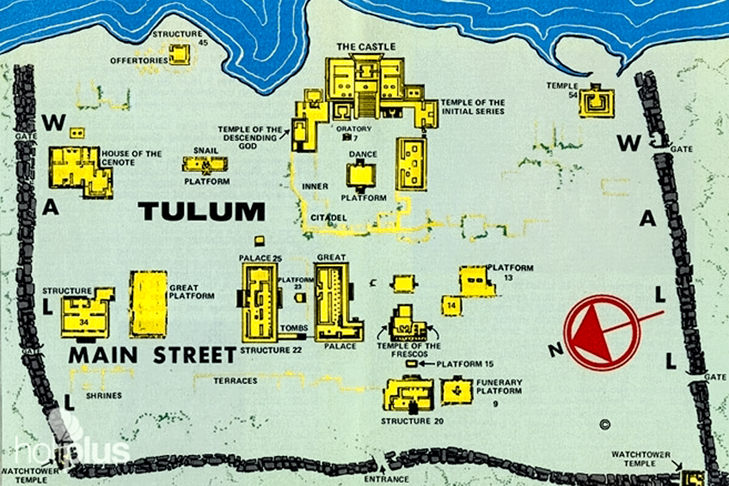
Map of Tulum and the surrounding area.

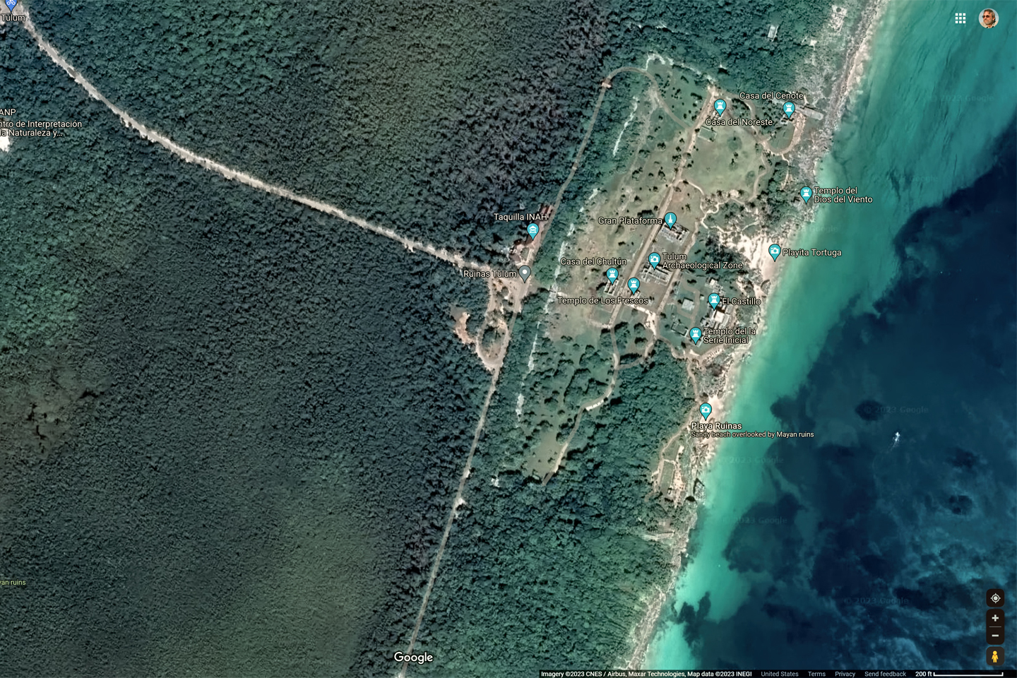
If you join a tour in Cancun or Playa del Carmen, they supply everything, from transportation to tour guide. The down side to that, they set the schedule, and they make all the decisions. If you’re like me, and that’s not your style, it’s simple enough to get to the ruins on your own. The best way is to rent a car, but there are also buses, colectivo taxis (cabs that take multiple passengers for a set fee per person), as well as private taxis, any of which will take you to the town of Tulum from anywhere along the Riviera Maya. The ruins are just 2.5 miles from the town center; close enough to walk, but there are shuttle services available throughout the day.

EXPLORING THE RUINS

Entrance to the Archaeological Park is just 85 Pesos per person, about $4.50 US. If you’ve driven yourself to the site, there is on-site parking that costs an additional 160 Pesos (about $8.00). It’s a half mile hike from the ticket booth to the ruins; if you’d like to save the exertion, a seat on one of the tractor-drawn carts that haul visitors back and forth will set you back another $5 or so.  Be sure to bring your own water. There are no concessions, and the only services inside the park are the restrooms.

If you’re not already attached to a tour group, it’s possible to hire a guide at the entrance, either privately, or in the company of a few other visitors. The site is small enough that you won’t really need assistance finding your way around; the benefit of the guide is in their patter, their well-practiced spiel about the history of the ruins, with details about the various buildings, local legends, and the occasional risque anecdote tossed in to spice things up.  You’ll have to decide for yourself, whether a guide adds enough value to warrant their fee.

A Mayan arch creates a passageway through the wall that surrounds the ancient city, one of five entry points 
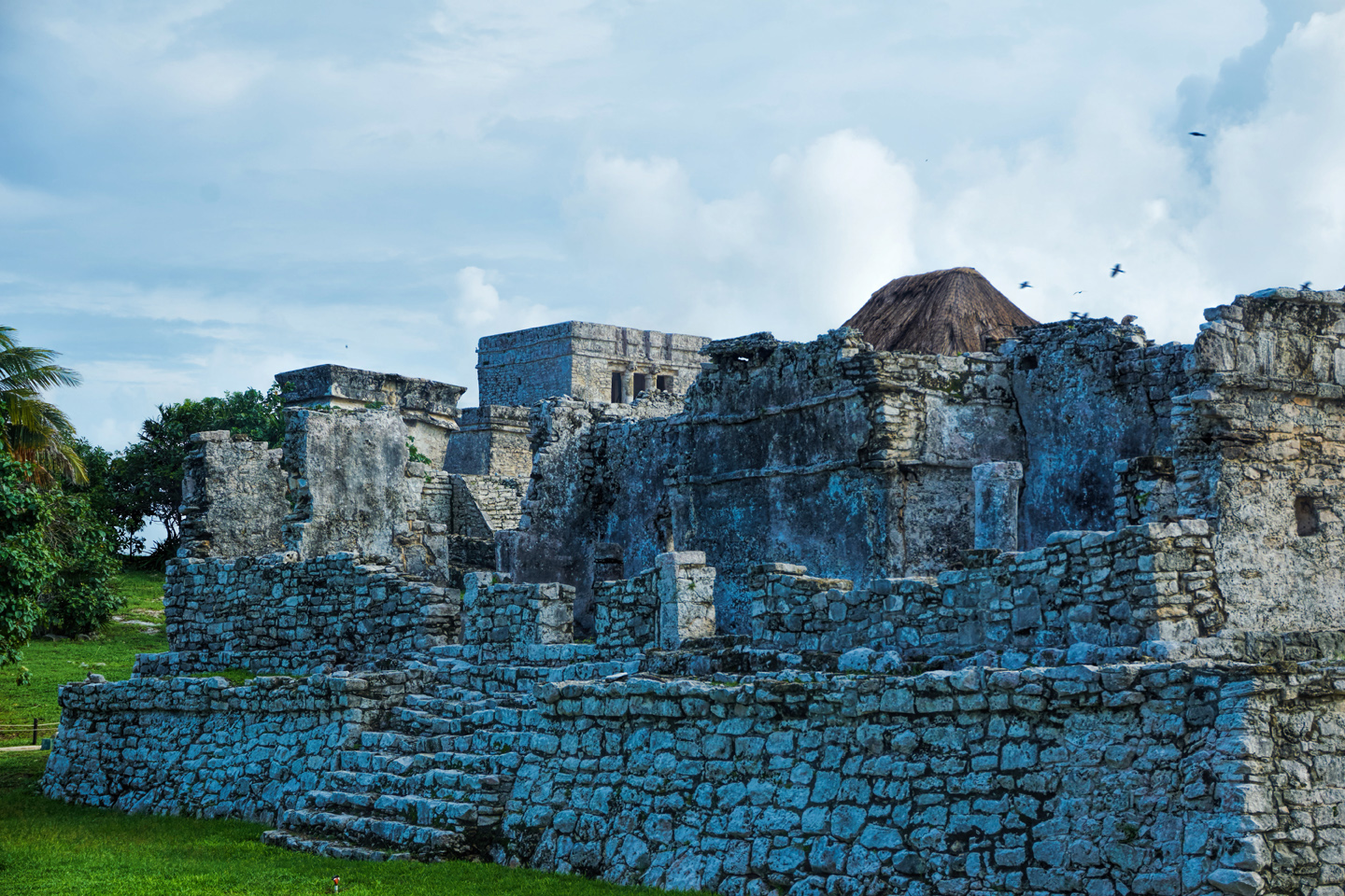
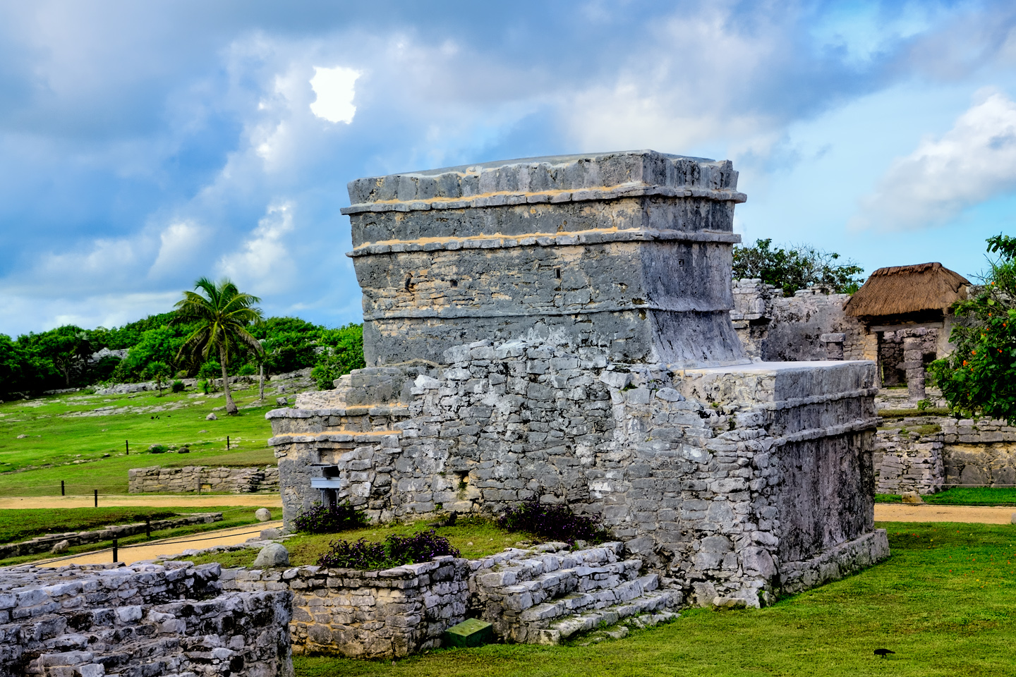
THE CASTILLO

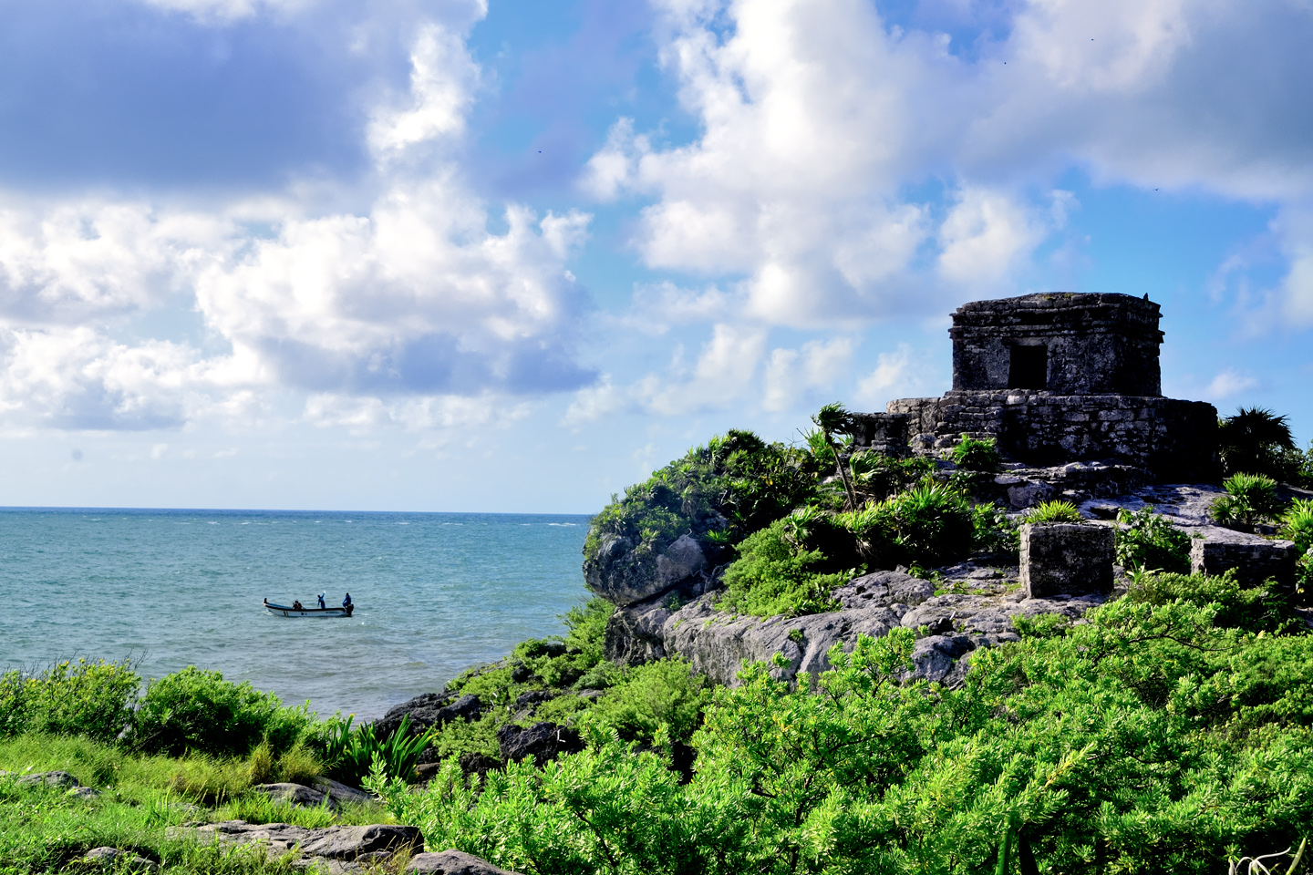
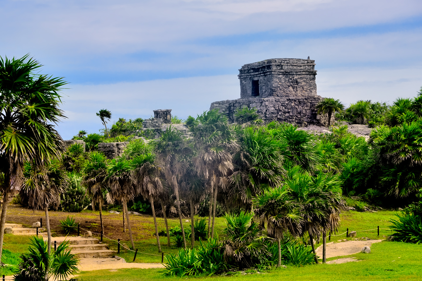
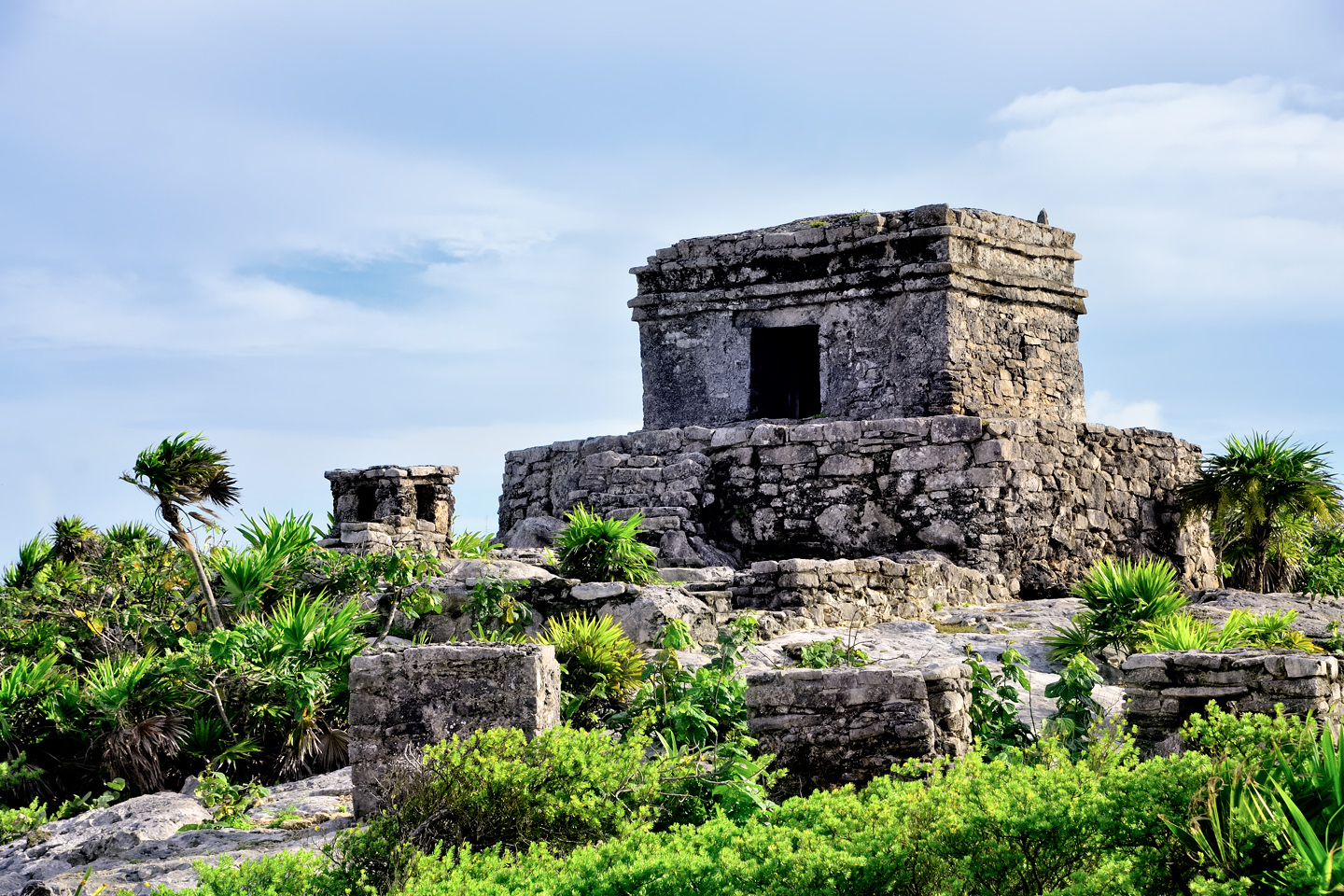
The structure best known as the Castillo, the Castle, is a squat truncated pyramid, with a squarish temple on the top and a broad, rather steep staircase climbing the front side. At 25 feet in height, it’s the tallest building in Tulum, the first thing you see when you enter the complex of ruins; an impressive bit of Peten style architecture that dominates the scene.

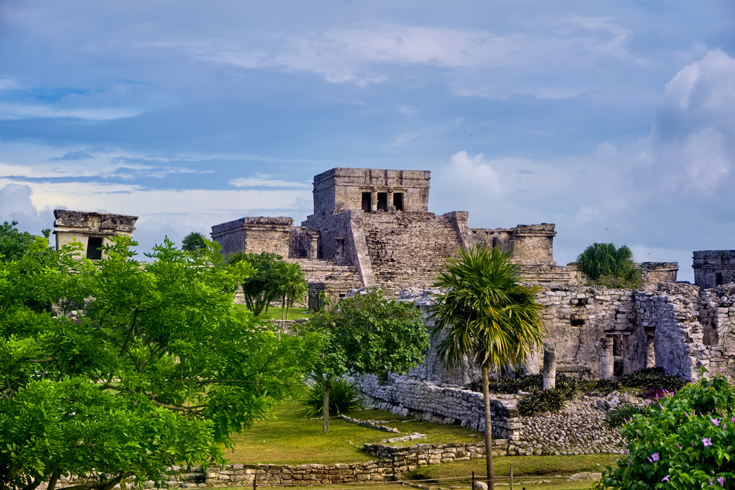
The Castillo was never used as a residence, so calling it a “Castle” is a bit misleading. The building is thought to have had several functions, and one of the most important was to serve as a landmark, and a lighthouse, readily visible from the sea, as a guide for the trading canoes that plied the coastal waters. It started as a simple shrine at the top of a cliff, but like most Mayan pyramids, new construction enveloped the original building in successive layers, until it evolved into the remarkable monument that you see today.

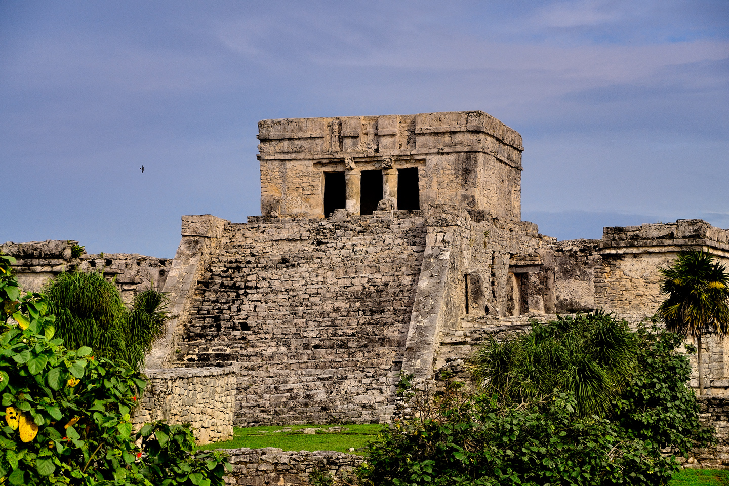
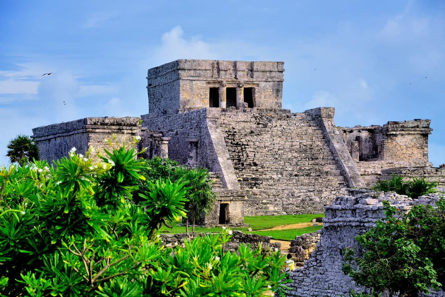
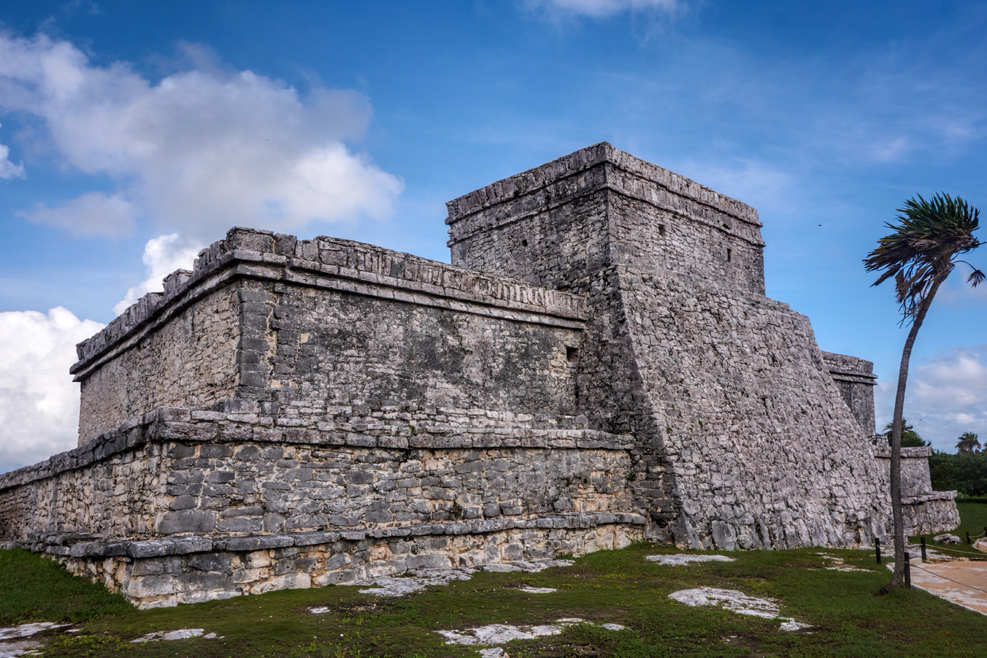
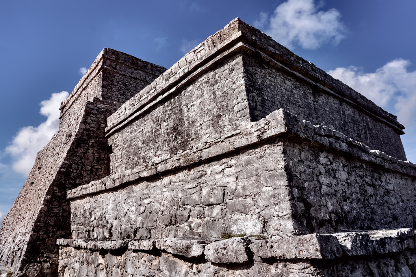
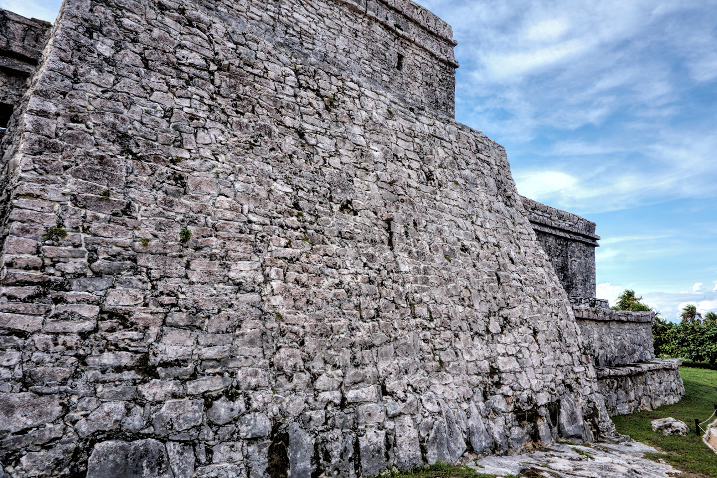
The Castillo is a Late Post Classic pyramid that’s reminiscent of the buildings at Mayapan and Chichen Itzá, with a very definite Toltec influence. When in use, this combination temple, shrine and lighthouse would have been coated smooth with stucco, painted, and adorned with molded masks and other artwork. The world’s second longest coral reef runs parallel to the east coast of the Yucatan, just under the surface of the sea. It has presented a hazard to shipping since the days of the Maya, but there’s a natural break in the reef, just offshore from the cliffs of Tulum. The sea-facing wall that buttresses the back side of the Castillo was painted bright red, and served as a beacon, guiding boats through the break to the staging area for the port, on the beach below the cliff. The windows in the back wall of the crowning temple would have glowed like a pair of eyes from the signal fires within, for the benefit of boats arriving after dark.

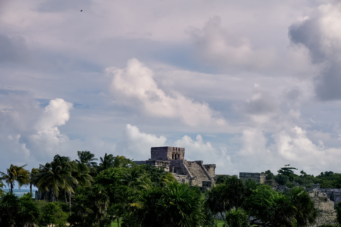
Tulum is the only Mayan city of any size located on a Caribbean beach, which further emphasizes its importance as a port and trading center. Canoes laden with luxury goods came around the Yucatan peninsula from trading centers along the Gulf of Mexico, while others followed the coastline north from as far away as Honduras, possibly even farther. The bright red Castillo, perched atop its cliff, would have been a welcome sight for the weary paddlers in their heavy canoes, a chance to unload and claim their reward, and to rest, before moving on again.

TEMPLE OF THE WIND

After the Castillo, the next most famous structure at Tulum is a relatively small building known as the Temple of the Wind. It’s not the least bit impressive from an architectural standpoint: a square shrine, with a cement roof and a single door, built atop small stone platform . What makes this one special is location, location, and location! Perched on a rocky outcropping that juts out into the sea, this is another structure that’s visible from the water for a considerable distance. Perfectly situated to catch the offshore breeze, it’s an ideal spot to put a shrine dedicated to the wind god.

Three views of the Temple of the Wind, a Mayan shrine on the azure shores of the Caribbean Sea

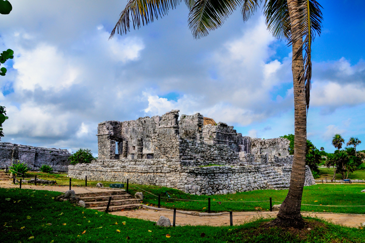
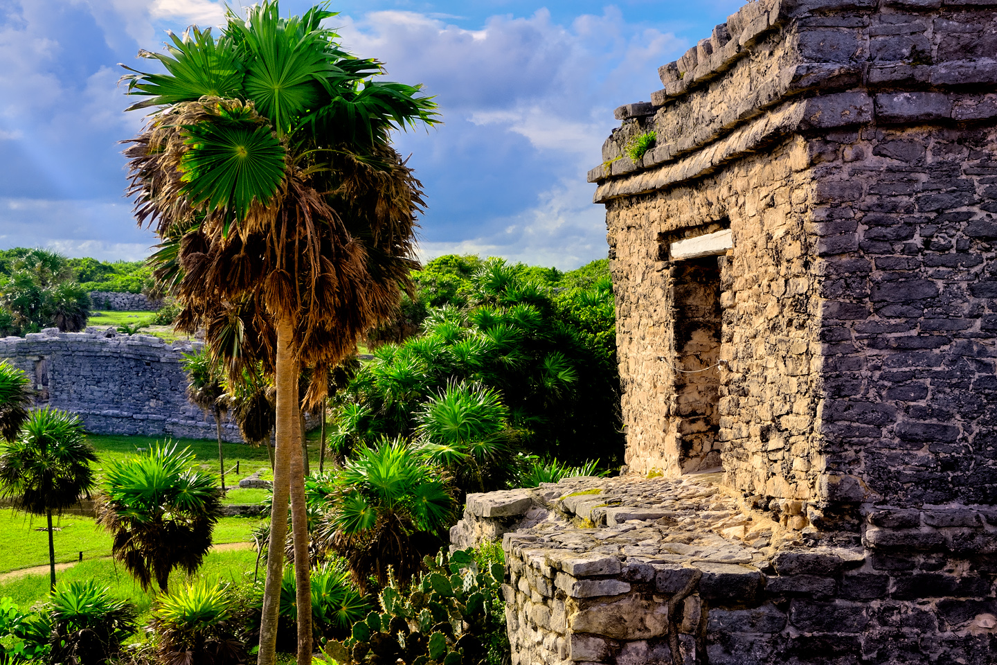
THE PALACE (HOUSE OF THE COLUMNS)

There are several large buildings in the plaza at the foot of the Castillo. The Palacio, the Palace, sometimes referred to as the House of the Columns, was a four room structure that was used as a residence by the city’s elite. Numerous columns supported the beam and mortar roof, which long since deteriorated to the point of collapse. Some of the original stucco with traces of red pigment can still be seen on the wall at the rear of the building.

Your content goes here. Edit or remove this text inline or in the module Content settings. You can also style every aspect of this content in the module Design settings and even apply custom CSS to this text in the module Advanced settings.

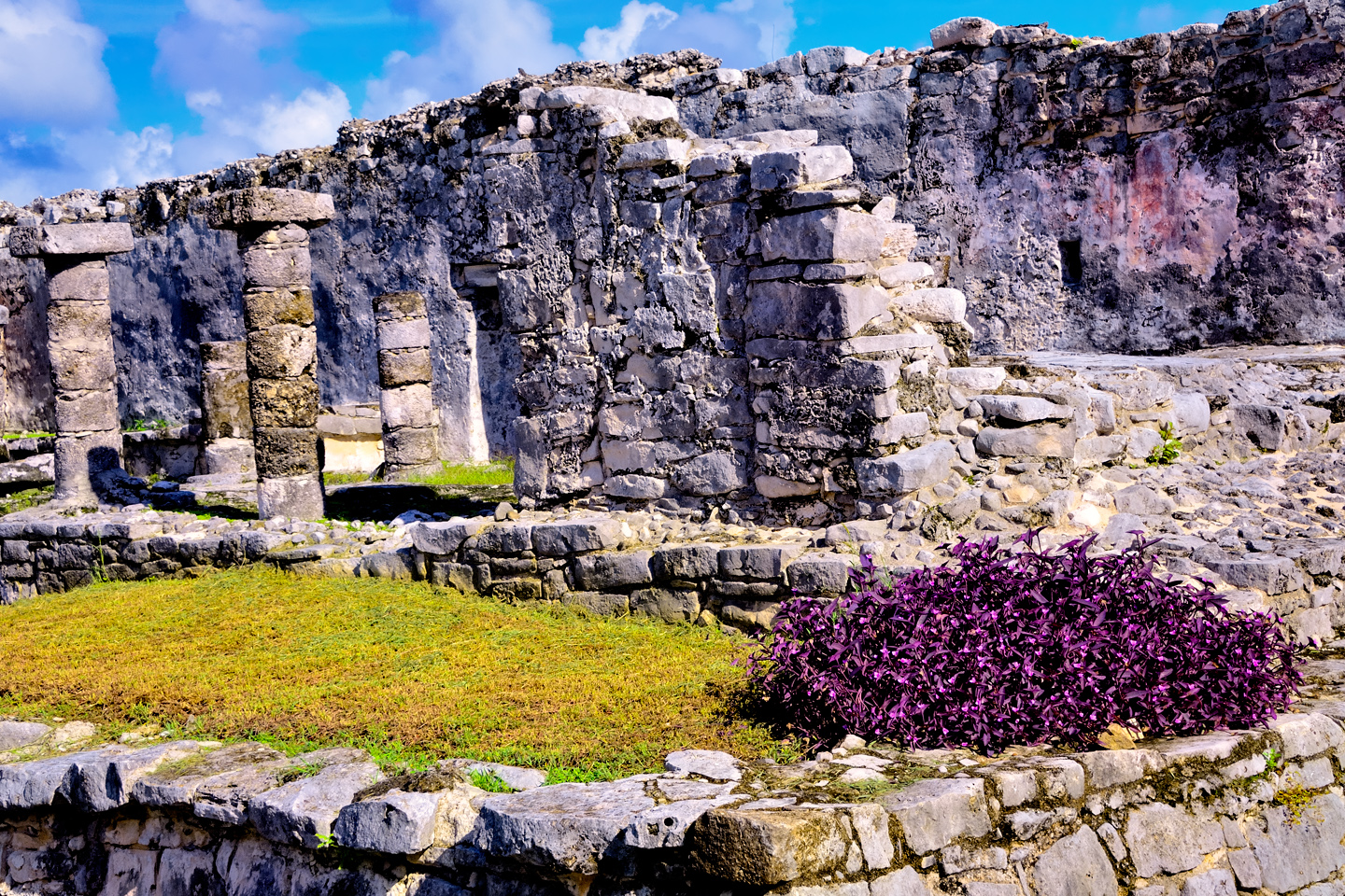
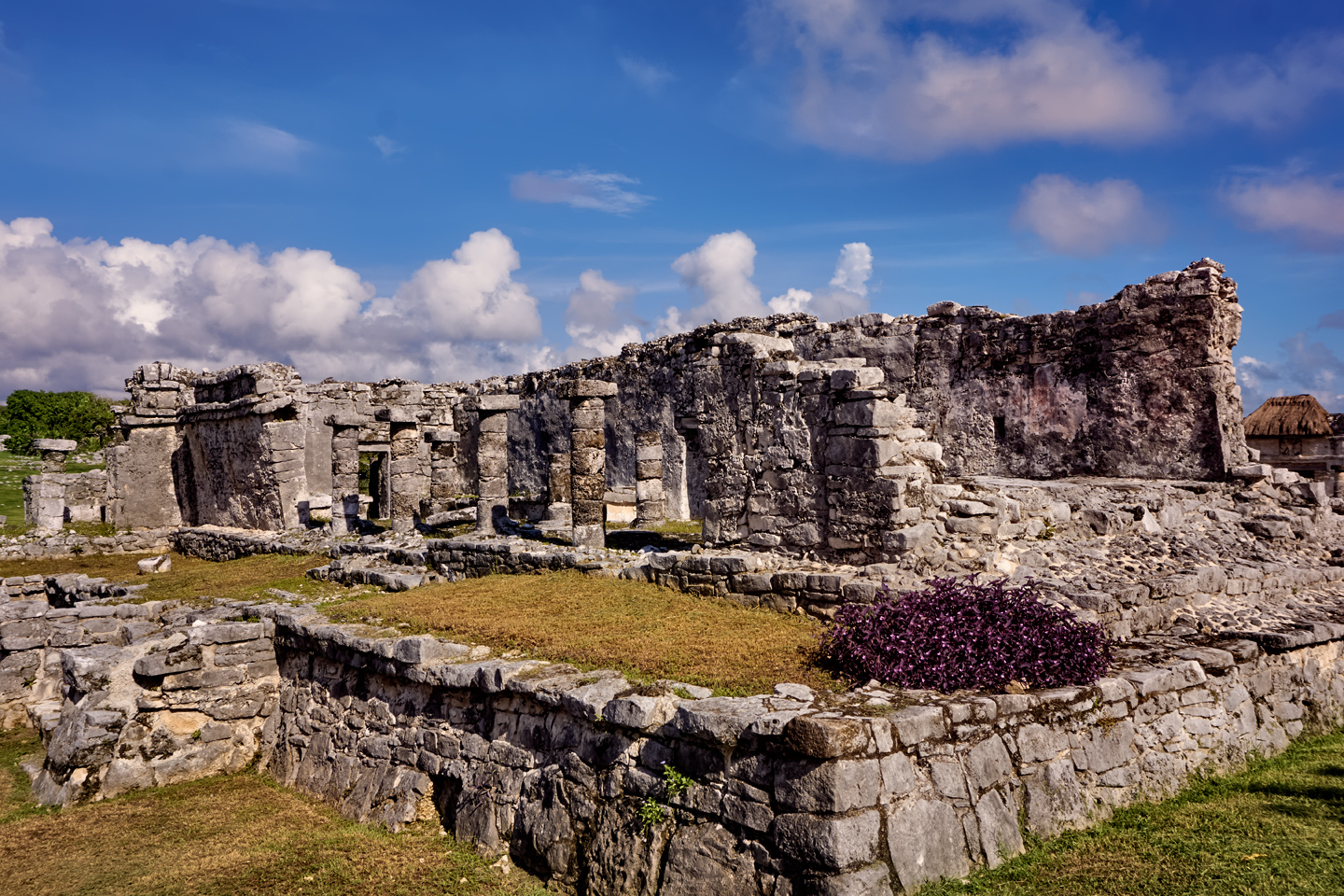
The Palace, also known as the House of the Columns
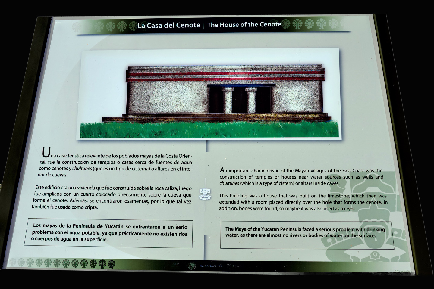
HOUSE OF THE CENOTE

Cenotes are natural sinkholes in the limestone bedrock of the Yucatan, and they’re an important source of fresh water in a region without lakes or streams above ground. This building was probably a temple of some sort, and at least one burial was located inside it. A new section was added to the original structure, directly above the roof of a water-filled cave. A hole dug through the floor provides access to the water. It’s not a natural cenote, but it clearly served the same purpose.
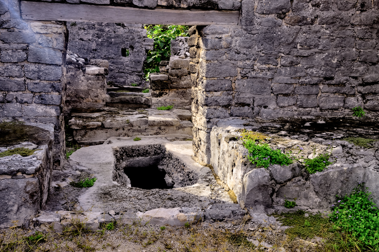
House of the Cenote

Temple of the Frescoes. Traces of red paint are still visible on the outside walls of the upper story. Note the cell phone tower in the upper left corner of the wide shot. That’s Progress: now you can post to Instagram instantly.

TEMPLE OF THE FRESCOES

Another impressive structure is the two story building known as the Temple of the Frescoes, named for the painted murals that once covered the interior walls. The murals have deteriorated significantly over the years, so visitors are no longer allowed inside the structure to view them. The moisture in our breath, especially when concentrated in a confined space, causes irreversible damage to these rare and precious paintings. Brightly colored murals once graced nearly every interior wall in the Mayan cities, but few have survived the ravages of time. 

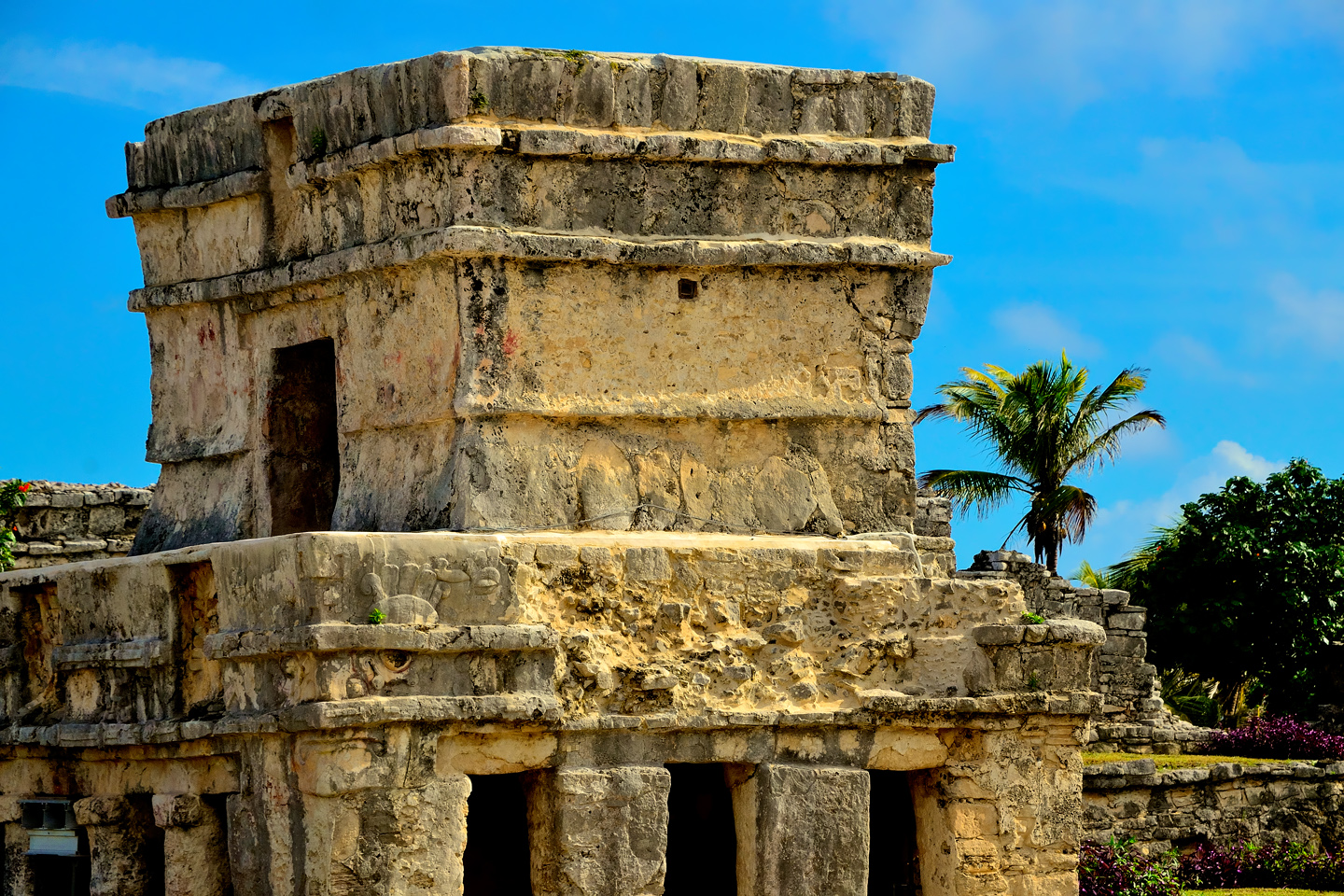
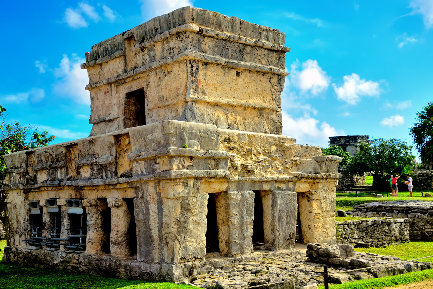
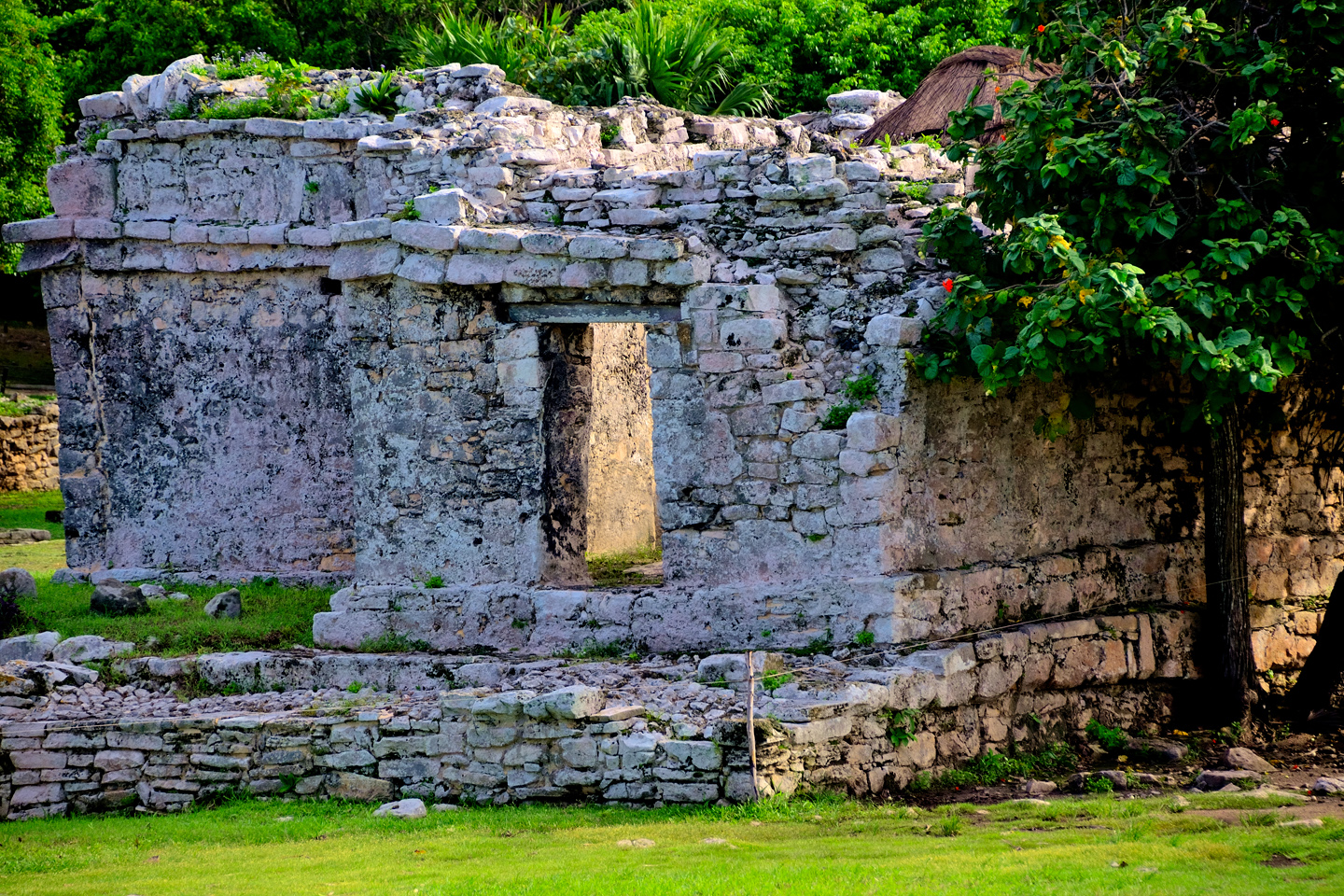
THE HOUSE OF THE HALACH UINIC

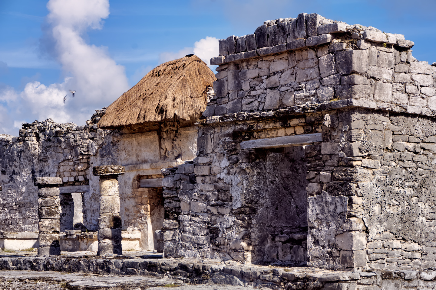
The ruler of Tulum was known as the Halach Uinic, a hereditary position passed on to the eldest son of the family. The ruler appointed all the administrators, and with their support he had absolute power over the community. The position came with an official residence, the House of the Halach Uinic, a massive structure that is still in remarkably good condition.

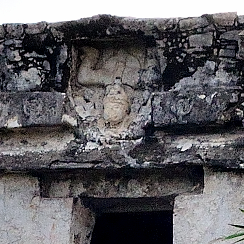
Above the doorway is a figure made from molded stucco, an image of the Descending, or Diving God, a winged deity that is always portrayed upside down, as if falling from the sky, with his arms pointed downward and his legs in the air. The Descending God had some special significance in Tulum, as it is a motif that is repeated on several of the important buildings.

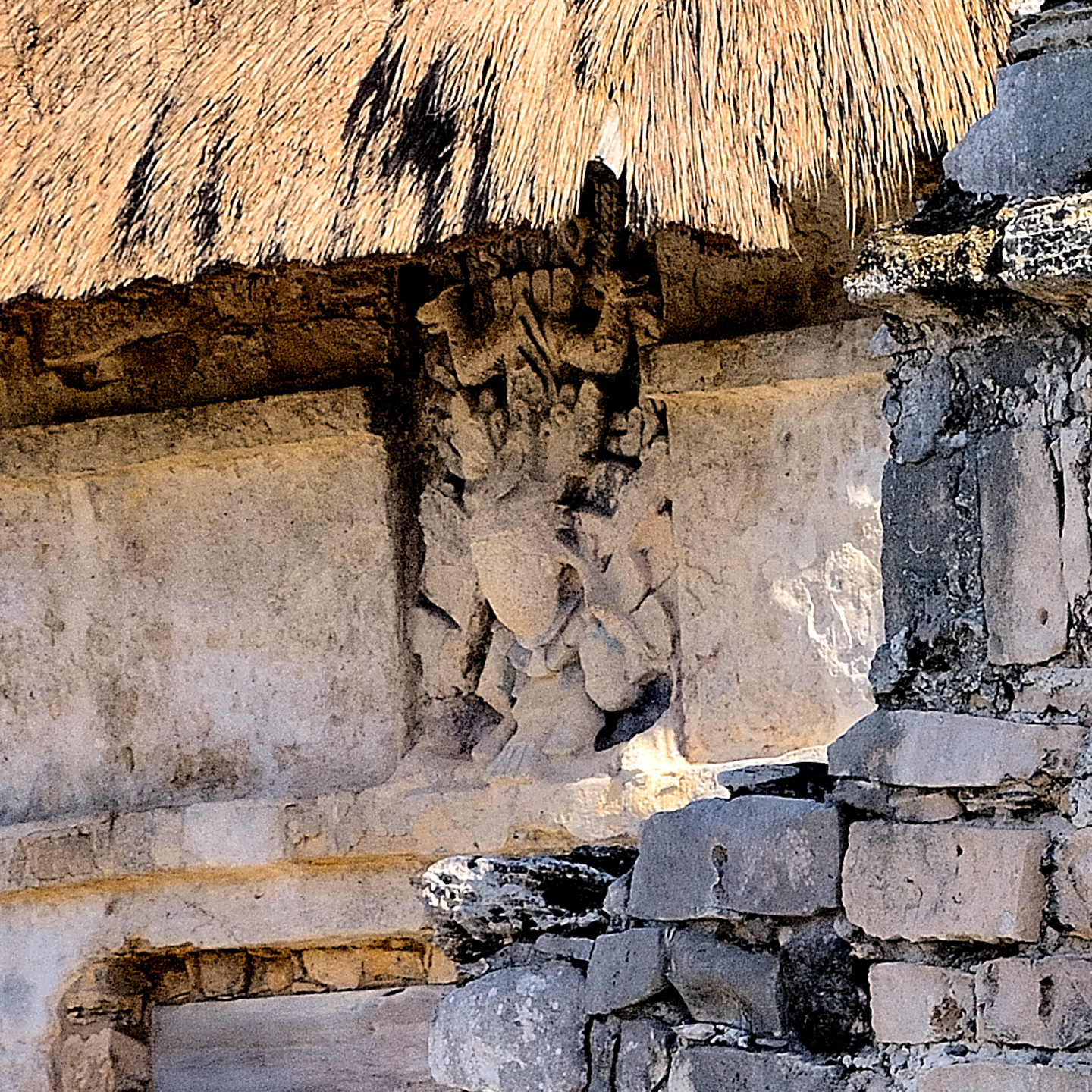
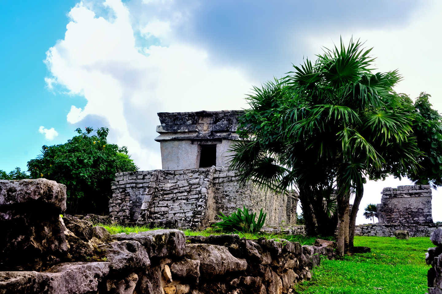
TEMPLE OF THE DESCENDING GOD

This small, rather elegant temple stands beside the Castillo, and is named for the molded figure of the Descending God that’s prominently featured in a niche above the door. There is a painted mural inside the building, but, just like at the Temple of the Frescoes, entry is prohibited, in order to protect the paintings from the moisture in visitor’s breath.

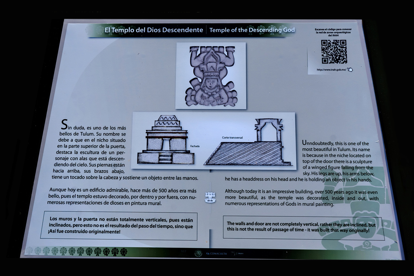
The Descending God is thought to be associated with the planet Venus, as well as with Ah Muu Zen Caab, the Mayan God of the Bees. Honey produced by bees was a mainstay of the trade that supported the noble houses of Tulum; it was used throughout the Yucatan as a sweetener, an antibiotic, and in a fermented drink called balché, similar to mead. Images of the odd god with his legs in the air are also found in the Mayan cities of Coba, Sayil, and Chichen Itzá, three of Tulum’s most important trading partners. The Mayan Cities were independent entities, but there were many connections between them that we’re only just beginning to understand.
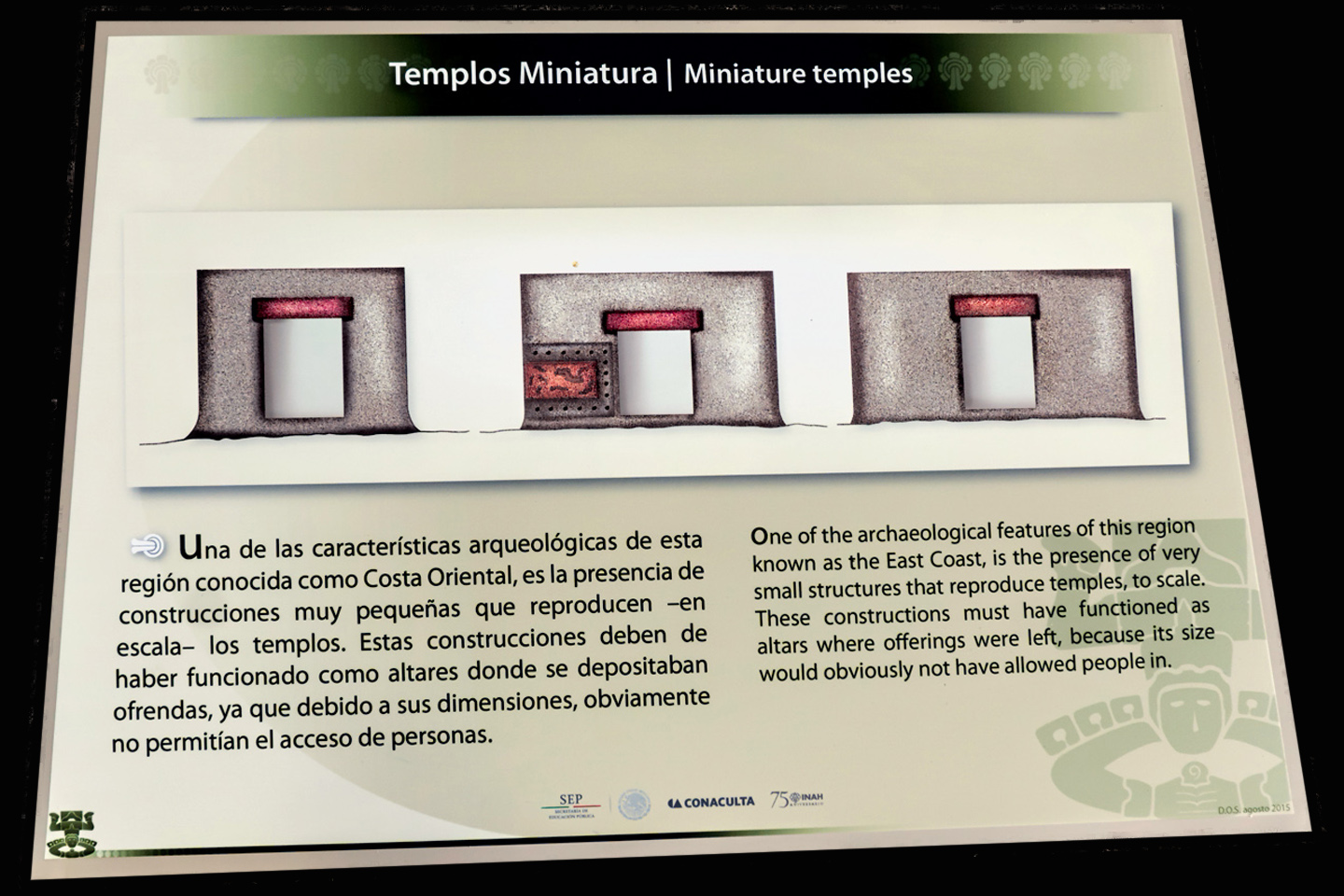
TINY TEMPLES

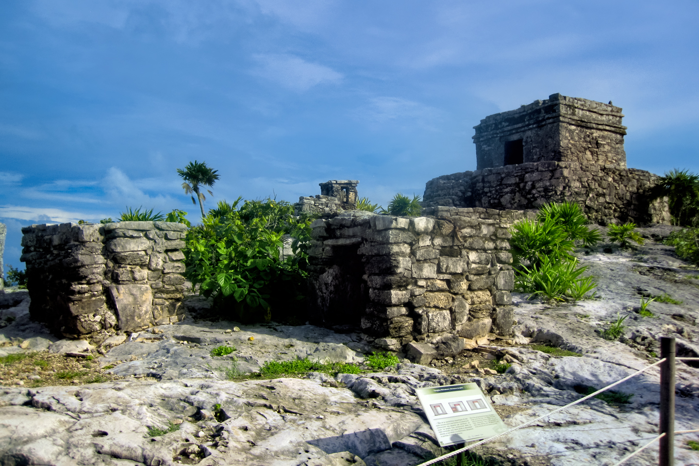
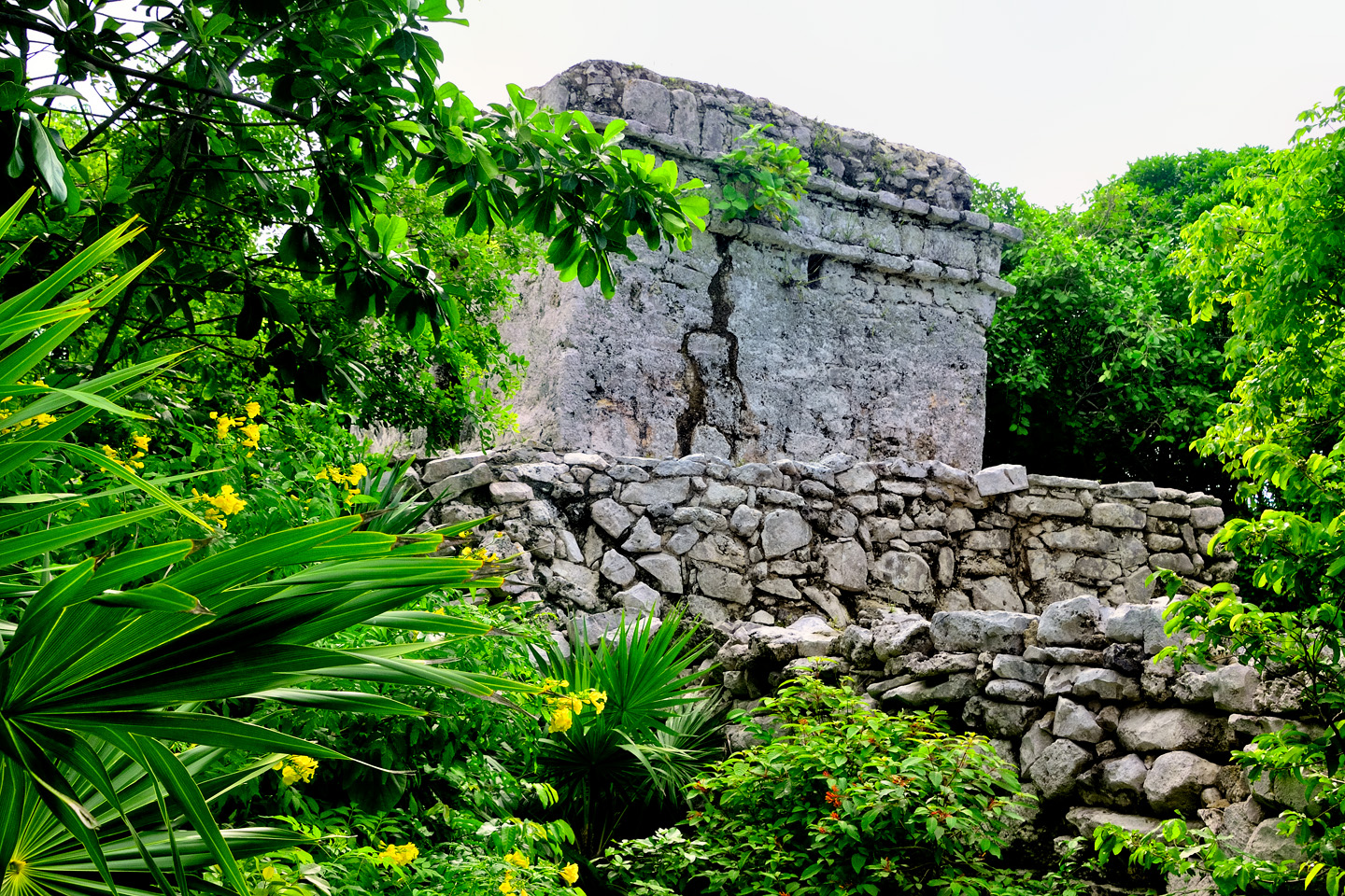
At several different locations, in Tulum, as well as in other Mayan communities along the east coast of the Yucatan, there are small structures that are like scale models of temples, complete with doorways and interior spaces. It’s assumed that these were used as repositories for offerings.
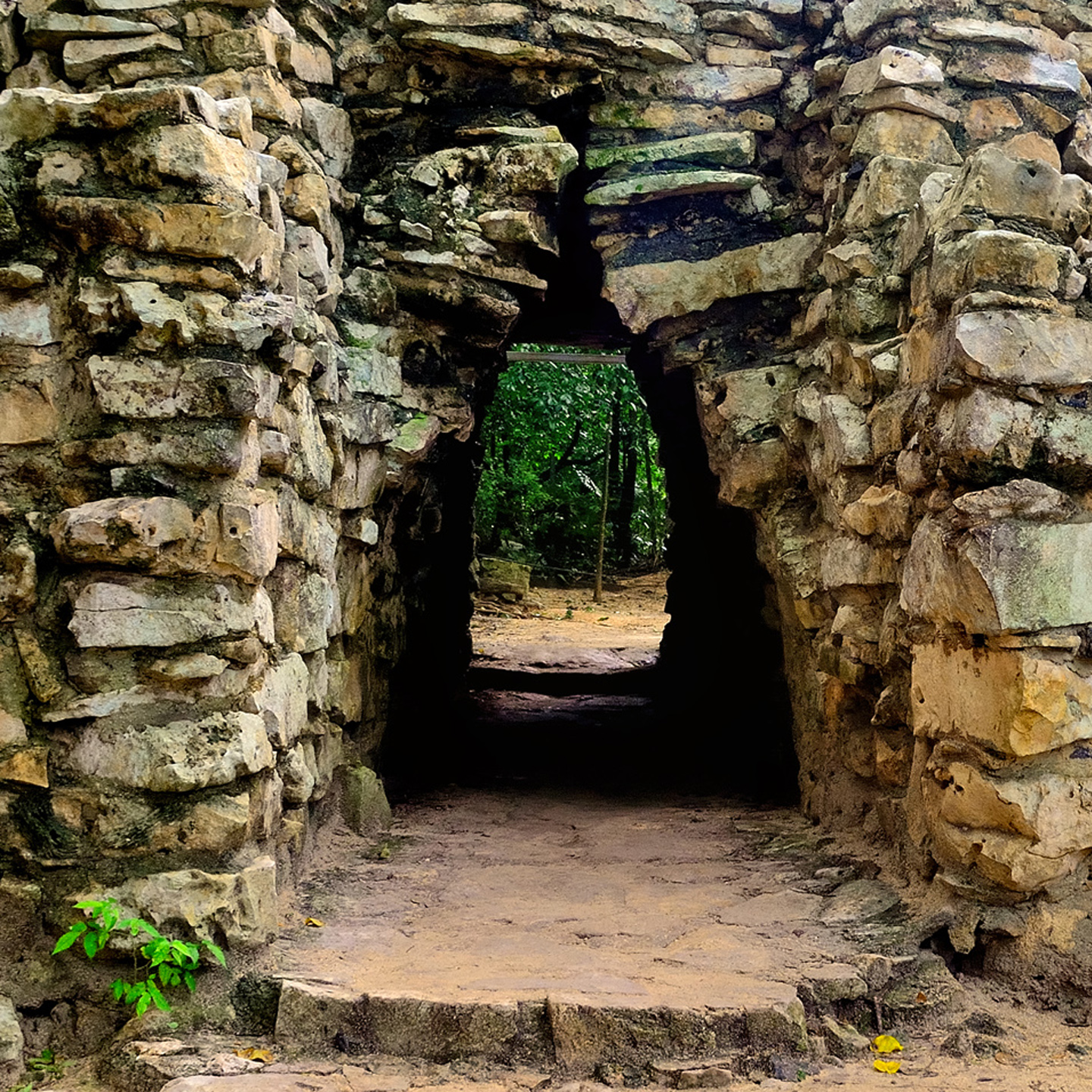
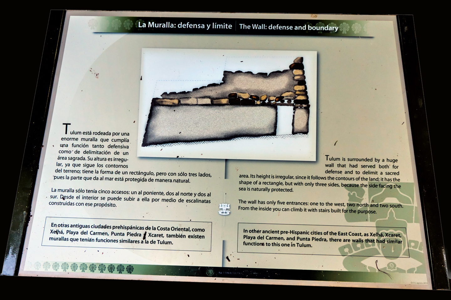
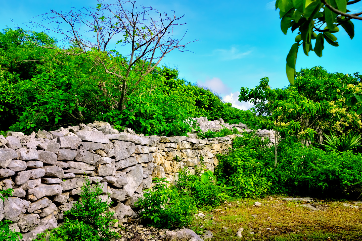
THE BOUNDARY WALL

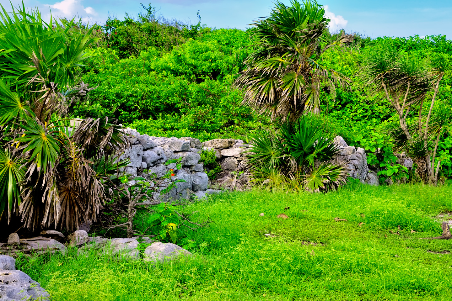
Tulum was protected by cliffs on the eastern, seaward side, and by a wall that surrounded the other three sides of the twenty acre ceremonial enclave. The wall is thought to have served a dual purpose. It was there to keep out invaders, and it was also a physical boundary between the elite priests and nobels and the common people. The massive barrier was a monumental construction in it’s own right. Built entirely of stone, it ranged from 10 to 16 feet in height, and it was as much as 26 feet thick, following the contours of the land for a total distance of 1300 feet, with the longest section, on the western side, running parallel to the sea. 

There are five openings in the wall, two on the north end, two on the south, and one in the center of the western side, which is currently used as an entrance for visitors. Some sections of the wall are hollow, with stairs on the inside leading up to the top. At each of the rear corners, there are structures believed to have been watch towers, vantage points for the guards that were needed to keep the city safe from attack by land, as well as by sea.

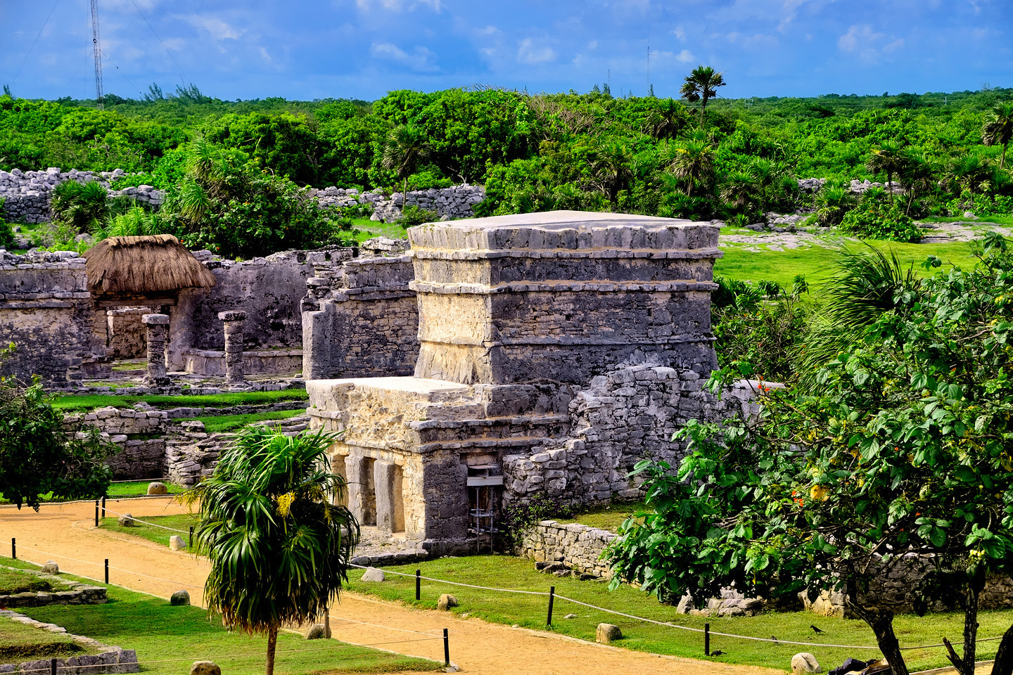
THE ELITE ENCLAVE, INSIDE THE WALL

Most of the residents of Tulum lived outside the wall in simple dwellings built of wood and thatch, materials that have not survived the passage of time. There are archaeological remains, plenty of stuff still buried for the scientists to sift through, but there’s nothing above ground for the rest of us to see, because the monumental construction was confined to the area inside the wall. 

The priests, the nobels, and the rising class of wealthy merchants lived a very good life here. Through their observations of the stars and planets, they knew the cycle of the seasons, when to plant and when to harvest, and with the wealth they acquired through trade, they had absolute control over everything that happened in their corner of the world. The common people were there to serve them, to see to their every need, and their trade relationships with the powerful lords of the inland cities kept them safe from other agressors. It was a true golden age, but it wasn’t destined to last.

SIGNS

The Mexican government’s Council for Culture and the Arts (Conaculta) has provided illustrated signage in both Spanish and English at various locations around the ruins. Some of them identify the buildings, while others provide interesting information about Mayan history and culture. Click the thumbnails to expand the images:

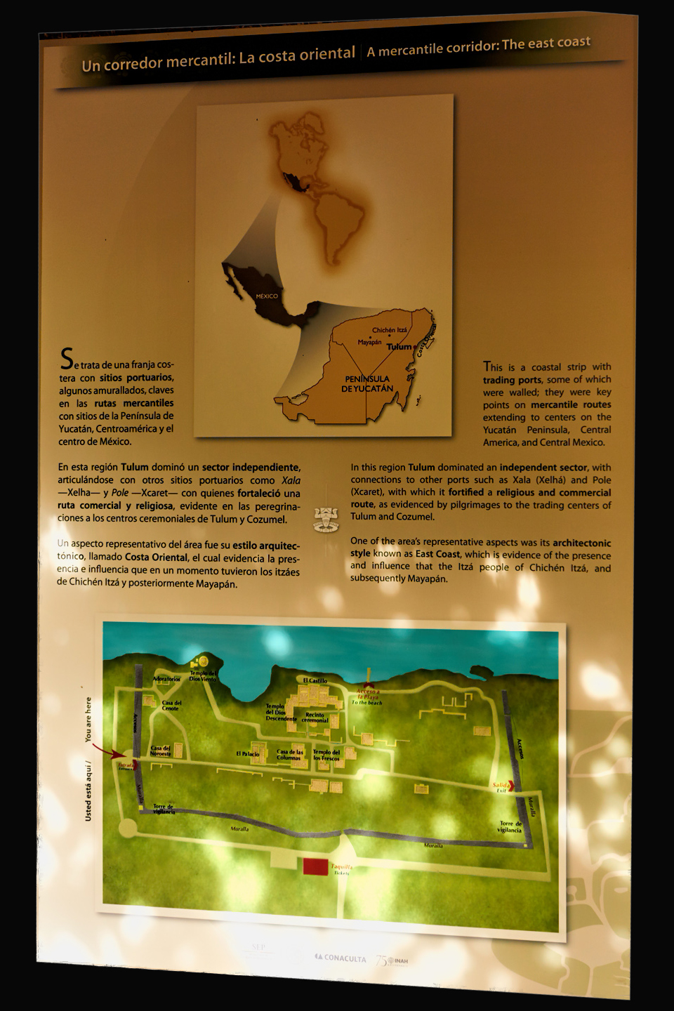
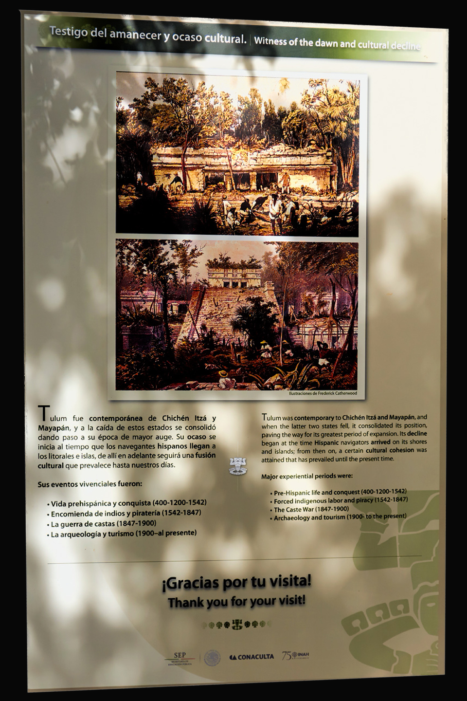
Witness of the Dawn: A Cultural Decline; and Mercantile Corridor: The East Coast

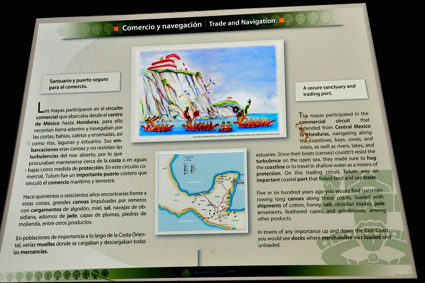
Trade and Navigation viewpoint
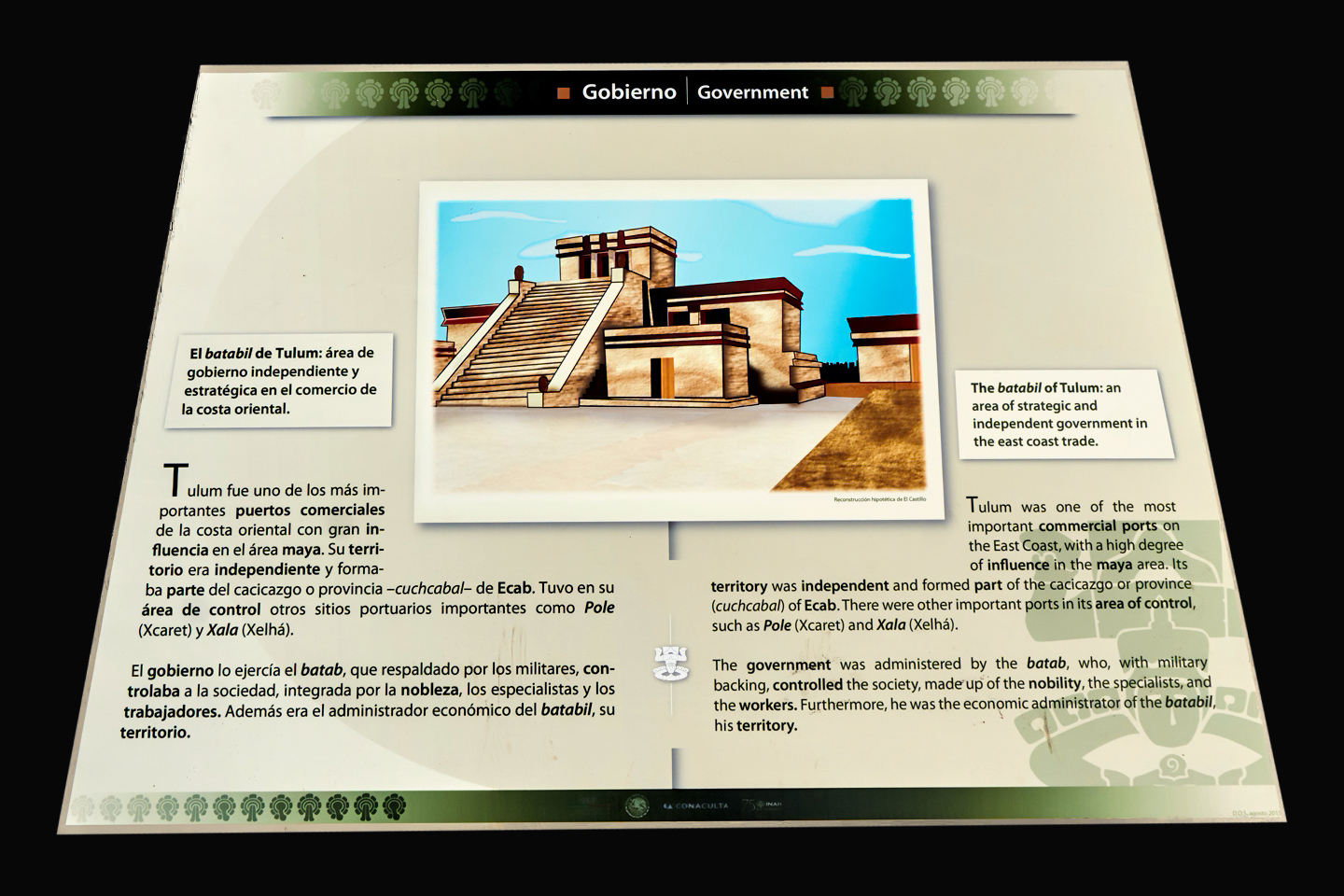
Government

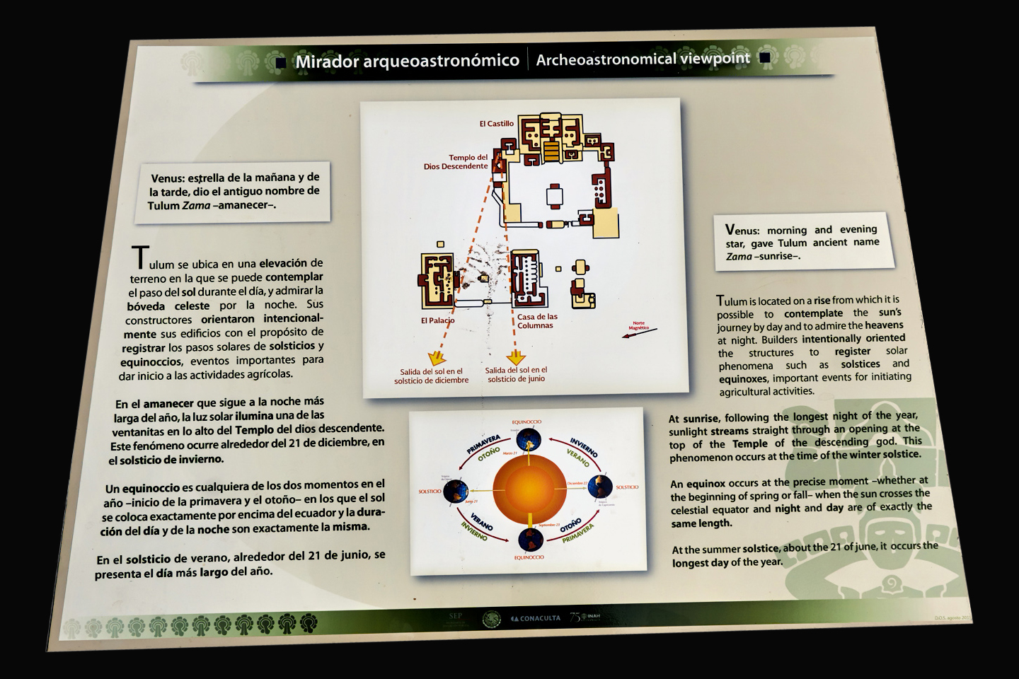
Archeoastronomical Viewpoint
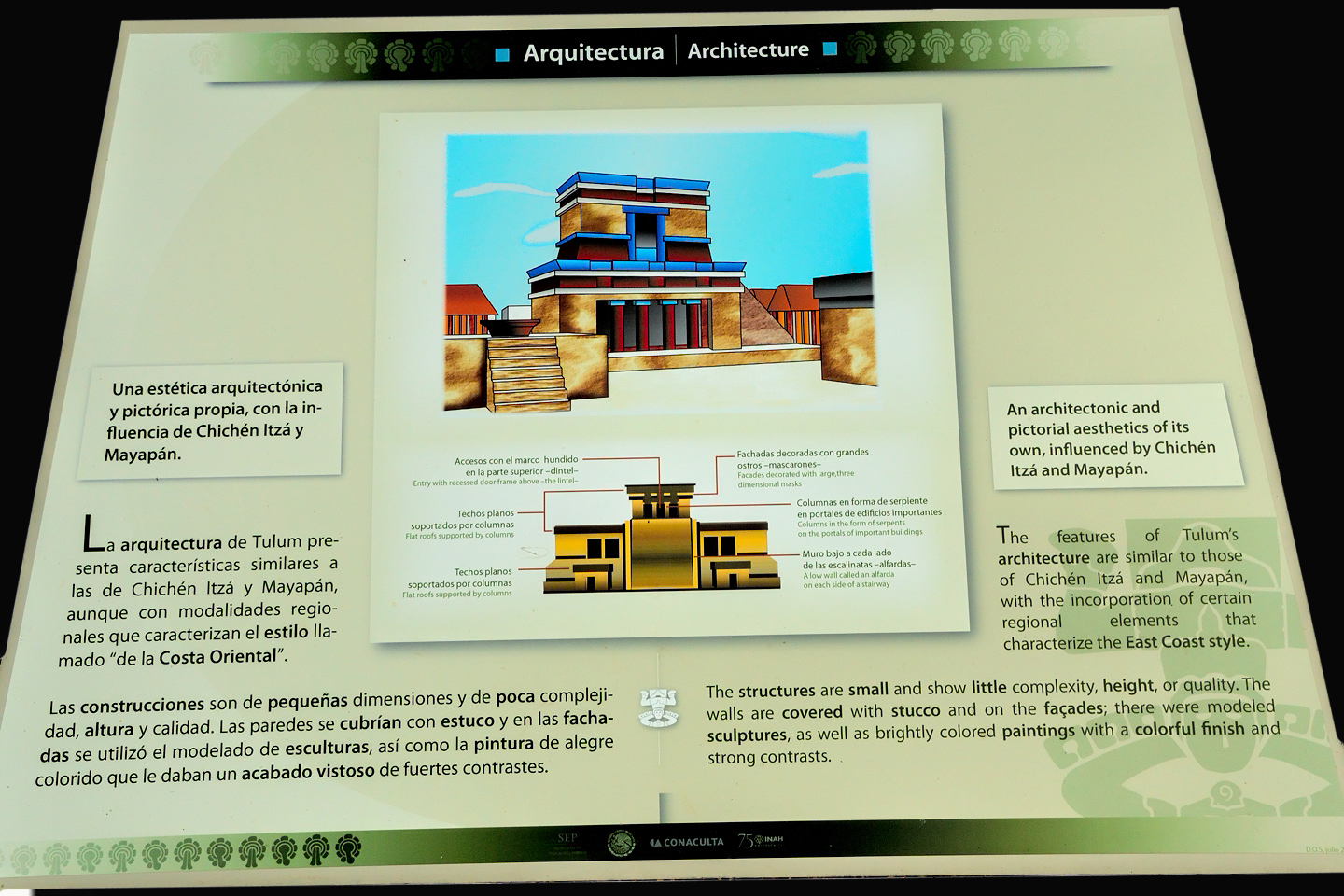
Architecture

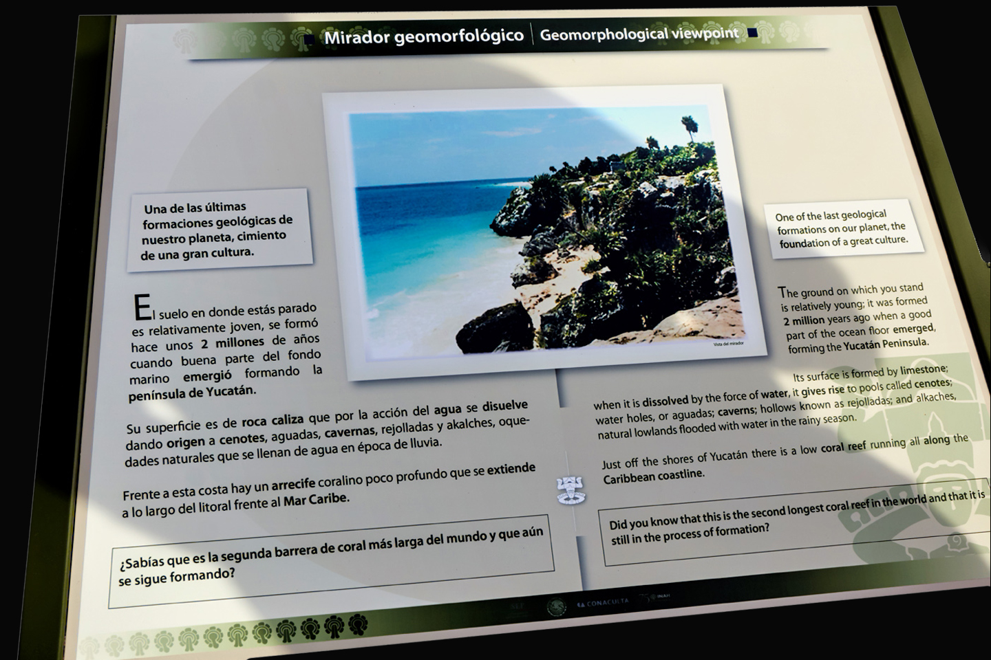
Geomorphological Viewpoint
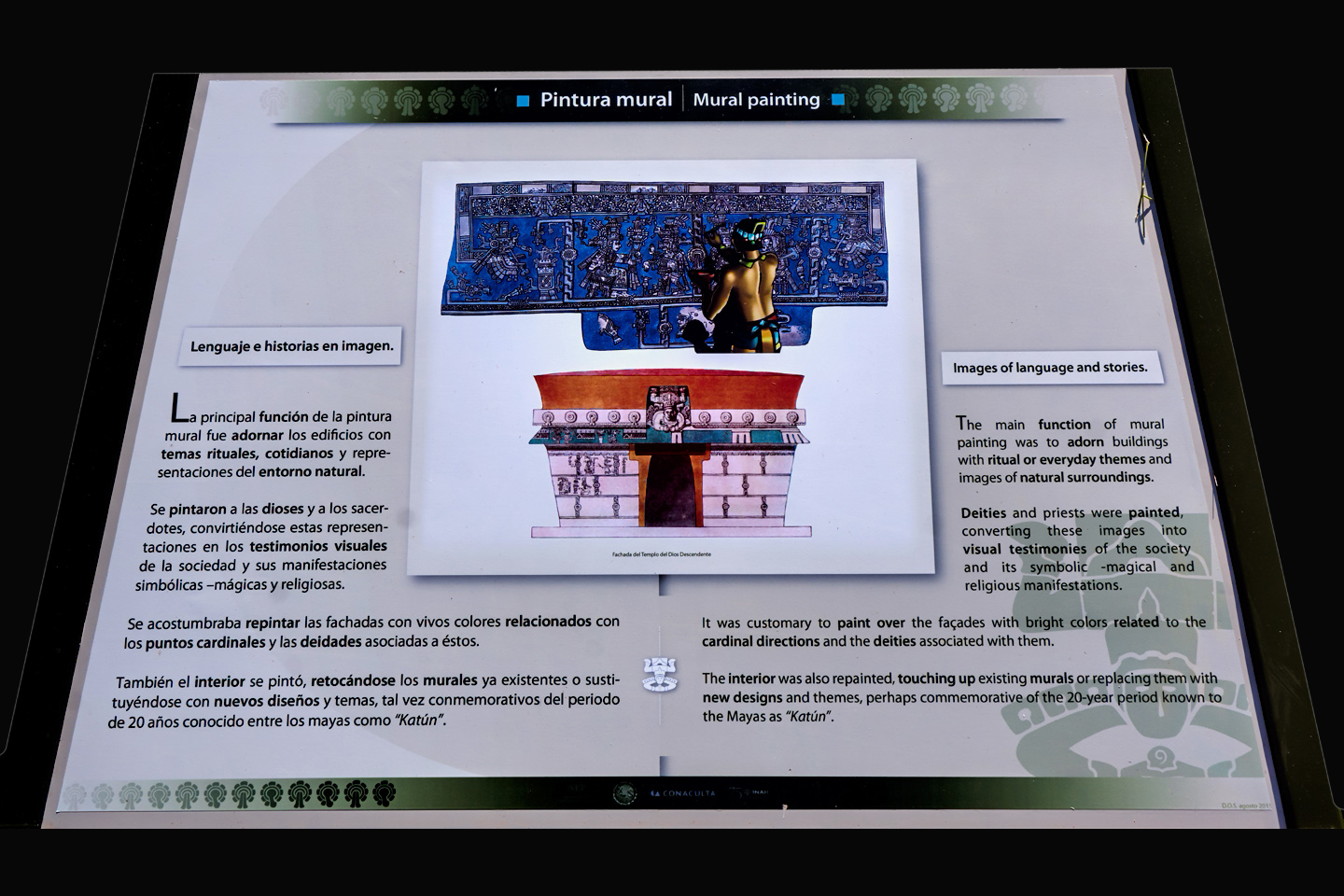
Mural Painting

CURRENT RESIDENTS

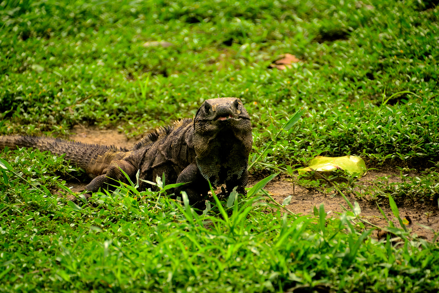
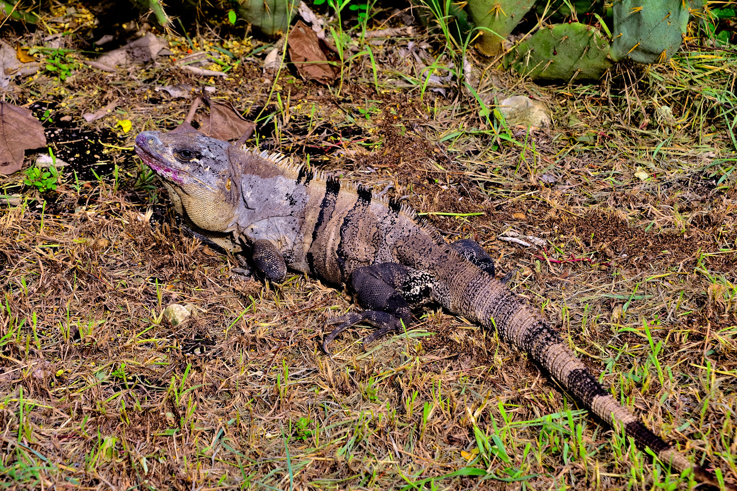
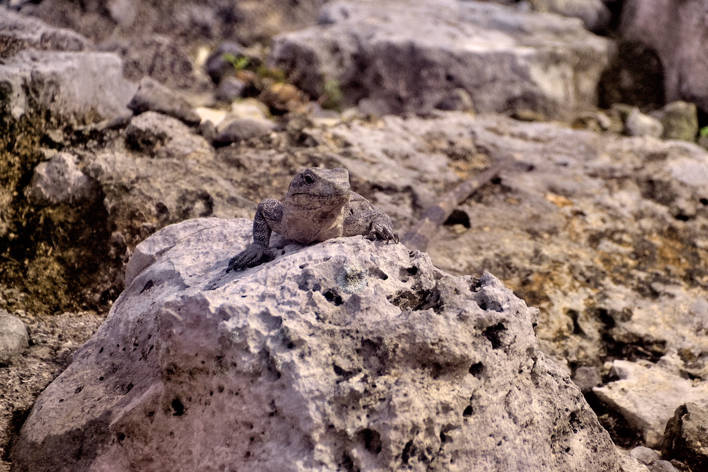
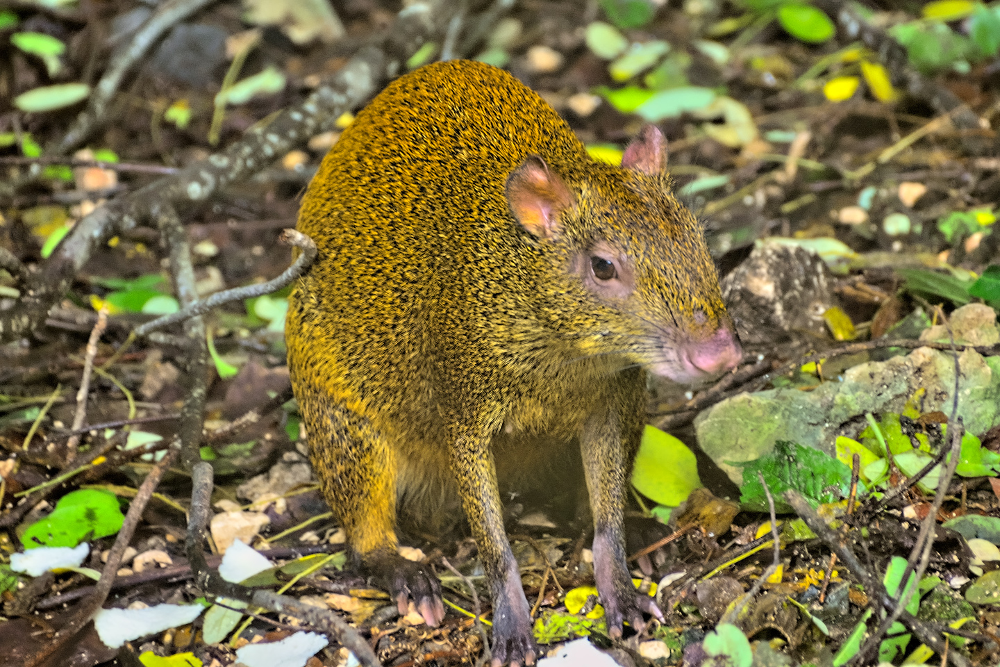
Assorted Spiny Tailed Iguanas among the ruins, and an Agouti in the Underbrush

Every Mayan ruin that we stopped at, from the  crowded sites like Chichen Itzá and Tulum to the less visited sites like Edzná, they all had one thing in common: they’re crawling with Iguanas! Mexican Spiny Tailed Iguanas, Black Spiny Tailed Iguanas, and Yucatan Spiny Tailed Iguanas, just to name a few. When the Mayans moved out, the Iguanas moved in, and they’ve made themselves very much at home among the ruins. 

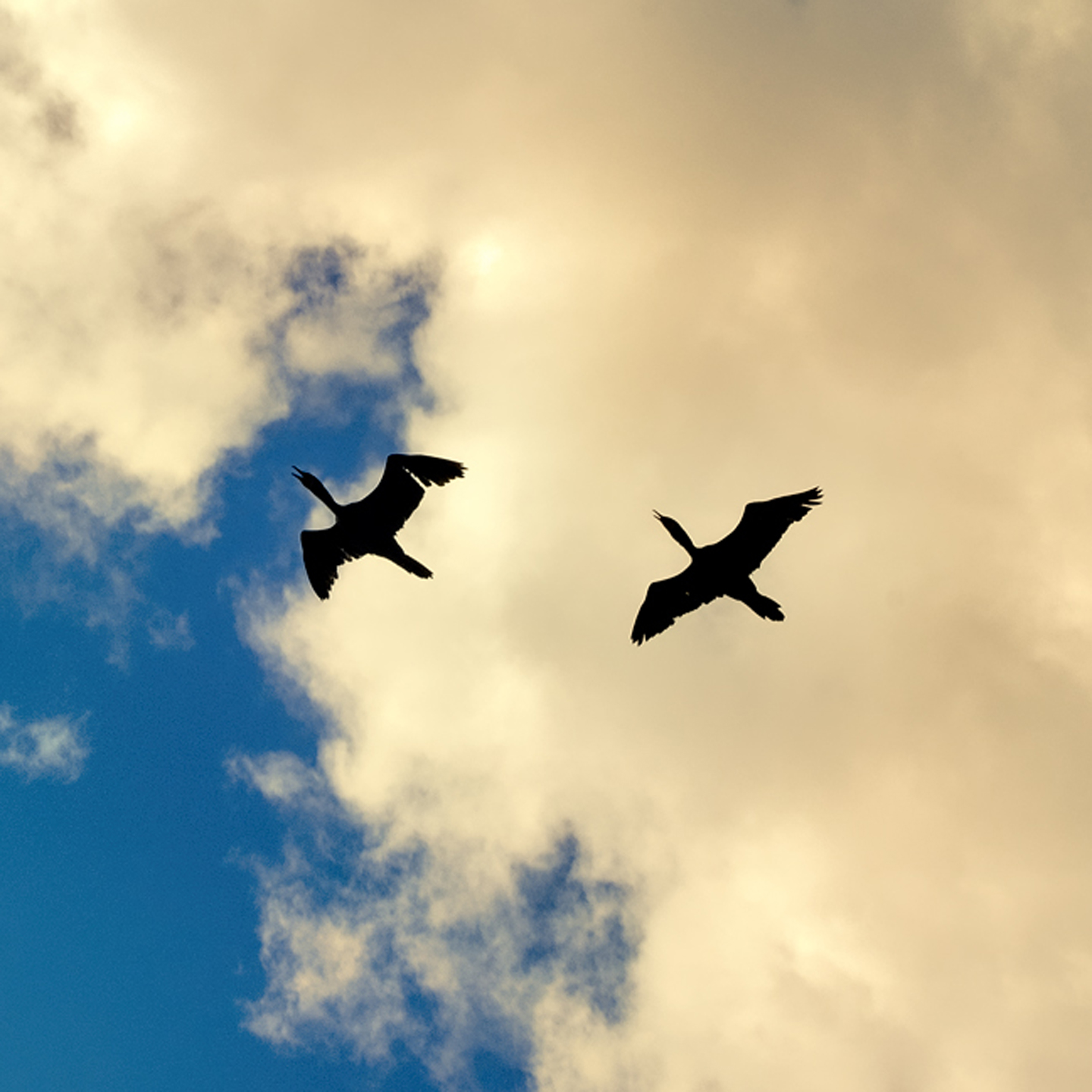
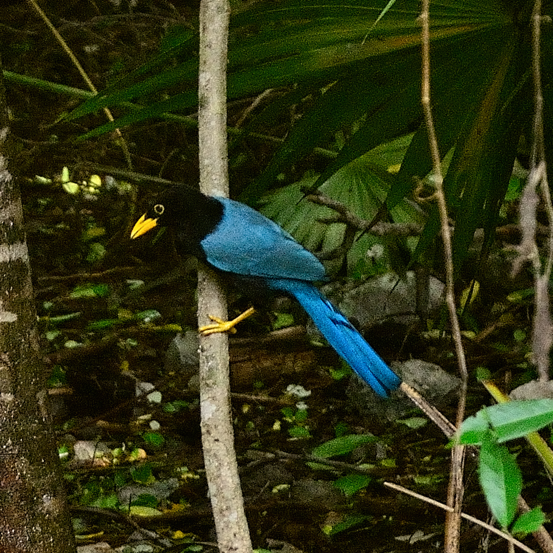
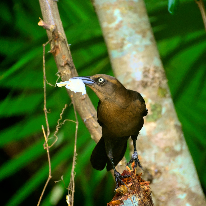
I’ve never been a bird watcher, but I am a bird lover, and I’ve always enjoyed taking pictures of them, even when I don’t have a clue as to the species. After-the-fact identification has never been easier: drag and drop just about any bird photo into the Google search bar, and nine times out of ten, you’ll get a hit. In this case, it took the search engine all of half a second to identify the bright blue bird with the yellow beak as a Yucatan Jay. The brown bird in the middle of his meal is a Great Tailed Grackle, and the pair of high flyers silhuetted against the clouds are Frigate Birds. Pretty cool!

Tulum is a fantastic place to visit, in spite of the usual crowds. We can only imagine what it would have been like when it was still in use, with all the sights, sounds, and smells of a living city teeming with people, with the kings and nobles in their palaces, and the priests in their temples. What a different world that was, and not so very long ago.

Click the link to launch a Full Screen slide show featuring an assortment of my favorite photos from Tulum. These super-sized slides are best viewed on a full sized monitor or a tablet. They’re not properly configured for a Mobile browser.

Note: This is a revised and expanded version of a previous post that was titled: Tulum: The Mayan City by the Sea

Unless otherwise noted, all of these photographs are my original work, and are protected by copyright. They may not be duplicated for commercial purposes.

READ MORE LIKE THIS:

This is an interactive Table of Contents. Click the thumbnails to open the pages.

ON THE ROAD IN MEXICO

MEXICAN ROAD TRIP: HOW TO PLAN AND PREPARE FOR A DRIVE TO THE YUCATAN

The published threat levels are a “full-stop” deal breaker for the average tourist. That’s unfortunate, because Mexican road trips are fantastic! Yes, there are risks, but all you have to do to reduce those risks to to an acceptable level is follow a few simple guidelines.  

 <<CLICK to Read More!>>

Mexican Road Trip: Heading South, From Laredo to Villahermosa

When it was our turn, soldiers in SWAT gear surrounded my Jeep, and an officer with a machine gun gestured for me to roll down my window. He asked me where we were going. I’d learned my lesson in customs, and knew better than to mention the Yucatan. “We’re going to Monterrey,” I said, without elaborating.

He checked our ID’s and our travel documents, then handed them back. “Don’t stop along the way,” he advised. “You need to get off this road and to a safe place as quickly as you can!”

<<CLICK to Read More!>>

Mexican Road Trip: Zapatista Road Blocks in Chiapas

“Good morning,” I said. “We’re driving to Palenque. Will you allow us to pass?”

The leader of the group, a young Mayan lad, walked up beside my Jeep, and fixed me with a menacing glare. “The road is closed,” he said, keeping his hand on the hilt of his machete. “By order of the Ejército Zapatista de Liberación Nacional!”

“Is it closed to everyone?” I asked innocently. “How about if we pay a toll? How much would the toll be?”

He gave me an even more menacing glare. “That will cost you everything you’ve got,” he said gruffly, brandishing his machete, while his companions did the same.

<<CLICK to Read More!>>

Mexican Road Trip: Mayan Ruins and Waterfalls in the Lacandon Jungle

The next morning, we were waiting at the entrance to the Archaeological Park a half hour before they opened for the day. We were the only ones there, so they let us through early, and I had the glorious privelege of photographing that wonderful ruin in the golden light of early morning, without a single fellow tourist cluttering my view.

<<CLICK to Read More!>>

Mexican Road Trip: Merida and the Meridanos 

Merida is the largest city in southern Mexico, with a population of almost a million. Statistically, Yucatan is the safest of Mexico’s states, and Merida is widely considered the safest of all Mexico’s cities.

<<CLICK to Read More!>>

Mexican Road Trip: Cancún, Tulum, and the Riviera Maya

The millions of tourists who fly directly to Cancún from the U.S. or Canada are seeing the place out of context. They can’t possibly appreciate the fact that they’re 2,000 miles south of the border; a whole country, a whole culture, a whole history away from the U.S.A. Just looking around, on the surface? The second largest city in southern Mexico could easily pass for a beach town in Florida.

<<CLICK to Read More!>>

Mexican Road Trip: Circling the Yucatan, from Quintana Roo to Campeche

The Castillo at Muyil isn’t huge, as Mayan pyramids go, topping out at just over 50 feet, but it’s definitely imposing. Try to imagine: the equivalent of a five story building, with a three story grand staircase, just appearing, out in the middle of nowhere? Boo-yah!

<<CLICK to Read More!>>

Mexican Road Trip: Edzná, and Campeche, Where They Dance La Guaranducha

La Guaranducha, a traditional dance from Campeche, is a celebration of life, community, and the joy of existence. On stage, there was a group of young men and women in traditional dress, but it was clear that the guys were little more than props, because all eyes were on the girls. So colorful, and so elegant, hiding coyly behind their pleated, folding hand fans.

<<CLICK to Read More!>>

Mexican Road Trip: Adventures Along the Puuc Route

All of these communities in the Puuc region were allied, politically, culturally, economically, and socially. The Puuc was the cradle of the Golden Age of the Maya. Labna and Sayil were among the brightest jewels in the crown of a realm that never quite coalesced into an empire.

<<CLICK to Read More!>>

Mexican Road Trip: The Road to Bonampak

Rainwater seeping through the limestone walls of the temple soaked the Bonampak Murals with a mineral-rich solution that, each time it dried, left behind a sheen of translucent calcite. The built-up coating protected the paintings for more than 1200 years. As a result, we’re left with the finest examples of ancient art from the Americas to have survived into our modern era.

<<CLICK to Read More!>>

Mexican Road Trip: Crossing the Chiapas Highlands, to San Cristobal de las Casas

MX 199 crosses the Chiapas Highlands from Palenque to San Cristobal de las Casas. The distance is only 132 miles, but it’s 132 miles of curvy mountain roads with switchbacks, steep grades, slow trucks, and villages chock-a-block with topes and bloqueos, unofficial road blocks. Everything I read, and everything I heard, described the drive as alternatively spectacular, dangerous, and fascinating, in seemingly equal measure.

<<CLICK to Read More!>>

Mexican Road Trip: Cruising the Sierra Madre, from San Cristobal to Oaxaca

Today, we’d be driving as far as the city of Oaxaca, 380 miles of curves, switchbacks, and rolling hills that would require at least ten hours of our full attention, crossing the Sierra Madre de Chiapas, and entering the rugged, agave-studded landscape of the Sierra Madre de Oaxaca. If you’d like to know what that was like, read on! 

<<CLICK to Read More!>>

Mexican Road Trip: Flashing Lights in the Rear View: Officer Plata and La Mordida

This post is a work in progress. Anticipated publication in February, 2025.

<<CLICK to Read More!>>

Mexican Road Trip: Three Days of the Dead in San Miguel de Allende

This post is a work in progress. Anticipated publication in February, 2025.

<<CLICK to Read More!>>

Mexican Road Trip: Back to the Border: San Miguel de Allende to Eagle Pass

This post is a work in progress. Anticipated publication in March, 2025.

<<CLICK to Read More!>>

Southern Colonials: Merida, Campeche, and San Cristobal

Visiting the Spanish Colonial cities of Mexico is almost like traveling back in time. Narrow cobblestone streets wind between buildings, facades, and stately old mansions that date back three hundred years or more, along with beautiful plazas, parks, and soaring cathedrals, all of similar vintage.

<<CLICK to Read More!>>

San Miguel de Allende, Mexico’s Colonial Gem

If you include the chilangos, (escapees from Mexico City), close to 20% of the population of San Miguel de Allende is from somewhere else, a figure that includes several thousand American retirees.

<<CLICK to Read More!>>

Day of the Dead in San Miguel de Allende

In San Miguel de Allende, they’ve adopted a variation on the American version of Halloween and made it a part of their Day of the Dead celebration. Costumed children circle the square seeking candy hand-outs from the crowd of onlookers. It’s a wonderful, colorful parade that’s all about the treats, with no tricks!

<<CLICK to Read More!>>

IN THE LAND OF THE MAYA

Palenque: Mayan City in the Hills of Chiapas

Palenque! Just hearing the name conjures images of crumbling limestone pyramids rising up out of the the jungle, of palaces and temples cloaked in mist, ornate stone carvings, colorful parrots and toucans flitting from tree to tree in the dense forest that constantly encroaches, threatening to swallow the place whole.

<<CLICK to Read More!>>

Uxmal: Architectural Perfection in the Land of the Maya

The Pyramid of the Magician is one of the most impressive monuments I’ve ever seen. There’s a powerful energy in that spot–maybe something to do with all the blood that was spilled on the altars of human sacrifice at the top of those impossibly steep steps–but more than any building or other structure at any ancient ruin I’ve ever visited, more than any demonic ancient sculpture I’ve ever seen, that pyramid at Uxmal quite frankly scared the hell out of me!

<<CLICK to Read More!>>

The Mayan City of Edzná: First House of the Itzás

The Mayan Edzná is nothing less than epic, lyrical poetry, an extraordinary sonnet comprised of temples and palaces carved in stone that have stood, in regal grandeur, for more than a thousand years.

<<CLICK to Read More!>>

Photographer’s Assignment: Chichén Itzá

To get the best photos, arrive at the park before it opens at 8 AM. There will only be a handful of other visitors, and you’ll have the place practically all to yourself for as much as two hours! Take your time composing your perfect shot.There won’t be a single selfie stick in sight.

<<CLICK to Read More!>>

Chichén Itzá: Requiem for the Feathered Serpent

The feathered serpent with the unquenchable thirst for blood may be gone now, or at least fallen out of favor, but as long as the ruins of this ancient city remain standing, he won’t be forgotten.

<<CLICK to Read More!>>

Tulum: The City that Greets the Dawn

Tulum is not all that large, as Mayan sites go, but its spectacular location, right on the east coast of the Yucatan Peninsula, makes it one of the best known, and definitely one of the most picturesque. 

<<CLICK to Read More!>>

Cobá and Muyil: Mayan Cities in Quintana Roo

Cobá was a trading hub, positioned at the nexus of a network of raised stone and plaster causeways known as the sacbeob, the white roads, some of which extended for as much as 100 kilometers, connecting far-flung Mayan communities and helping to cement the influence of this powerful city.

<<CLICK to Read More!>>

Becan and Chicanná: Mayan Cities in the Rio Bec Style

Much about the Rio Bec architectural style was based on illusion: common elements include staircases that go nowhere and serve no function, false doorways into alcoves that end in blank walls, and buildings that appear to be temples, but are actually solid structures with no interior space.

<<CLICK to Read More!>>

The Puuc Hills: Apex of Mayan Architecture

The Puuc style was a whole new way of building. The craftsmanship was unsurpassed, and some of the monumental structures created in this period, most notably the Governor’s Palace at Uxmal, rank among the greatest architectural achievements of all time.

<<CLICK to Read More!>>

The Amazing Mayan Murals of Bonampak

Out of that handful of Mayan sites where mural paintings have survived, there is one in particular that stands head and shoulders above the rest. One very special place. Down by the Guatemalan border, in a remote corner of the Mexican State of Chiapas: a small Mayan ruin known as Bonampak.

<<CLICK to Read More!>>

A shout out to my old friend Mike Fritz (aka Mr. Whiskers), my shotgun rider on my Mexican Road Trip. “Drive to the Yucatan and See Mayan Ruins” was at the top of my post-retirement bucket list, right after “Drive the Alaska Highway and see Denali.” We checked off the whole Yucatan thing in a major way, and Mike was a heck of a good sport about it.

Road trips with old friends are the absolute best. We laugh and we laugh until we run out of breath, and laughter is good for the soul!

There’s nothing like a good road trip. Whether you’re flying solo or with your family, on a motorcycle or in an RV, across your state or across the country, the important thing is that you’re out there, away from your town, your work, your routine, meeting new people, seeing new sights, building the best kind of memories while living your life to the fullest.

Are you a veteran road tripper who loves grand vistas, or someone who’s never done it, but would love to give it a try? Either way, you should consider making the Southwestern U.S. the scene of your own next adventure.

A few years ago I wrote a book about road trips in Arizona and New Mexico that’s a lot like this website, packed with interesting information, and illustrated with beautiful photographs. Check it out! You can find it on Amazon, and at all other major booksellers.

ALASKA ROAD TRIP:

Alaska Road Trip: Driving to the Top of the World

The rough dirt road gave way to a newly paved modern highway. This was it, the Top of the World, and right on cue, the haze peeled back, just enough to give me a glimpse of the beauty my friends assured me would be there…

Alaska Road Trip: The Grand Circle: Wrangell-St. Elias National Park

So, just exactly how big is Wrangell-St. Elias National Park? You could combine Yellowstone with Yosemite, throw in the entire country of Switzerland, and you still wouldn’t match it in terms of size.

Alaska Road Trip: The Grand Circle: Anchorage and the Kenai Peninsula

The massive ice field in the park’s wild interior has spawned dozens of glaciers which, over the course of many millenia, have carved the landscape into fjords so heart-breakingly beautiful, humpback whales swim all the way from Hawaii just to cavort in the deep blue water.

Alaska Road Trip: The Grand Circle: From Tok to Denali

There are no icy mountains looming on the horizon, and Fairbanks is nowhere near Alaska’s ruggedly beautiful coast. The true beauty in Alaska’s second city is found below the surface, in the spirit and resiliance of the people who make the place their home.

Alaska Road Trip: Driving Alaska’s Grand Circle

Most of the major towns in Alaska, as well as three of the state’s incredible National Parks, can all be reached by driving Alaska’s Grand Circle: a loop route beginning in Tok that utilizes all four segments (1082 miles) of Alaska’s Interstate Highway system.

Kenai Fjords National Park: Exit Glacier: Up Close and Personal

Compared to the huge tidewater glaciers that flow directly into the sea along the coast of Kenai Fjords, Exit Glacier is just a baby–a baby that’s getting smaller every year–but it’s still big enough to permanently alter the landscape through which it passes.

Kenai Fjords National Park: Seabirds, Glaciers, and Whales on the Wild Coast of Alaska

As the tremendous weight of the moving glacier pushes forward, the pressure buckles the ice into fantastic pillars and columns, like frozen fairy castles gleaming translucent blue as the suspended glacial sediment refracts the sunlight.

Two-Foot High Kick: World Eskimo Indian Olympics

Contestants take a running leap, then they make this crazy jackknife move, touch the ball suspended high above the floor with both feet, then come back down and stick the landing. If that sounds difficult? You have no idea.

Dreaming of Denali

When I drove my Jeep to Alaska that first summer after I retired, my primary goal, the single most important thing I wanted to do, was to see Denali, the biggest mountain in North America.

Chena Hot Springs: A Fairbanks Original

The Chena hot spring puts out steaming water at a temperature of 150 degrees, producing enough power to meet all the needs of the resort, as well as filling the hot springs pools used by the guests. In addition to the lodge and restaurant, they offered camping and horseback riding, and they had exhibits featuring sled dogs, greenhouses, ice sculptures, and geothermal energy.

The Alaska Highway: Day 4: Beaver Creek to Fairbanks

Delta Junction, the end of the Al-Can, was only 200 miles away, and the border? Twenty miles, maybe half an hour, and I was finally going to cross into Alaska! I’d been on the road more than three weeks, and in just half a day more, I’d be in Fairbanks.

The Alaska Highway: Day 3: Whitehorse to Beaver Creek

Approaching the mountains, I started pulling over with serious frequency, taking LOTS of photos! Mountains, clouds, lakes, flowers—I was pretty sure I must have died and gone to heaven, but I couldn’t for the life of me remember the fiery crash.

The Alaska Highway: Day 2: Fort Nelson to Whitehorse

Every time I rounded a curve in the road there was another stupendous vista; it was nothing short of astonishing! I was literally yipping out loud, and a couple of times I actually pulled over and stopped while I pounded on my chest to “re-start” my heart!

The Alaska Highway: Day 1: Dawson Creek to Fort Nelson

Past Fort St. John, the terrain got a lot wilder. No more towns, very few people, and very little traffic. Saw a few U.S. license plates, Michigan, California, Oregon, South Carolina; people that were obviously headed to Alaska!

The Alaska Highway: Prelude: The Road to Dawson Creek

Even if you start in Seattle, the closest American city, it’s still more than 800 miles to Dawson Creek, wending your way that much further north, so far north that there will be a noticeable change in the hours of daylight. It’s the latitude that distinguishes the north country, including every bit of Alaska. Dawson Creek is where it all begins.

Follow the Fireweed

Visualize a summertime journey through that part of the world, a world filled with mountains and glaciers and boreal forests, ice blue rivers, turquoise lakes, and billowing clouds that fill the sky. Imagine your vision as a beautiful piece of music. The fundamental, underlying theme of that symphony would be a gently rising swell of perfect harmony, pinkish lavender in its hue.

MEXICAN ROAD TRIP (IN THE LAND OF THE MAYA):

Mexican Road Trip: Back to the Border: San Miguel de Allende to Eagle Pass

Saltillo was our crossroads: if we turned east here, we’d be retracing our previous route to the border at Nuevo Laredo (along the Highway of Death). This time, we knew better, so we turned north, toward Monclova, and Piedras Negras.

Mexican Road Trip: Three Days of the Dead in San Miguel de Allende

By mid-afternoon, the Jardin was beginning to fill with people. Painted faces were literally everywhere! It was like a costume party, but the venue wasn’t some hall or other indoor space, it was the whole entire town! Mike and I were definitely getting into the spirit of the thing–but we still drew the line at the notion of painting our beards…

Dia de Los Muertos: A Gallery of Photographs

A smorgasbord of colorful images, capturing the essence of the vibrant festival known as the Dia de Los Muertos, in the charming colonial city of San Miguel de Allende.

Mexican Road Trip: Flashing Lights in the Rear View: Officer Plata and La Mordida

As we drove away from the toll plaza, a State Police car that had been parked off to one side made a fast U-Turn and started following me. A moment later, he turned on his flashers and gave me a short blast on his siren, motioning for me to pull over. Two uniformed policemen got out, and approached me on the driver’s side. One of them hung back, apparently checking out my license plate before making a phone call.

I wasn’t sure if I was being stopped for some infraction, or if these guys were just fishing…

Mexican Road Trip: Cruising the Sierra Madre, from San Cristobal to Oaxaca

Today, we’d be driving as far as the city of Oaxaca, 380 miles of curves, switchbacks, and rolling hills that would require at least ten hours of our full attention, crossing the Sierra Madre de Chiapas, and entering the rugged, agave studded landscape of the Sierra Madre de Oaxaca. If you’d like to know what that was like, read on!

Mexican Road Trip: Crossing the Chiapas Highlands, to San Cristobal de las Casas

MX 199 crosses the Chiapas Highlands from Palenque to San Cristobal de las Casas. The distance is only 132 miles, but it’s 132 miles of curvy mountain roads with switchbacks, steep grades, slow trucks, and villages chock-a-block with topes and bloqueos, unofficial road blocks. Everything I read, and everything I heard, described the drive as  alternatively spectacular, dangerous, and fascinating, in seemingly equal measure.

Mexican Road Trip: The Road to Bonampak

Rainwater seeping through the limestone walls of the temple soaked the Bonampak Murals with a mineral-rich solution that, each time it dried, left behind a sheen of translucent calcite. The built-up coating protected the paintings for more than 1200 years. As a result, we’re left with the finest examples of ancient art from the Americas to have survived into our modern era.

Mexican Road Trip: Adventures along the Puuc Route

All of these communities in the Puuc region were allied, politically, culturally, economically, and socially. The Puuc was the cradle of the Golden Age of the Maya. Labna and Sayil were among the brightest jewels in the crown of a realm that never quite coalesced into an empire.

Mexican Road Trip: Edzná, and Campeche, Where They Dance La Guaranducha!

La Guaranducha, a traditional dance from Campeche, is a celebration of life, community, and the joy of existence. On stage, there was a group of young men and women in traditional dress, but it was clear that the guys were little more than props, because all eyes were on the girls. So colorful, and so elegant, hiding coyly behind their pleated, folding hand fans.

Mexican Road Trip: Circling the Yucatan, from Quintana Roo to Campeche

The Castillo at Muyil isn’t huge, as Mayan pyramids go, topping out at just over 50 feet, but it’s definitely imposing. Try to imagine: the equivalent of a five story building, with a three story grand staircase, just appearing, out in the middle of nowhere? Boo-yah!

Mexican Road Trip: Cancun, Tulum, and the Riviera Maya

The millions of tourists who fly directly to Cancun from the U.S. or Canada are seeing the place out of context. They can’t possibly appreciate the fact that they’re 2,000 miles south of the border; a whole country, a whole culture, a whole history away from the U.S.A. Just looking around, on the surface? The second largest city in southern Mexico could easily pass for a beach town in Florida.

Mexican Road Trip: Uxmal vs Chichén Itzá

From the parking lot, the building where they sell the tickets to Uxmal looks a bit like the entrance to a shopping mall, or a multiplex, but the moment you step through the door, you’ll discover that it’s actually a time machine. That entryway is a portal to the world of the ancient Maya, a thousand years into the past. 

Mexican Road Trip: Merida and the Meridanos

Merida is the largest city in southern Mexico, with a population of almost a million. Statistically, Yucatan is the safest of Mexico’s states, and Merida is widely considered the safest of all Mexico’s cities.

Mexican Road Trip: Mayan Ruins and Waterfalls in the Lacandon Jungle

The next morning, we were waiting at the entrance to the Archaeological Park a half hour before they opened for the day. We were the only ones there, so they let us through early, and I had the glorious privelege of photographing that wonderful ruin in the golden light of early morning, without a single fellow tourist cluttering my view.

Mexican Road Trip: Zapatista Road Blocks in Chiapas

“Good morning,” I said. “We’re driving to Palenque. Will you allow us to pass?”

The leader of the group, a young Mayan lad, walked up beside my Jeep, and fixed me with a menacing glare. “The road is closed,” he said, keeping his hand on the hilt of his machete. “By order of the Ejército Zapatista de Liberación Nacional!”

“Is it closed to everyone?” I asked innocently. “How about if we pay a toll? How much would the toll be?”

He gave me an even more menacing glare. “That will cost you everything you’ve got,” he said gruffly, brandishing his machete, while his companions did the same.

Mexican Road Trip: Heading South, from Laredo to Villahermosa

When it was our turn, soldiers in SWAT gear surrounded my Jeep, and an officer with a machine gun gestured for me to roll down my window. He asked me where we were going. I’d learned my lesson in customs, and knew better than to mention the Yucatan. “We’re going to Monterrey,” I said, without elaborating.

He checked our ID’s and our travel documents, then handed them back. “Don’t stop along the way,” he advised. “You need to get off this road and to a safe place as quickly as you can!”

Mexican Road Trip: How to Plan and Prepare for a Drive to the Yucatan

The published threat levels are a “full-stop” deal breaker for the average tourist. That’s unfortunate, because Mexican road trips are fantastic! Yes, there are risks, but all you have to do to reduce those risks to to an acceptable level is follow a few simple guidelines.

Day of the Dead in San Miguel de Allende

In San Miguel de Allende, they’ve adopted a variation on the American version of Halloween and made it a part of their Day of the Dead celebration. Costumed children circle the square seeking candy hand-outs from the crowd of onlookers. It’s a wonderful, colorful parade that’s all about the treats, with no tricks!

Chichén Itzá: Requiem for the Feathered Serpent

The feathered serpent with the unquenchable thirst for blood may be gone now, or at least fallen out of favor, but as long as the ruins of this ancient city remain standing, he won’t be forgotten.

The Mayan City of Edzná, First House of the Itzás

The Mayan city of Edzná is nothing less than epic, lyrical poetry, an extraordinary sonnet comprised of temples and palaces carved in stone that have stood, in regal grandeur, for more than a thousand years.

Uxmal: Architectural Perfection in the Land of the Maya

The Pyramid of the Magician is the most impressive monument I’ve ever seen. There’s a powerful energy in that spot–something to do with all the blood that was spilled on the altars of human sacrifice at the top of those impossibly steep steps. More than any ancient ruin I’ve ever visited, more than any demonic ancient sculpture I’ve ever seen, that pyramid at Uxmal flat scared the hell out of me!

The Amazing Mayan Murals of Bonampak

Out of that handful of Mayan sites where mural paintings have survived, there is one in particular that stands head and shoulders above the rest. One very special place. Down by the Guatemalan border, in a remote corner of the Mexican State of Chiapas: a small Mayan ruin known as Bonampak.

Palenque: Mayan City in the Hills of Chiapas

Palenque! Just hearing the name conjures images of crumbling limestone pyramids rising up out of the the jungle, of palaces and temples cloaked in mist, ornate stone carvings, colorful parrots and toucans flitting from tree to tree in the dense forest that constantly encroaches, threatening to swallow the place whole.

San Miguel de Allende, Mexico’s Colonial Gem

If you include the chilangos, (escapees from Mexico City), close to 20% of the population of San Miguel de Allende is from somewhere else, a figure that includes several thousand American retirees.

Southern Colonials: Merida, Campeche, and San Cristobal

Visiting the Spanish Colonial cities of Mexico is almost like traveling back in time. Narrow cobblestone streets wind between buildings, facades, and stately old mansions that date back three hundred years or more, along with beautiful plazas, parks, and soaring cathedrals, all of similar vintage.

The Puuc Hills: Apex of Mayan Architecture

The Puuc style was a whole new way of building. The craftsmanship was unsurpassed, and some of the monumental structures created in this period, most notably the Governor’s Palace at Uxmal, rank among the greatest architectural achievements of all time.

Becan and Chicanna: Mayan Cities in the Rio Bec Style

Much about the Rio Bec architectural style was based on illusion: common elements include staircases that go nowhere and serve no function, false doorways into alcoves that end in blank walls, and buildings that appear to be temples, but are actually solid structures with no interior space.

Coba and Muyil: Mayan Cities in Quintana Roo

Coba was a trading hub, positioned at the nexus of a network of raised stone and plaster causeways known as the sacbeob, the white roads, some of which extended for as much as 100 kilometers, connecting far-flung Mayan communities and helping to cement the influence of this powerful city.

Photographer’s Assignment: Chichen Itza

To get the best photos, arrive at the park before it opens at 8 AM. There will only be a handful of other visitors, and you’ll have the place practically all to yourself for as much as two hours! Take your time composing your perfect shot.There won’t be a single selfie stick in sight.

Mexican Road Trip, circa 2015

There are truckloads of soldiers on the highways, as well as roving pickup trucks with 50 Caliber machine guns mounted in their beds, and of course there are the checkpoints, where you’ll be stopped and surrounded by armed men in SWAT gear. It can be intimidating, to say the least, if you’ve never experienced that sort of thing before.

ARIZONA AND NEW MEXICO:

San Xavier del Bac: The White Dove of the Desert

San Xavier has all of the traditional elements of a Spanish Colonial church, along with many others that are quite unique. The craftsmanship of the original building is superb, and features many fascinating details.

Granada Park: An Avian Oasis in the Heart of Phoenix

Granada Park is a City Park that’s adjacent to a Mountain Preserve. Its location, along with certain other advantages, make it unique in some very specal ways.

A Sunset at White Sands

Dropping down out of the Sacramento Mountains near Alamogordo, the sky was filled with the colors of the widest rainbow I’ve ever seen. Down on the flat, another rainbow came spearing down through the clouds before setting out in pursuit of a downpour, off in the middle distance.

New Mexico’s Golden Autumn

When you think of autumn foliage, the list of places that comes to mind is much more likely to include New England than New Mexico–but the Land of Enchantment is full of fall surprises!

Grand Canyon Rafting

You find a rope, any rope, and you grab on with both hands for all you’re worth. The river boils like the North Sea in a gale, great, rolling green waves and troughs. The raft plummets sideways into a hole fifteen feet deep, the outboard motor shrieks, a monster wave towering ten feet above your head comes crashing down across the deck, pummeling the passengers like a gigantic liquid fist that takes your breath away, leaving you suspended, time stopped, frozen in mid-scream.

Grand Canyon Rafting Expedition: Day One

The two rafts were shoved away from the beach until they floated free, and the boat drivers eased them into the middle of the channel.  We were mostly moving with the current, but the beach dropped behind us pretty quickly, and in a matter of minutes we were out there, rafting down the Colorado River, heading squarely into the enchanted depths of the Grand Canyon.

Grand Canyon Rafting Expedition: Day Two

The cliffs and buttes were a perfect composition, the different colored layers of stone were all but glowing in the afternoon light, and we had this incredible world all to ourselves, not another boat in sight. 

Grand Canyon Rafting Expedition: Day Three

The waters of the Little Colorado are a turquoise blue that is so startlingly bright it doesn’t even look real.  There’s a well-defined spot where that warm, turquoise blue water from the small river collides with the cold, deep green water flowing upstream from the big river. The two dramatically different colors mix, forming a shifting, swirling line of chartreuse.  That spot is the confluence. It’s magical, and utterly unique.

Grand Canyon Rafting Expedition: Day Four

I was still a little dazed by the whole thing, scenes of frothing, churning whitewater playing over and over in my head.  Fleecy white clouds were piling up above the canyon rim, nearly filling the narrow patch of sky, until the lowering sun set them afire, a Grand Canyon sunset display that was the finest we’d seen, worthy of the spectacular setting.  A fitting end to one of the most amazing days of my life.

Grand Canyon Rafting Expedition: Day Five

The trail meandered for a mile or so, finally giving us access to a series of perfect swimming holes.  There’s something about that exotic turquoise water that welcomes swimmers; the creek was cool, but far from cold, and a welcome change from the icy water in the river.  We stopped at an inviting spot to swim, relax, and eat our lunch. Sitting beside that creek, with our simple repast–it was like having a picnic in the Garden of Eden. 

Grand Canyon Rafting Expedition: Day Six

“Two Hander!” John called out, and we all clung to the ropes for dear life as the raft picked up speed.  We were headed straight for the boil of Lava Falls, roaring like a freight train, bearing down. We entered the churning whitewater dead center, then moved hard to the right to avoid the standing waves and the big holes in the middle of the channel.  We got good and drenched, almost like running under a series of waterfalls, bucking and lurching like crazy, but the whole thing was over in less than a minute. 

Grand Canyon Rafting Expedition: Day Seven

Immediately below that beach we hit Diamond Creek Rapid, then Travertine Rapid, where we pulled over to the bank at Travertine Canyon.  The creek that entered the river here flowed across huge, slippery boulders in a series of small waterfalls, and we had great fun taking turns standing in the flow, almost like a natural shower.

Grand Canyon Rafting Expedition: Day Eight

The river broadened as we approached Lake Mead, and at mile 278 we entered the lake itself.  Pearce Ferry was right there, and we were all pretty quiet as the rafts pulled in to shore for the last time. “Thrill of a lifetime” is a pretty strong statement, but it’s appropriate for this journey.  There’s nothing else like it.

SOUTH AMERICA:

Magnificent Monoliths: The Enigmatic Idols of San Agustin

At least 200 monolithic statues are preserved within the boundaries of the San Agustin Archaeological Park, along with 20 monumental burial mounds. Each statue is unique, but taken as a group they provide a fascinating overview of the rituals and beliefs of one of the earliest complex societies in the Americas. The enigmatic idols of San Agustin are truly unmatched among the world’s ancient monuments.

An Overabundance of Bowlers: A Brief History of the Headgear on the High Plateau

Andean natives have adapted to the intensity of the high altitude sun by taking a very simple precaution: everyone, almost without exception, wears a hat when they venture outdoors. From infants to ancients, everyone covers their head with something, ranging from shawls to leather helmets to proper English bowlers.

Chinchero: The Place Where Rainbows are Born

Candid portraits of villagers in traditional dress, taken in Chinchero, Peru in 1971, before the outside world intruded.

Children of the Altiplano

Candid portraits of Andean villagers taken in Peru and Bolivia in 1971. This set of photographs focuses on the children: their joy, and their innocence.

Puno Day Festival: A Centuries-Old Tradition on the Shores of Lake Titicaca

Historic photos of Peru’s Puno Day festival, taken in 1971. Included is the reenactment of the birth of the Inca empire on the shore of Lake Titicaca, with costumed dancers lining the streets of Puno.

Portraits of a People, Lost in Time

50 year old portraits of Andean natives in their traditional dress, taken in mountain villages not yet tainted by outside influences.

In the Vale of the Stone Monkeys: Peril and Petroglyphs in the Colombian Jungle

El Manco was easy to spot; he had a right arm that had been severed above the elbow, and that wasn’t his only problem. He was also missing his right eye, nothing there but an ugly knot of scar tissue. “Tough old bird” doesn’t begin to describe a hardscrabble character like Manco; he had a face with creases like a roadmap straight to his own personal version of hell.

Tumaco: The Arhuaco Connection

What we really know of history is like an ancient tapestry, worn, and threadbare, with missing patches confusing the grand design. When we make a new connection, we restore a missing thread, and little by little, thread by thread, we fill in those troublesome blanks.

Tairona Gold: The Curse of the Coiled Serpent

Paul dug with his hands then, finally sticking his arm into a hollow space, pulling out a dark object. Grinning at me from the bottom of his hole, he handed up what he’d found. A round blackware vessel representing a coiled serpent, open in the middle, with a spout at the top of the head. I’d seen a lot of Tairona artifacts, but I’d never seen anything remotely like that one.

Tairona Gold: The Rape of Bahia Concha

It was the Tairona gold that triggered a blood lust in the Spanish invaders, ultimately causing the destruction of the entire Tairona civilization. That cycle was repeated in modern times, when the lust for Tairona gold infected the guaqueros, causing the destruction of the last refuge of the Tairona ancestors, in one final humiliation, one last indignity: the RAPE of Bahia Concha!

Machu Picchu Sunrise

The five of us had Machu Picchu entirely to ourselves for at least twelve hours. It was like a dream, and a very fine dream, at that.

PHOTOGRAPHY:

Photographer’s Assignment: Mount Rainier

The road to Sunrise Park climbs into the foothills of Mount Rainier on the eastern side. The volcano is the biggest mountain around, and the treeless upper slopes, cloaked in glacial ice, catch and reflect the full brunt of the rising sun’s bright rays; a spectacle well worth the long drive, and the early wake-up call.

Photographer’s Assignment: Crater Lake

It simply isn’t possible to gaze upon Crater Lake and not be awed by the view. It’s like staring into the eye of the Creator, a heavenly vision reflected by water so clear, and so deep, and so intensely BLUE, you’ll find yourself neglecting to breathe.

Granada Park: An Avian Oasis in the Heart of Phoenix

Granada Park is a City Park that’s adjacent to a Mountain Preserve. Its location, along with certain other advantages, make it unique in some very specal ways.

Kenai Fjords National Park: Seabirds, Glaciers, and Whales on the Wild Coast of Alaska

As the tremendous weight of the moving glacier pushes forward, the pressure buckles the ice into fantastic pillars and columns, like frozen fairy castles gleaming translucent blue as the suspended glacial sediment refracts the sunlight.

Dreaming of Denali

When I drove my Jeep to Alaska that first summer after I retired, my primary goal, the single most important thing I wanted to do, was to see Denali, the biggest mountain in North America.

A Sunset at White Sands

Dropping down out of the Sacramento Mountains near Alamogordo, the sky was filled with the colors of the widest rainbow I’ve ever seen. Down on the flat, another rainbow came spearing down through the clouds before setting out in pursuit of a downpour, off in the middle distance.

Photographing the Sunrise at the Lincoln Memorial

The slightly elevated position of the Lincoln Memorial gives photographers a clear line of sight from every vantage point, with a multitude of options for interesting compositions. But if you want the very best light, and the smallest crowds, you’re going to have to get out there at sunrise!

The Many Moods of the Jefferson Memorial

As a subject for photographers, the Jefferson has it all: columns and curves, sculpture, carved inscriptions, a dome! The Tidal Basin serves as a reflecting pool, and, for a couple of weeks every spring, the whole business is surrounded by flowering cherry trees.

Washington D.C., By the Dawn’s Early Light

Each weekend I’d focus on a different monument, and I’d shoot them from every conceivable angle, before, during, and after the golden hour of the sunrise. Why the weekend? Because, grasshopper, on weekend mornings, there are no commuters, so there is no traffic, no parked cars, no people in the way of your photo shoot!

New Mexico’s Golden Autumn

When you think of autumn foliage, the list of places that comes to mind is much more likely to include New England than New Mexico–but the Land of Enchantment is full of fall surprises!

Blossoms by the Billions: Photographing the Cherry Blossoms in Washington D.C.

Shoot the flower buds when they first emerge, shoot them again when they’re in full florescence, and if you can swing it, one last time when they start to drop, and you have pink petals falling around you like rain…

Follow the Fireweed

Visualize a summertime journey through that part of the world, a world filled with mountains and glaciers and boreal forests, ice blue rivers, turquoise lakes, and billowing clouds that fill the sky. Imagine your vision as a beautiful piece of music. The fundamental, underlying theme of that symphony would be a gently rising swell of perfect harmony, pinkish lavender in its hue.

Antelope Canyon: Conjuring a Beam of Light: Take 2

Today, thanks to Instagram, Pinterest, Facebook, and all the other photo sharing sites out there, every human on the face of the earth knows about Antelope Canyon, and the volume of visitors has mushroomed into the millions. Instagram, alas, is its own worst enemy,

Buffalo Sunrise: Grand Teton National Park

We could have planned our photo shoot, set up for it, and no doubt we would have gotten even BETTER pictures. But if we’d done that? We would have missed out on the jaw-dropping surprise of a completely unexpected herd of wild buffalo! At sunrise! In the Grand Tetons! That kind of a surprise? It’s almost enough to make your eyeballs explode. It’s just about the very best feeling there is, in this whole big beautiful world!

Photographer’s Assignment: Chichen Itza

To get the best photos, arrive at the park before it opens at 8 AM. There will only be a handful of other visitors, and you’ll have the place practically all to yourself for as much as two hours! Take your time composing your perfect shot.There won’t be a single selfie stick in sight.

Antelope Canyon: Conjuring a Beam of Light

Ephemeral “God beams” appear like magic in the confined space, slanting across the canyon floor like spotlights on a theater stage, only to disappear after a few minutes as the earth spins another fraction of a degree, breaking the perfect alignment.

Antelope Canyon: Part 1

Slot canyons are formed, over the course of many thousands of years, when torrents of rainwater borne from the monsoon storms of summer sluice through channels and cracks in the soft sandstone. Powerful floods strike repeatedly, carving narrow, twisting pathways into the cross-bedded layers of rock, sculpting swirling formations that look like petrified waves.

TRIBAL LANDS:

Canyon de Chelly: The Oldest White House

At the center of the upper section is a large room, 12 by 20 feet, with a front wall that is 12 feet high and made of stone that is two feet thick. This wall was coated in white plaster, decorated with a yellow band, and it is this white wall, which can still be seen, that inspired the name La Casa Blanca, the White House, to this ancient dwelling that has endured in this place for nearly a thousand years.

Canyon de Chelly: Riding the Rainbow to the Universe: The Legend of Spider Woman

Viewing Spider Rock from below provides a dramatically different perspective on this extraordinary formation. From above, you’re looking down on the whole tableau, and Spider Rock, shorter than the soaring canyon walls, appears as one small part of the larger scene. From below, from the floor of the canyon looking up at it, you can see just how BIG the danged thing is. At 800 feet in height, it’s a good bit taller than your average 50 story sky scraper, and it completely dominates the landscape.

Canyon de Chelly: Part 4: The Road to Spider Rock

The twin pillars of Spider Rock were left behind, like a pair of stubborn hold-outs, when everything else around them slowly weathered away. To me, these are fingers of cosmic proportions, thrusting from the earth, pointing toward the heavens in a gesture of unity. When you view these monolithic towers, you will be captivated by their majesty, and by the sheer insolence of their improbable existence.

Canyon de Chelly: Blue Bull and Mummy Cave

300 feet above the canyon floor, there are two deep alcoves filled with ruins, and on a wide ledge between them, a large, multi-story pueblo, partially reconstructed, and quite impressive. The setting is a natural amphitheater, and the overall aspect of the place is simply stunning.

Canyon de Chelly: Standing Cow: A Home Among the Ruins

The hogan, much newer than the other structures, was built using sandstone bricks recycled from the surrounding ruins. Today, even though it’s not really ancient, Standing Cow is on all the maps, as much a part of the human landscape of Canyon de Chelly as the White House and the Mummy Cave.

Canyon de Chelly: Antelope House Ruin

Of all the ruins and other archaeological sites in Canyon de Chelly, Antelope House is the most thoroughly investigated. That’s at least partially due to simple ease of access: unlike most of the ruins in the canyon, all the primary structures at this site are at ground level. Researchers have found the remains of several different cultures in the stratified soil beneath the ruins, each group contributing to the timeline of an area that’s exceptionally rich in history.

Canyon de Chelly: Ruins and Rock Art

We got out, and walked through the trees to a place where a thirty-foot long segment of the sandstone cliff had crumbled away near the base, leaving a section of wall that was set back a couple of feet, protected by an overhang. We could see black pictographs of horses and riders filling that rough stone canvas from left to right.

Canyon de Chelly: Part 3: Canyon del Muerto

The left hand fork is the spectacular work of nature known as Canyon del Muerto. The star attraction of this route is the Mummy Cave Ruin, the largest in the area, built on a ledge between a pair of deep caves, high on the face of a cliff in an extraordinary natural amphitheater.

Canyon de Chelly: Where Canyons Collide

“First Ruin is right over there!” Sylvia pointed to our left, where segments of ancient adobe walls filled a natural alcove halfway up the side of the cliff.

“First Ruin. Wait, don’t tell me. Do they call it that because it’s the oldest?”

“No,” she said with a chuckle. “They call it First Ruin, because it’s the first ruin that we see!”

Canyon de Chelly: Kokopelli and the Lightning Spear

I was probably getting a bit starry-eyed at that point. Barely three miles into the canyon, we’d traveled a thousand years in just under a hundred minutes, and we were barely even underway!

Canyon de Chelly: Ancient Stories Etched in Stone

The petroglyphs we’d just seen, and those we were about to see, were an artistic expression of the highest order, representing the hopes, the dreams, and the spiritual quest of the ancients who created them. These symbols, laboriously etched in stone, were left there for our benefit, and if there are lessons to be learned, we’d be well advised to take heed.

Canyon de Chelly: A Timeless Journey into the Heart of the Navajo Nation

Our first stop was a prehistoric bulletin board Sylvia called Newspaper Rock. A smooth segment of cliff face coated with dark desert varnish, featuring an area at least forty feet wide filled hundreds of petroglyphs. The intriguing symbols were created hundreds of year ago by artists who pecked away the dark varnish, exposing the lighter colored rock underneath.

Canyon de Chelly: Part 2: Chinle Wash to the Junction

A Navajo guide can take you into the canyon in their SUV, or, if you prefer, you can join a guided hike, or a trail ride on horseback. The standard Jeep tours, which are the most popular, range from three to six hours in length. The longer tours cover the highlights of both Canyon De Chelly, and Canyon del Muerto.

Canyon de Chelly: The North Rim Drive

The payoff at the Overlook is a fabulous bird’s-eye view of a quite wonderful Anasazi ruin known as the Antelope House. You can still see the crumbling foundations of dozens of rooms, a tower, and at least four circular kivas, special rooms used by the Ancestral Pueblo people for religious ceremonies.

Canyon de Chelly: Overlooking the White House

The White House Overlook offers a fabulous panorama of the Canyon, and an unobstructed view of the White House, one of the best preserved ruins in the National Monument. Set into a sheer cliff striped with desert varnish, the tableau is instantly recognizable as one of the best-known photographs of Ansel Adams, who once described Canyon de Chelly as “the most beautiful place on earth.” He shot some of his favorite images from the canyon rim.

Canyon de Chelly: The South Rim Drive

The canyon is filled with fascinating contrasts between the cliff dwellings of the Anasazi and the archaic way of life of the Navajo. These views into the canyon literally transcend time.

Canyon de Chelly: Part 1: The Rim Drives

Canyon de Chelly is so much more interesting than the Grand Canyon, because it also has a history, a fascinating history that actually comes alive when you view it up close. Native people have lived in this canyon for almost 5,000 years, which is a very long time indeed, by any standard. What those ancients left behind is the most extraordinary concentration of cliff dwellings and rock art panels to be found anywhere in the desert southwest.

A Serendipitous Sunset at Shiprock

I noticed an odd rock formation coming up fast on the left side of the road, almost like a wall built of angular blocks. Shiprock was close, but hidden from view by the wall as I zoomed toward it. After I passed the odd formation, I stole a quick glance in my rearview mirror, and what I saw was a scene so other-wordly, it literally stopped me in my tracks:

Antelope Canyon: Conjuring a Beam of Light: Take 2

Today, thanks to Instagram, Pinterest, Facebook, and all the other photo sharing sites out there, every human on the face of the earth knows about Antelope Canyon, and the volume of visitors has mushroomed into the millions. Instagram, alas, is its own worst enemy,

Antelope Canyon: Conjuring a Beam of Light

Ephemeral “God beams” appear like magic in the confined space, slanting across the canyon floor like spotlights on a theater stage, only to disappear after a few minutes as the earth spins another fraction of a degree, breaking the perfect alignment.

Antelope Canyon: Part 1

Slot canyons are formed, over the course of many thousands of years, when torrents of rainwater borne from the monsoon storms of summer sluice through channels and cracks in the soft sandstone. Powerful floods strike repeatedly, carving narrow, twisting pathways into the cross-bedded layers of rock, sculpting swirling formations that look like petrified waves.