The primary occupation of all early humans was the gathering of food. For most, it was a full time job, while others had it easier, but none of them ever advanced beyond the basics until they found a way to solve that basic problem, by creating a reliable, sustainable surplus large enough to feed the whole group. That single development allowed population growth, and the luxury of loftier pursuits.

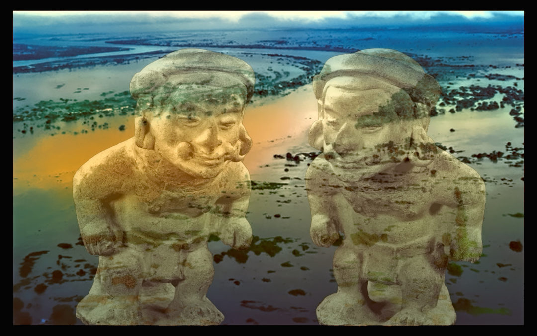
In the area near Tumaco, on the Pacific Coast of Colombia, early attempts at growing crops were thwarted by the rivers that frequently overflowed their banks, and tides that surged inland, sometimes for miles, washing everything away. Over time, they came up with a system of raised fields flanked by drainage ditches that allowed them to channel the excess water, and with that, their basic problem was solved.  The soil of the alluvial plain was exceptionally rich, so their harvests were exceptionally abundant. Since they no longer had to expend all their energy finding their next meal, a social structure evolved, along with an intricate system of beliefs. The end result was a ‘civilized’ way of life that was quite sophisticated, and unique to this small part of the ancient world, beginning more than 2,000 years ago.

The ebb and flow of floodwaters dictated Tumaco agricultural techniques, as well as the layout of their towns and villages. Communal houses and temples were built atop earthen platforms to keep everything dry when the waters rose. It was important to keep the graves of their dead safe as well, so they constructed massive platforms for use as cemeteries, ensuring that everything they buried stayed buried, well above the high water mark. Unlike many of their contemporaries, they did not build with stone. Their houses and temples were made of wood and thatch, materials that don’t survive the passage of time, so the only structures of any kind still remaining are the platforms, worn by the millennia into mounds that look like natural hills.

All of the mounds, but especially the tolas, the burial mounds, were loaded with archaeological remains. There were household items, stone tools, pottery of various types, and then, there was gold! Personal jewelry, like nose rings and ear rings, and finely wrought ceremonial objects, some of the finest gold work in the ancient Americas. Once the word got out, legions of tomb robbers descended, and the real archaeologists were outnumbered, a hundred to one. For every Tumaco archaeological site that has been properly, scientifically excavated, there are at least a hundred more that were destroyed by looters looking for gold, and for every guaquero that found it, there were at least a hundred more that did not. What they encountered instead were artifacts made of clay, odd little figurines depicting people, their daily lives, their infirmities, their heroes, as well as the beasts and demons of their elaborate mythology. Figurines and other artifacts unearthed by the scientists ended up in museums, while the finest, most elaborate pieces, which were almost invariably found by the looters, ended up in private collections. Either way, it is through those figurines, some intact, but most in fragments, that these all but forgotten people have come to be known.

For any artifact to have scientific value, you have to know the context, how, when, and where it was found; the nature of the site, what else was found with it; the stratigraphic sequence; anything that could be used to facilitate dating. Pieces offered for sale by antiquities dealers rarely have any of that, because the guaqueros who supply the market lack even the most rudimentary scientific expertise. For them, a good job is when they manage to dig something up without breaking it. Worse: most diggers are deliberately evasive about how and where their treasures were found, because they don’t want to give away the location of a good source! Without the context of its origins, an artifact is reduced to mere art, without the fact, but what’s done is done, and, with few exceptions, the Tumaco art is all that remains.

Note: the artifacts featured in these photographs were not from a single source. They represent an assortment of stylistic phases, and were originally recovered from an unknown number of different sectors in the region once occupied by the Tumacos. The one thing they do have in common: all of them were available for purchase in Bogotá, back in the early 1970’s.

FIGURINES:

Most of the figurines that have been recovered in the Tumaco area are broken; in many cases, they appear to have been deliberately smashed before they were buried, possibly in ritual sacrifice. Even the relatively complete examples are usually cracked or missing limbs, but they still provide a quite wonderful sense of the artistry that went into their manufacture.

A typical Tumaco figurine is made from fine-grained greyish clay, deposits of which have been found near the banks of area rivers. Pieces were produced using press-molds (see previous post), then finished by hand, fired, and painted. In some cases traces of the original pigment remain, but most Tumaco artifacts are plain gray, worn smooth by their lengthy burial in swampy ground.

That brings to mind a trick one of the antiquities dealers in Cali showed me, a test that he used to spot counterfeit copies of Tumaco figurines. He’d lick the back of the head, just one good lick, and he’d watch to see how long it took for the surface to absorb the moisture. If the wet spot disappeared quickly, the clay was too porous, and the piece wasn’t really old. If the wetness was absorbed slowly, he’d put the wet spot under his nose, and he’d inhale deeply. If it exuded an odor like moldering potting soil, that meant the clay was infused with the essence of the burial mound, and the artifact was probably real.


Click any photo to expand the image to full screen:

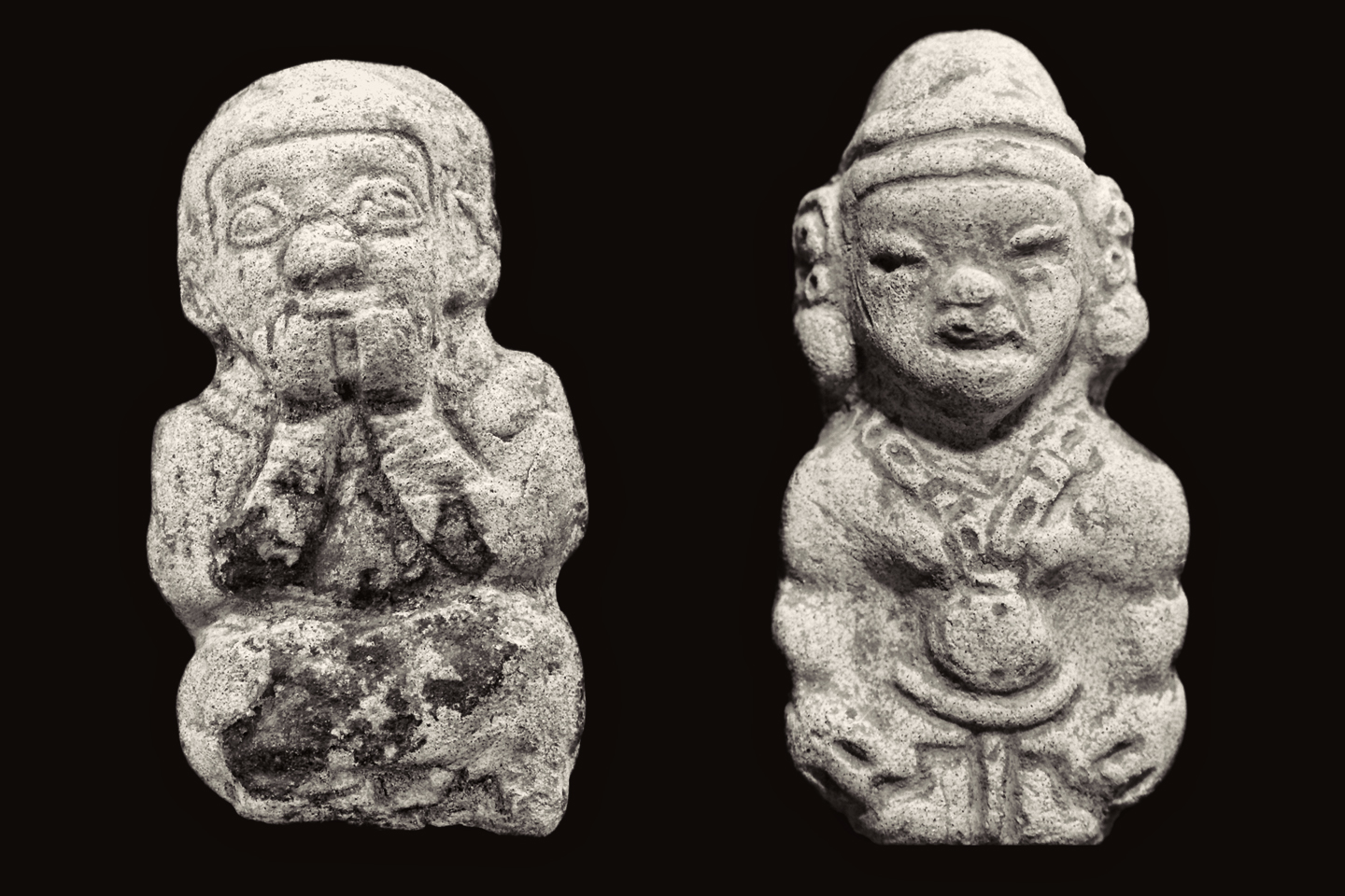
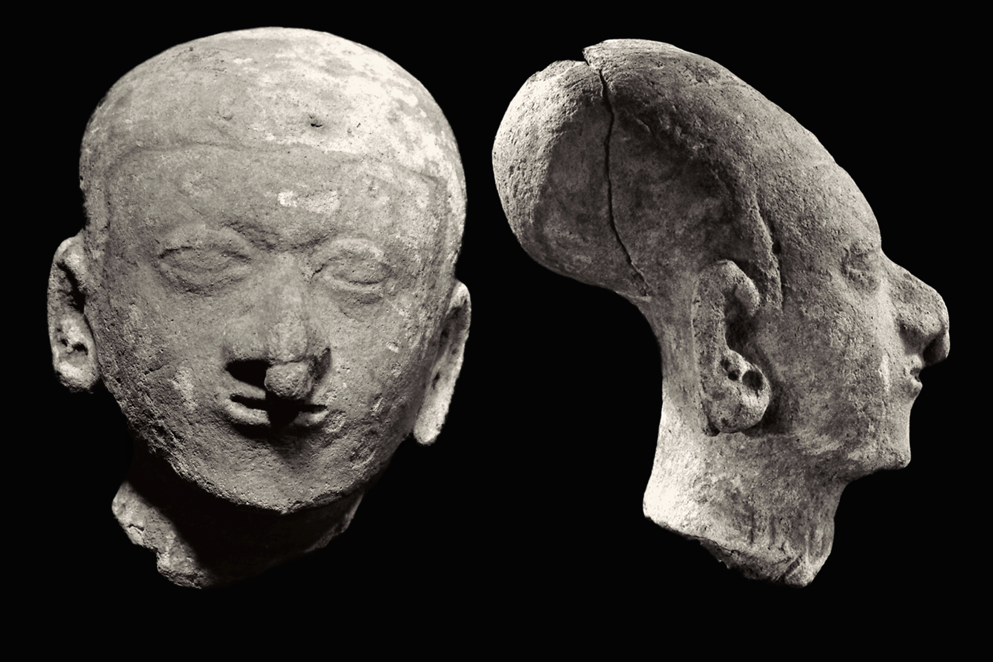
The simplest figurines are small, solid, and only finished on one side, like these two (above), both about 10 cm in height.

Other, more sophisticated figurines are also made with molds, but they are hollow. The earliest examples are relatively thick-walled, and not at all delicate. The hollow figurines will always have a good-sized hole poked into them somewhere, an air vent, so that they don’t explode when they’re fired.

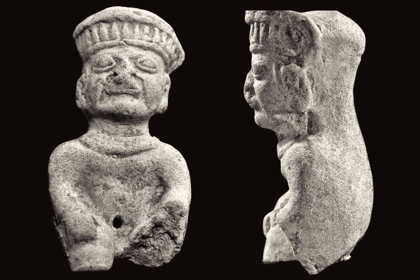
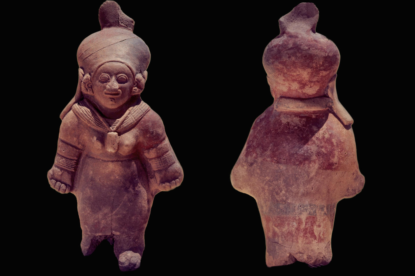
Often, it’s in the belly, where a navel would be, as is the case with this figurine of a Tumaco chief (above).

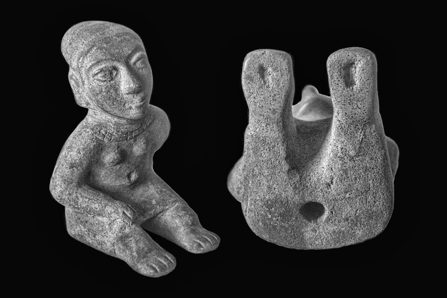
With others, like this figurine of a seated woman (above), the vent is concealed on the flat bottom of the piece.

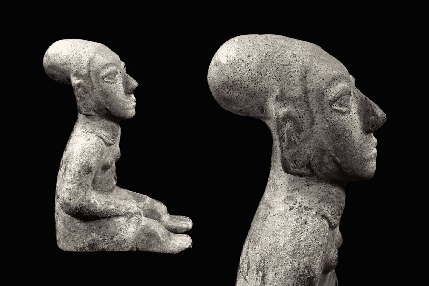
The woman’s head exhibits the swept back cranial deformation that was common among a number of different cultures in the New World, including the Maya–but if figurines such as this are a reliable indicator, the bizarre practice seems to have reached its peak with the Tumacos. They would bind the heads of infants during their early growth years, in order to permanently distort the shape of the child’s skull. The resulting flattened, exaggerated forehead was considered beautiful, and served as an unmistakable symbol of elevated social status; a peculiar distinction that was reserved for the elite, and for their favored offspring.

Tumaco ceramic art is remarkably sophisticated, utilizing a number of techniques that are considered quite advanced, but we can’t give them all the credit for any of it. The coastal regions of the ancient Americas were occupied by a lineage of increasingly developed populations, beginning thousands of years before the advent of the Tumacos, and there is evidence of wide-ranging trade, in ideas as well as in goods.

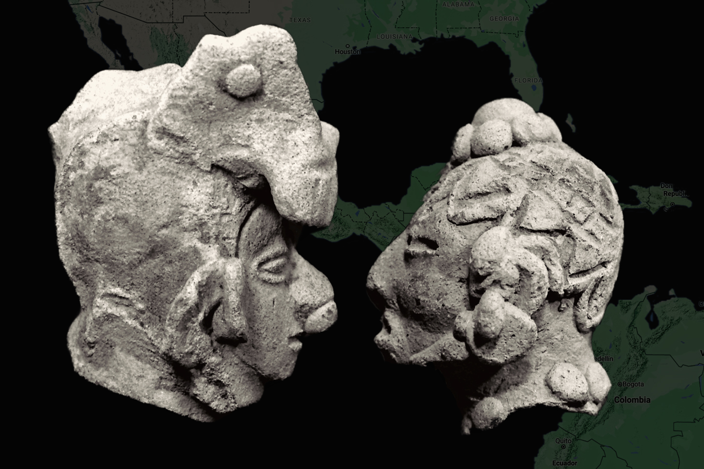
One group that was a contemporary of the Tumacos was the Jama-Coaque, people who lived very similar lives, but in the area just south of the Tumaco territory. Those ancients also produced figurines, using the same essential techniques, but the artifacts recovered from Jama-Coaque burials differ from their Tumaco counterparts in several ways.  Most notably, they used a different type of clay, more of a beige color, rather than gray, and very fine grained.

The molded details on Jama-Coaque pieces tend to be more sharply defined, and the original pigment seemed to adhere a bit better, so more of it has survived, as evidenced on the back side of this figurine of a standing woman (above).

Cranial deformation was practiced, and is depicted in Jama-Coaque figurines, but it is somewhat less pronounced (above).

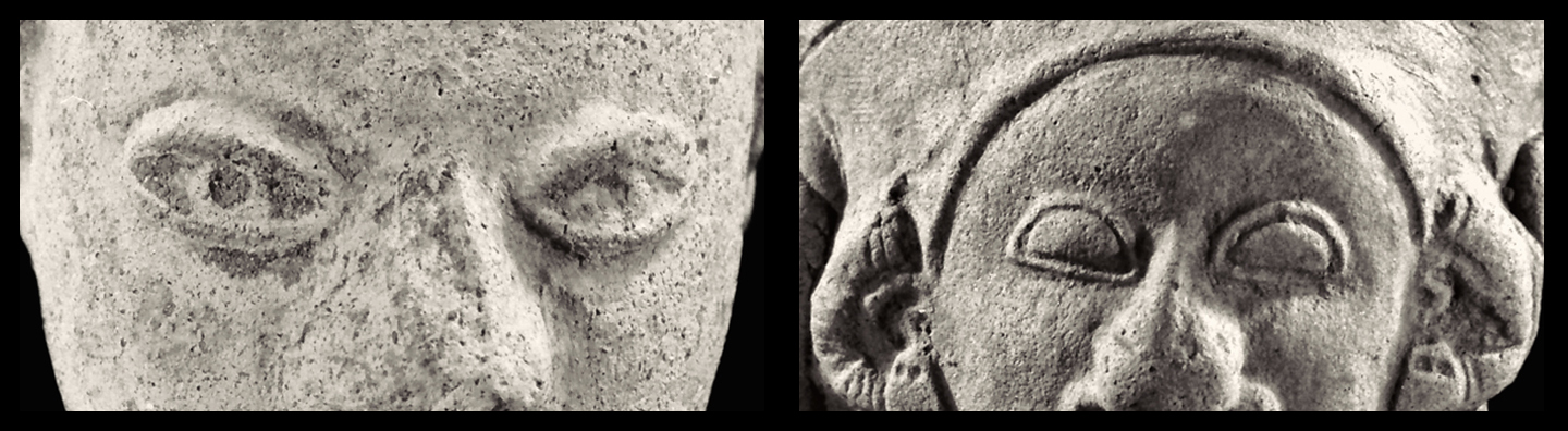
And then, there are the eyes: on most Tumaco human figurines, the eyes have a natural, ovoid shape, while Jama-Coaque pieces tend to be more rigidly stylized, with eyes shaped like a sideways letter D.

Such differences may seem minor, but they reflect important societal distinctions, and there is also the question of patrimony. Most Tumaco artifacts are from Colombia (the exception being pieces from the La Tolita sites in Ecuador), while ALL Jama-Coaque artifacts are from Ecuador. The laws prohibiting the trafficking of artifacts were enacted much sooner in Ecuador, so any Jama-Coaque (or La Tolita) pieces sold by Colombian antiquities dealers during the heyday of that trade were already black market, smuggled across the border from Esmeraldas.

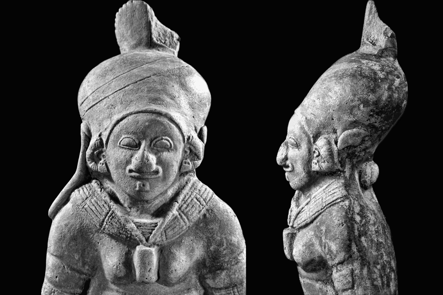
This next piece is an excellent example of an artistic format that was developed elsewhere, and subsequently adopted by The Tumacos for their own purposes. The double spout and bridge vessel is a traditional design in many parts of Peru; originally used to store drinking water, these vessels later developed into portrait jars, featuring stylized depictions of human faces, animals, and activities, ranging from warfare to graphic sex.

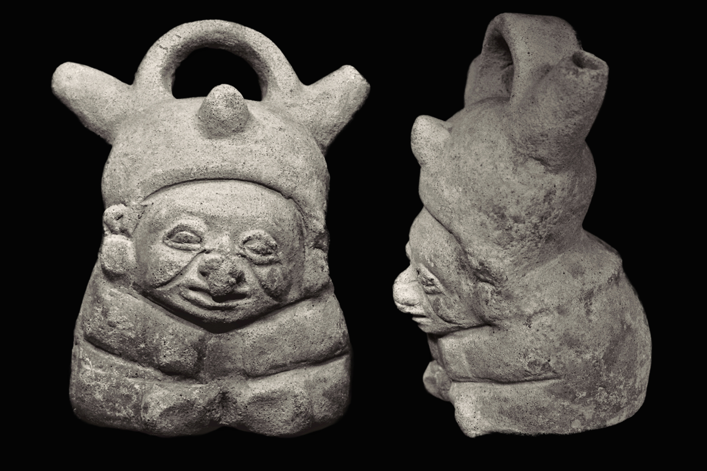
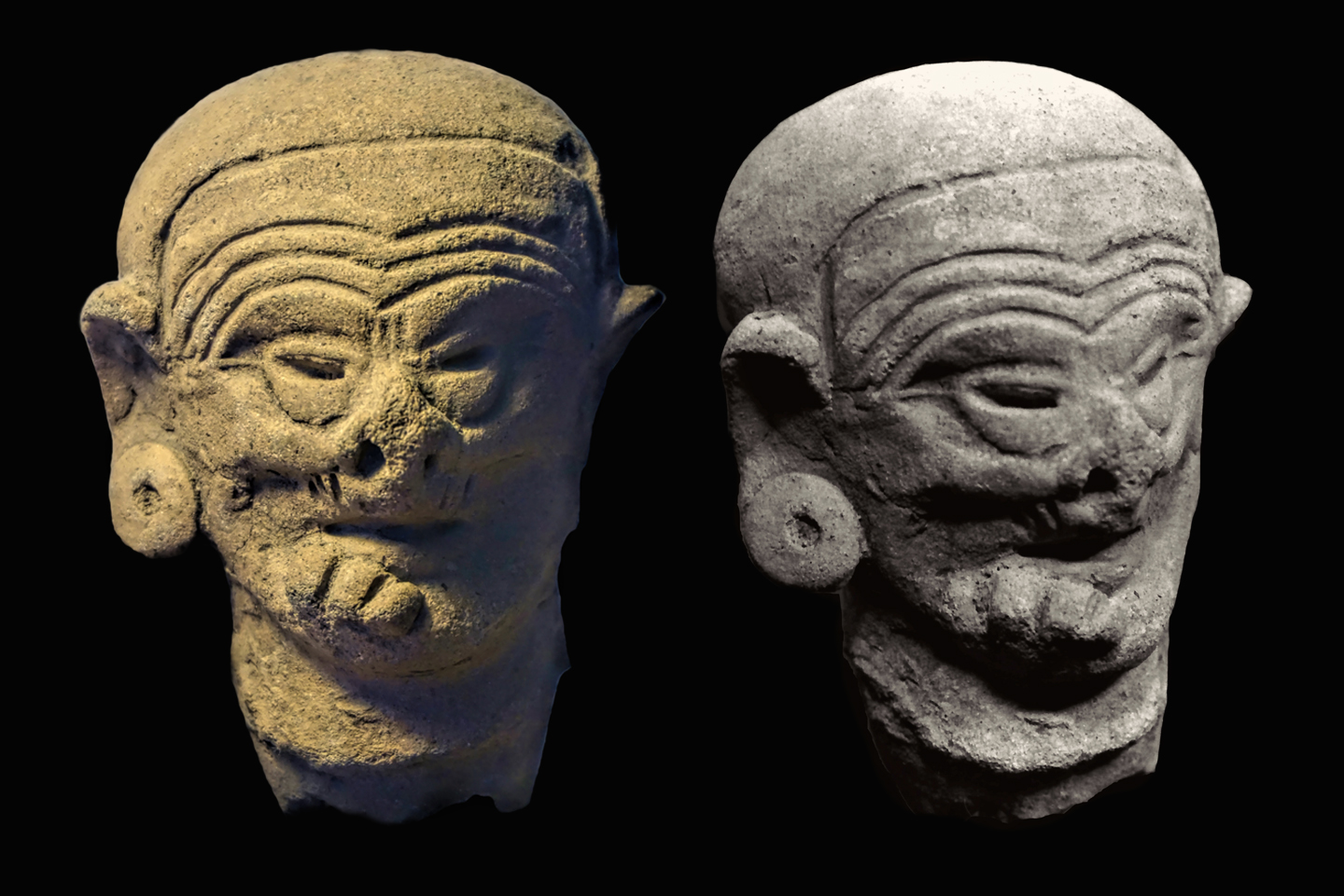
In this example (above), the Tumacos have grafted their own unique motifs onto the traditional form, creating a seated gentleman with a modestly swept back skull, a fitted cap, sagging cheeks that indicate age, and studs on either side of his nose, all typical features of Tumaco artifacts. This piece is hollow, 15.5 cm in height, and in unusually good condition.

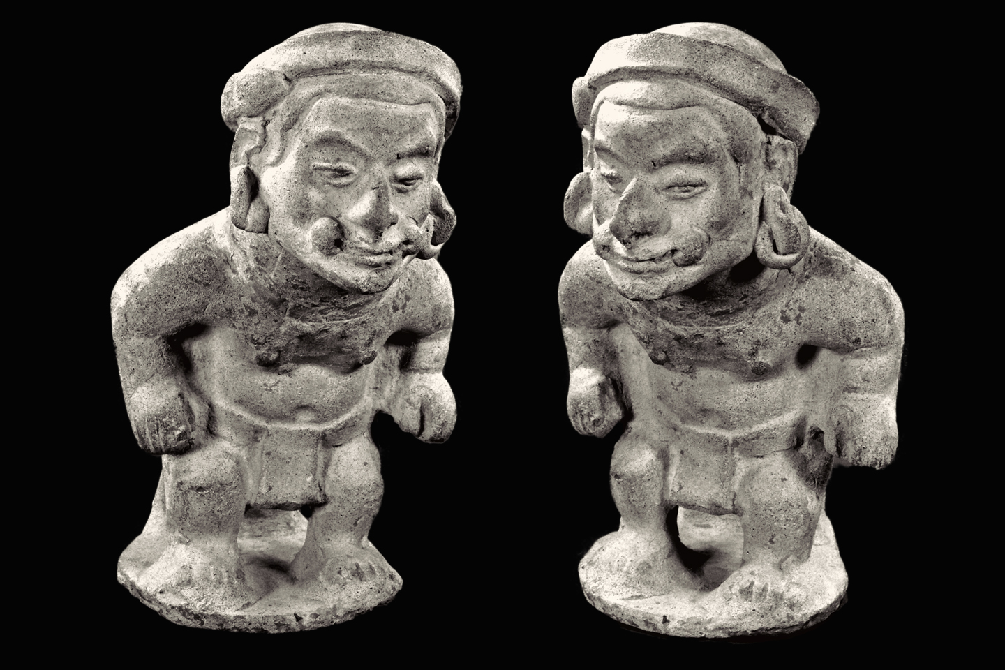
This last example is a complete figurine that represents the pinnacle of Tumaco artistry. The piece is 19 cm in height, and is masterfully executed in three dimensions.

The man is clearly in motion, a Bearer carrying a load in a pack on his back. He’s dressed in a loin cloth, and has big ear spools in distended lobes. The face is particularly expressive with significant detail, including a large, hooked nose, prominent eyebrows, and cheeks bulging with coca, a stimulant that has been used throughout the region for thousands of years.

The support attached to the back of the piece forms a tripod with the two legs, allowing the figurine to stand upright and remain stable; the finished sculpture was clearly intended for display. When this piece was found, the head had separated from the body, and was reattached, as can be seen in the side view (above).

The Bearer was quite likely a real character. The Tumacos, who lived on the coast, traded with people living high in the Andes. There were no roads, and they had no draft animals, so high value trade goods traveled up and down steep trails on the backs of men just like this guy, fortified for the rigors of the climb with a double helping of his favorite chew!


ALL HEADS, NO TAILS

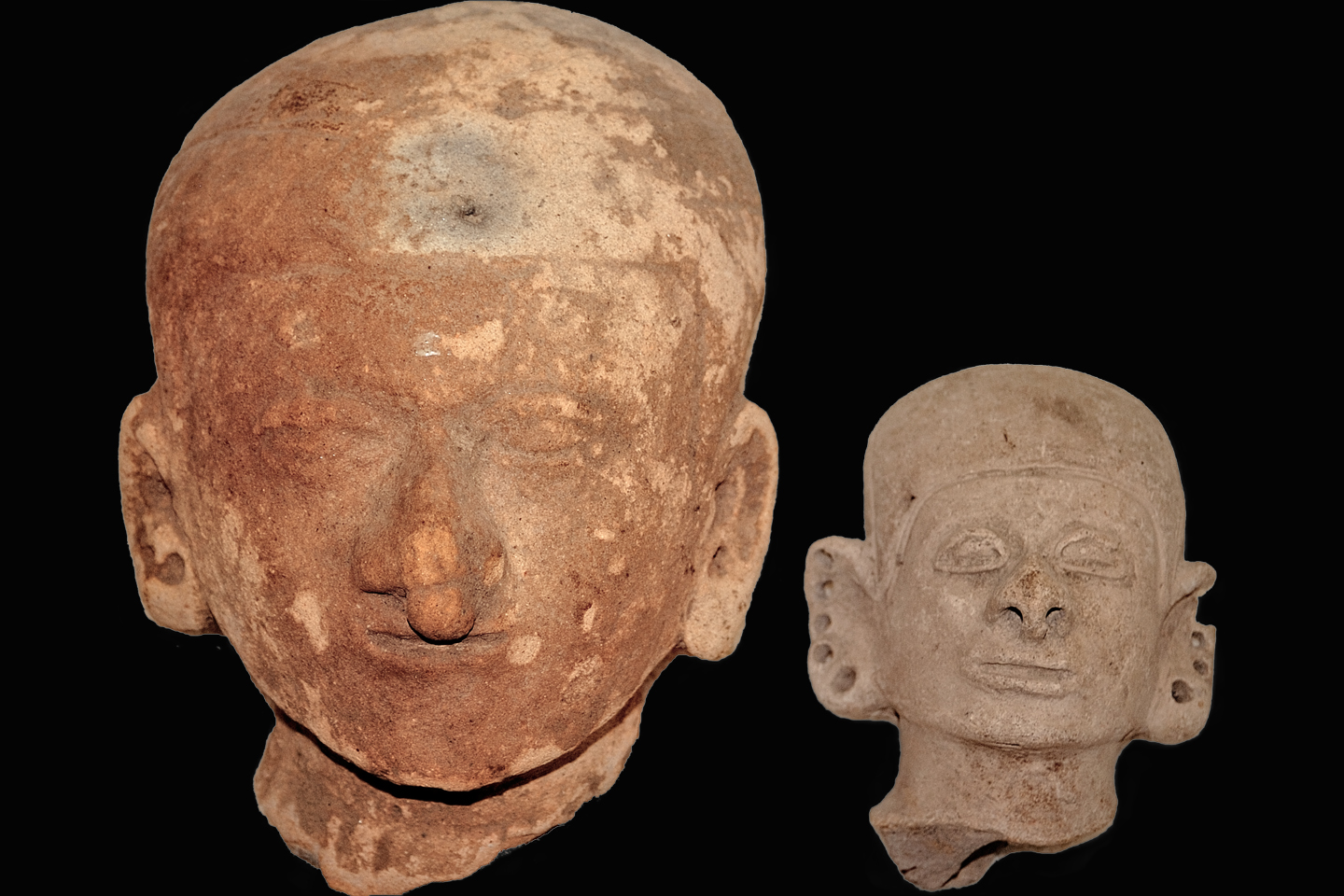
Complete figurines from the Tumaco area are rare. A typical artifact is more likely to be a fragment, sometimes nothing more than a face, like a ghost from a distant past.

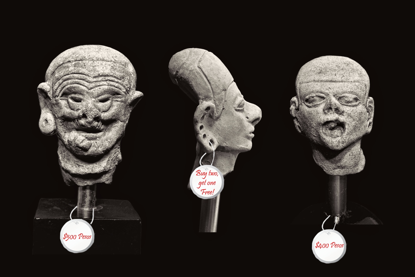
The segments of the figurines of greatest interest to the guaqueros were the heads, because they had value, even when the rest of the piece was hopelessly damaged. “Tumaco Heads,” usually mounted on a small stand, were among the most common items offered for sale in Colombia’s legal antiquities shops, and because each one was unique, customers would often buy several, bartering for a better price, like any common souvenir.

Since there were no restrictions on the export of antiquities, the cultural heritage of the Tumacos poured out of Colombia, packed in the luggage of tens of thousands of tourists, and was scattered all over the globe, so much of it that even today, half a century later, you can pick up an ‘authentic Tumaco Head’ on eBay, any time you like. If you look hard enough, you might even find one at a garage sale.


PORTRAITS IN CLAY

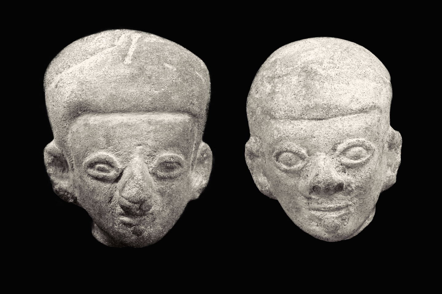
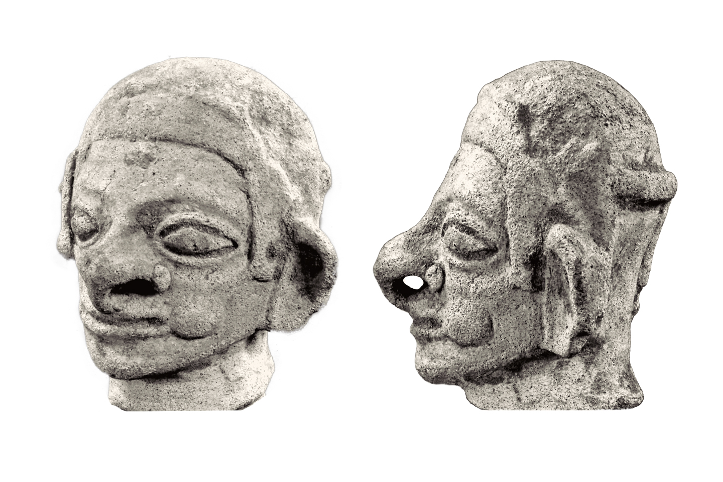
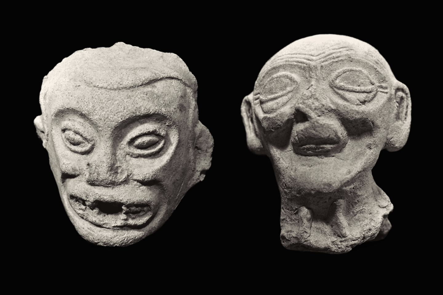
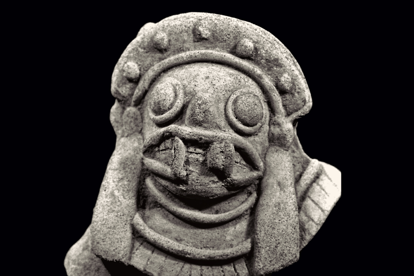
Typical “Tumaco Heads” share a great many similarities: cranial deformation, a fitted cap, ovoid eyes, but there’s probably more to be learned from the differences between them.  In the example on the left (above), the figure has a stud on either side of his nose, as well as a labret–a lip plug–and dimples along the edges of the ears indicating multiple piercings for ear rings.  Such jewelry was made of gold in the real world of the Tumacos, and was a mark of social status. The head on the right is missing most of those features. We can make assumptions, that perhaps the figurines represent individuals of a higher and lower caste; but we would only be guessing.

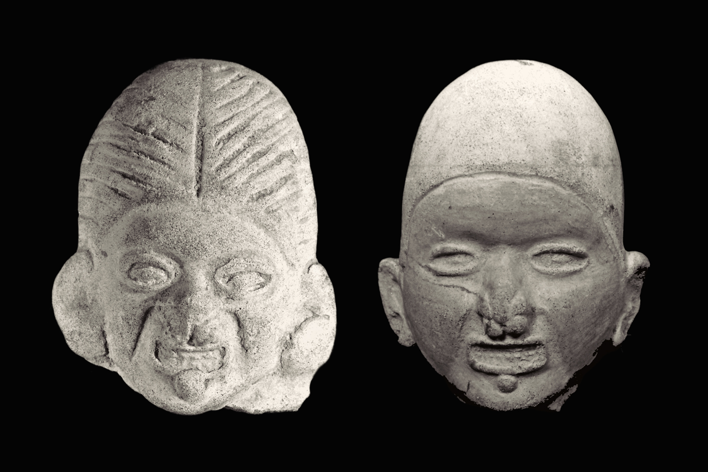
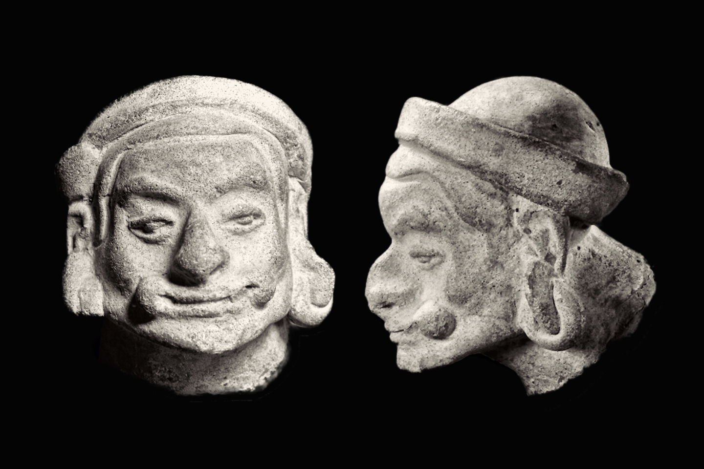
These two pieces (above) share a great many similarities, from the jewelry depicted to the strange rectangular grimace and the display of clenched teeth, but, once again, the differences are of greater significance. The head on the left is missing the traditional cap, instead showing a full head of hair with a part down the middle. Even more important is the manufacturing technique. Both pieces were molded, but the head on the left is solid, while the example on the right is hollow, far more delicate, with a smoother, more finished appearance. We have the same essential theme—the grimacing man—done by different artists, using different techniques. The two pieces clearly represent different phases of the Tumaco culture and are probably separated by hundreds of years, but in the absence of proper excavations, we can’t apply accurate dates to any of these pieces. Whatever the purpose of the figurines, they evolved over time, and the Tumaco artisans got better and better at making them.

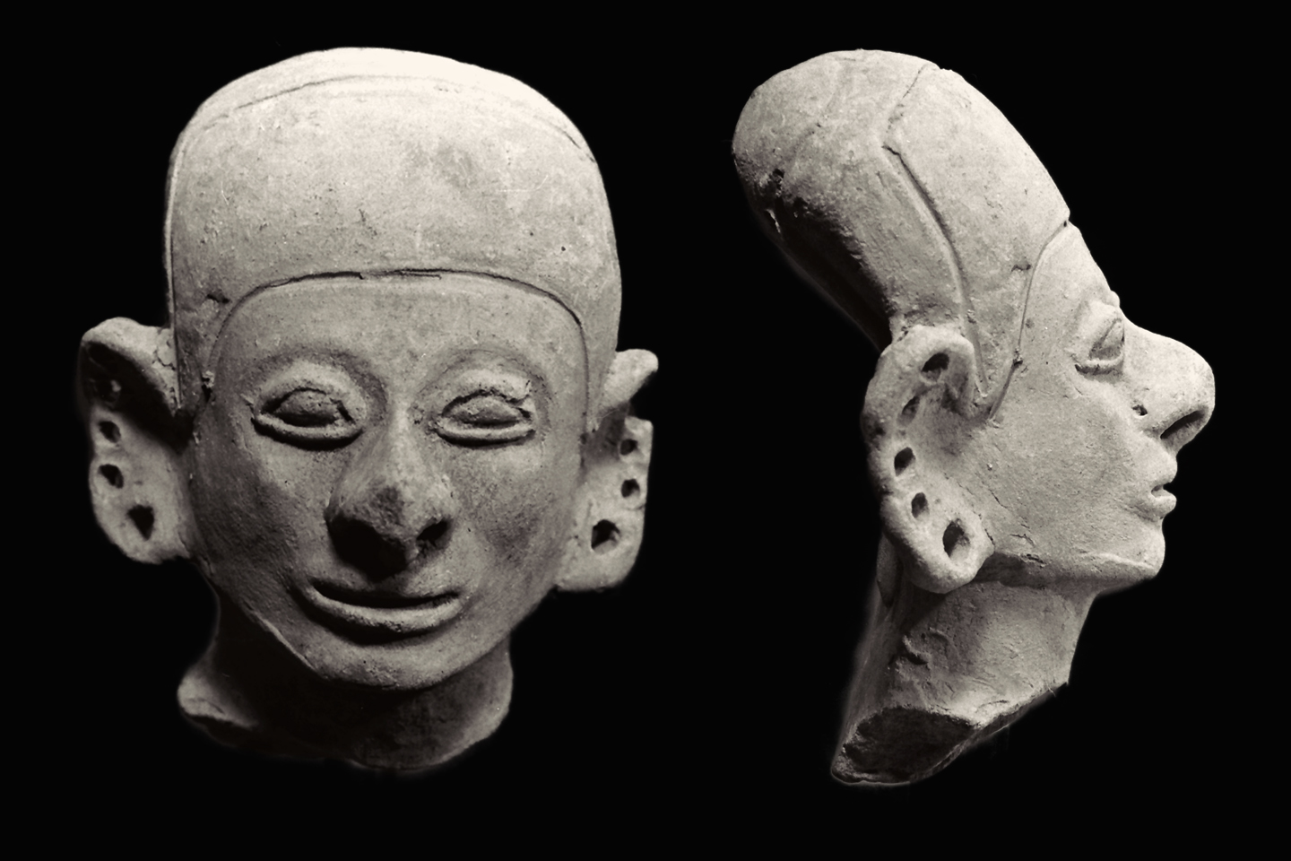
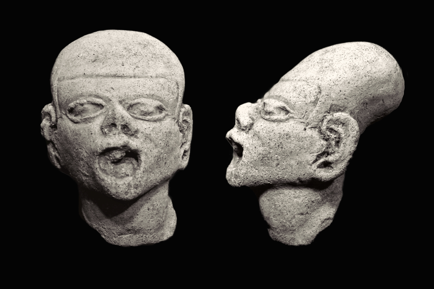
We do know that the figurines were decorated in various ways. They were painted, as evidenced by the traces of original pigment that often remains, and they were sometimes adorned with gold rings. The holes pierced through the edges of the ears on the head pictured above would have served that purpose, as would the hole pierced through the nose on the head pictured below.

The example above has other features worthy of note. The head is finished in all three dimensions, and the face is much more natural, as if modeled from a real person. The nose is quite pronounced, and the left cheek is bulging with a quid of coca leaves, a common feature on Tumaco figurines.

This fragment (above) is clearly a portrait of an individual: a portly gentleman with a pendulous belly, and both cheeks bulging with coca.

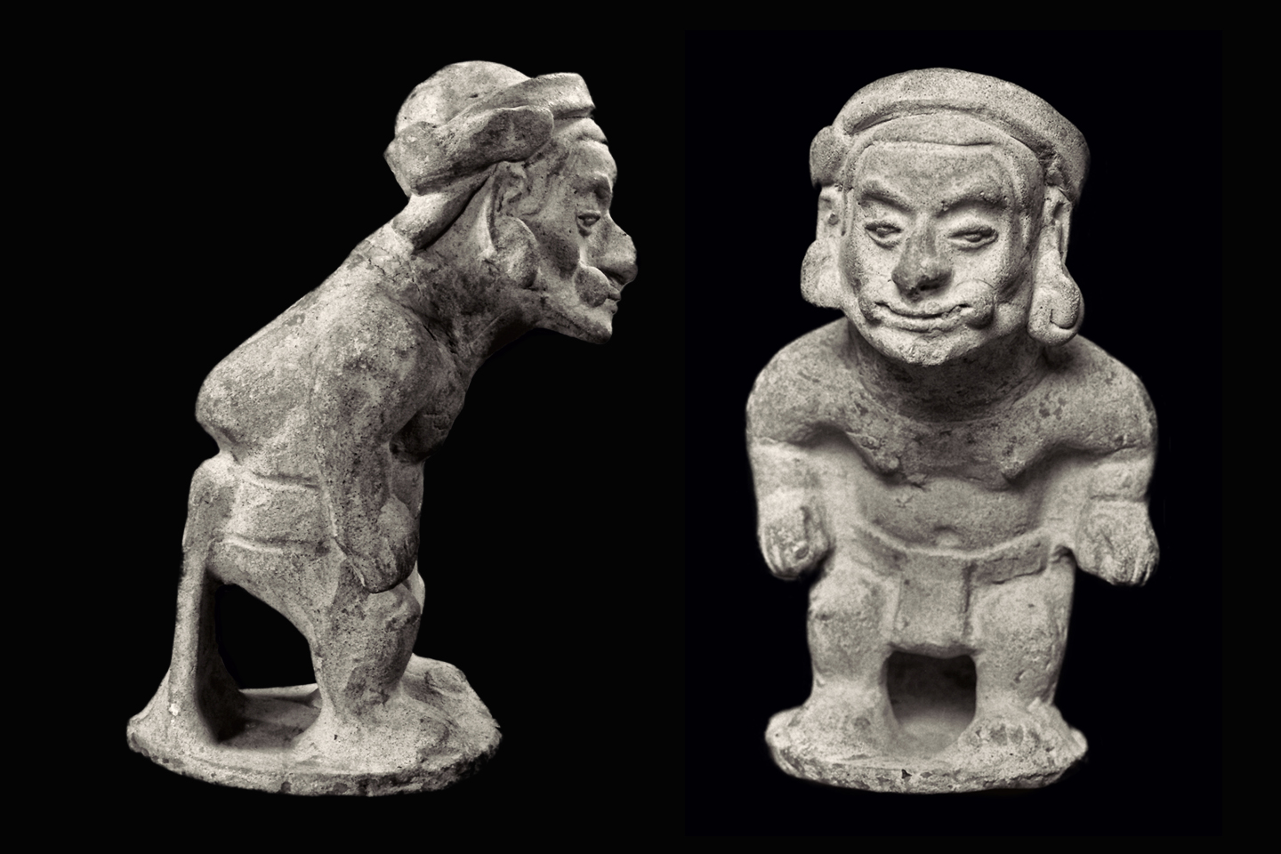
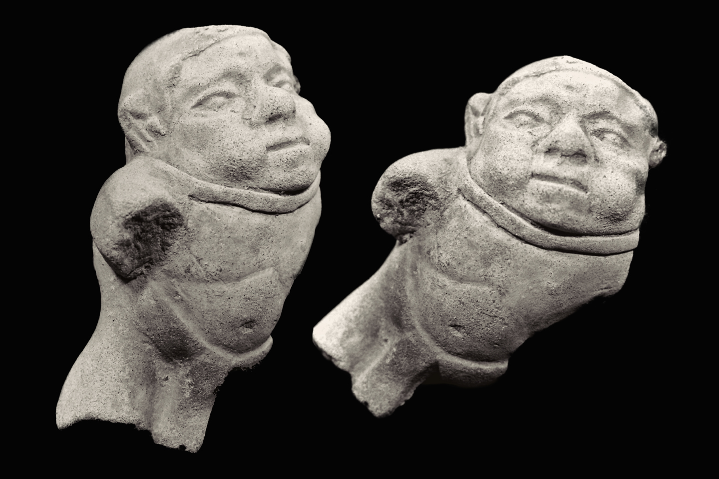
Two views of the head of the “Bearer carrying a load” figurine from the previous section, emphasizing the bulging cheeks.


OLD AGE AND DISEASE:

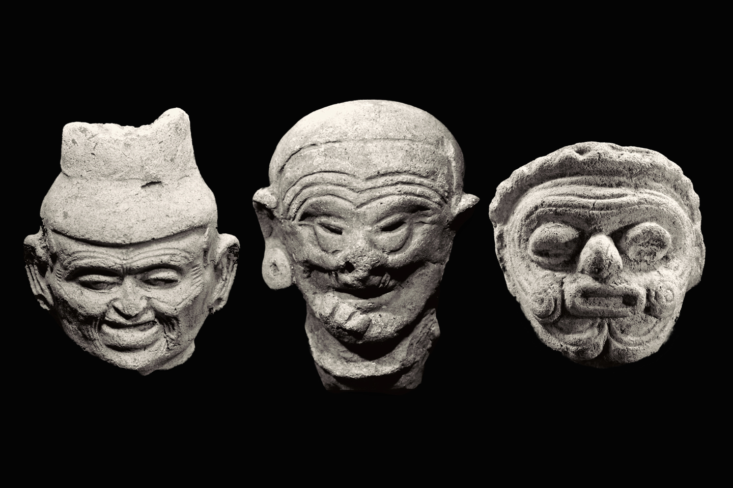
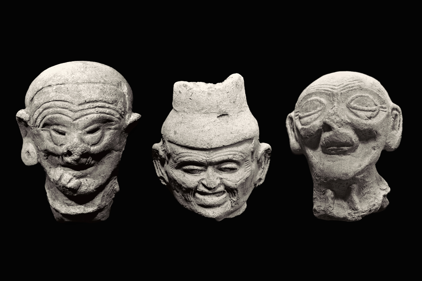
Based on studies of skeletal remains, the median lifespan of Tumaco men was only about 35 years. Clearly, there were exceptions to that rule, as evidenced by the abundance of figurines depicting age. Above is a trio of old men, with deep lines on their foreheads and crow’s feet alongside baggy eyes. The piece on the left is exceptionally expressive, like a true portrait, as is the piece in the center (more on that one below). The head on the right is primitive, more of a caricature. Is the piece on the right from an earlier phase of the culture? Probably, but because these heads were excavated and trafficked by looters, they can’t be accurately dated.

Two more old men from Tumaco. The head on the left is missing most of his teeth, but only the front teeth, as if from an accident. The old gentleman on the right is missing ALL of his teeth, as evidenced by deeply sunken cheeks, and in his case, it’s almost certainly a consequence of age.

Another common element among Tumaco figurines is the depiction of infirmities. The example above shows a man with a growth in his mouth, while the example below shows a man with some sort of tumor, or a goiter, distorting the shape of his face.

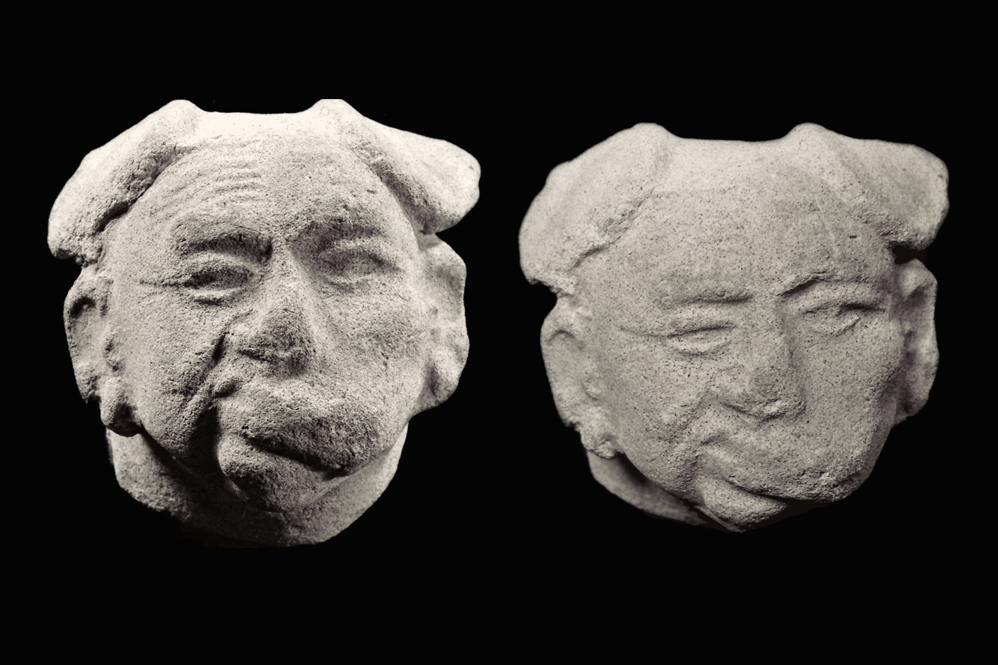
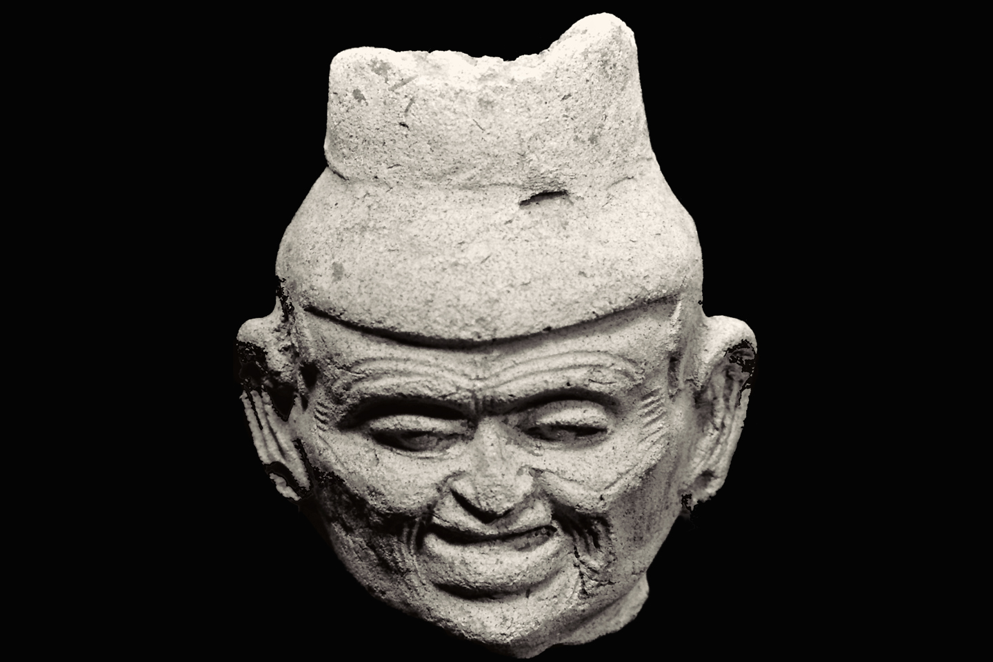
Finally, two more views of the elder in the middle (from the “trio of old men,” above). Furrowed brow, sunken cheeks, baggy eyes, and much of his nose is missing. It may have broken off, or it may have been sculpted that way to represent a disfiguring disease; the latter theory is bolstered by the large growth below the man’s lip.

Some have theorized that the figurines depicting diseases were used in ceremonies that ended with the smashing of the figurine, one way of explaining the fact that so many were broken before they were  buried.  Transference of a malady from a suffering human to a symbolic object is known to occur in some shamanistic rituals, so that’s certainly a possibility.


LARGE SCALE SCULPTURES

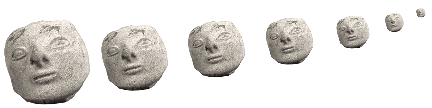
Most Tumaco figurines are of similar size, ranging from 10 cm to around 20 cm in height, but there is a sub-class of clay sculptures that are significantly larger. In this example (above), the head alone measures 14 cm, and the sculpture from which it was broken, if it was still intact, would have been at least 50 cm tall, more than double the normal height.

he large head, pictured side by side with a fragment of the more typical size. The large head is hollow, made of coarse reddish-brown clay. The shell is thick, so the piece is relatively heavy. The head was represented as being from Tumaco, but the composition of the reddish clay would seem to indicate an origin further south.

When archaeological sites are destroyed by looters, and the artifacts are scattered by traders, the world suffers an irrecoverable loss. In the case of the Tumacos, that loss is enormous.

~~~~~

Disclaimer: I am not an academic. The assumptions made and the conclusions drawn in these posts are those of a reasonably well-informed enthusiast; I haven’t put in the work that might make me an expert. At one time, I was up to my neck in this stuff,  but the most that entitles me to is an opinion. 

Unless otherwise noted, all of the images on this site are my original work and are protected by copyright. They may not be duplicated for commercial purposes.  

Click any photo to expand the image to full screen:

If you’re interested in the Tumaco Culture, check back to read the rest of the series. beginning with Tumaco: Part 1: Atrocity Tops Antiquity on the Coast of Colombia.  Next up: Tumaco: Part 3: Cultural Crossroads

MORE SOUTH AMERICAN ADVENTURES:

This is an interactive Table of Contents. Click the pictures to open the pages.

South America Before the Conquistadores

Tumaco: Atrocity Tops Antiquity on the Coast of Colombia

Within a matter of a few years, every readily accessible site had been looted and stripped of artifacts. There were laws in Ecuador prohibiting trade in antiquities, but during the 1970’s, there was no such law in Colombia, so the Tumaco heritage, extraordinary in its complexity, was scattered to the four winds.

<<CLICK to Read More>>

Tumaco: From Out of the Flood

Far more common than the precious metal were the artifacts made of clay, small, often elaborate figurines depicting nearly every aspect of the people’s daily lives, as well as their animistic mythology. It is through those figurines, some intact, but most in fragments, that these all but forgotten people have come to be known.

<<CLICK to Read More>>

Tumaco: A Cultural Crossroads

Traders coming down from the north had to endure many days of difficult travel along a coast that’s tough to negotiate even today. The reward must have been worth the trouble, because men from the Yucatan did, in fact, make that journey, trading goods, as well as ideas with the men of Tumaco.

<<CLICK to Read More>>

Tumaco: The Arhuaco Connection

What we really know of history is like an ancient tapestry, worn, and threadbare, with missing patches confusing the grand design. When we make a new connection, we restore a missing thread, and little by little, thread by thread, we fill in those troublesome blanks.

<<CLICK to Read More>>

Tumaco: Snarling Beasts and Raging Demons

There was so much ancient pottery in the Tumaco area that it literally washed up out of the ground after every big rain. With so many men out there looking for gold, it was impossible NOT to find Tumacan ceramics. Strange figurines and fragmented sculptures, unlike anything that had been found before, anywhere else in Colombia.

<<CLICK to Read More>>

Machu Picchu Sunrise

The five of us had Machu Picchu entirely to ourselves for at least twelve hours. It was like a dream, and a very fine dream, at that.

<<CLICK to Read More>>

In the Vale of the Stone Monkeys: Peril and Petroglyphs in the Colombian Jungle

El Manco was easy to spot; he had embraced his defining handicap, a right arm that had been severed above the elbow, and that wasn’t even his only problem. He was also missing his right eye, nothing there but an empty socket and an ugly knot of scar tissue. “Tough old bird” doesn’t begin to describe a hardscrabble character like Manco; he had a face with creases like a roadmap straight to his own personal version of hell.

<<CLICK to Read More>>

Tairona Gold: The Rape of Bahia Concha

It was the Tairona gold that triggered a blood lust in the Spanish invaders, ultimately causing the destruction of the entire Tairona civilization. That cycle was repeated in modern times, when the lust for Tairona gold infected the guaqueros, causing the destruction of the last refuge of the Tairona ancestors, in one final humiliation, one last indignity: the RAPE of Bahia Concha!

<<CLICK to Read More>>

Tairona Gold: The Curse of the Coiled Serpent

Paul dug with his hands then, finally sticking his arm into a hollow space, pulling out a dark object. Grinning at me from the bottom of his hole, he handed up what he’d found. A round blackware vessel representing a coiled serpent, open in the middle, with a spout at the top of the head. I’d seen a lot of Tairona artifacts, but I’d never seen anything remotely like that one.

<<CLICK to Read More>>

There's nothing like a good road trip. Whether you're flying solo or with your family, on a motorcycle or in an RV, across your state or across the country, the important thing is that you're out there, away from your town, your work, your routine, meeting new people, seeing new sights, building the best kind of memories while living your life to the fullest.

Are you a veteran road tripper who loves grand vistas, or someone who's never done it, but would love to give it a try? Either way, you should consider making the Southwestern U.S. the scene of your own next adventure.

A few years ago I wrote a book about road trips in Arizona and New Mexico that's a lot like this website, packed with interesting information, and illustrated with beautiful photographs. Check it out! You can find it on Amazon, and at all other major booksellers.

ALASKA ROAD TRIP:

Alaska Road Trip: Driving to the Top of the World

The rough dirt road gave way to a newly paved modern highway. This was it, the Top of the World, and right on cue, the haze peeled back, just enough to give me a glimpse of the beauty my friends assured me would be there…

Alaska Road Trip: The Grand Circle: Wrangell-St. Elias National Park

So, just exactly how big is Wrangell-St. Elias National Park? You could combine Yellowstone with Yosemite, throw in the entire country of Switzerland, and you still wouldn’t match it in terms of size.

Alaska Road Trip: The Grand Circle: Anchorage and the Kenai Peninsula

The massive ice field in the park’s wild interior has spawned dozens of glaciers which, over the course of many millenia, have carved the landscape into fjords so heart-breakingly beautiful, humpback whales swim all the way from Hawaii just to cavort in the deep blue water.

Alaska Road Trip: The Grand Circle: From Tok to Denali

There are no icy mountains looming on the horizon, and Fairbanks is nowhere near Alaska’s ruggedly beautiful coast. The true beauty in Alaska’s second city is found below the surface, in the spirit and resiliance of the people who make the place their home.

Alaska Road Trip: Driving Alaska’s Grand Circle

Most of the major towns in Alaska, as well as three of the state’s incredible National Parks, can all be reached by driving Alaska’s Grand Circle: a loop route beginning in Tok that utilizes all four segments (1082 miles) of Alaska’s Interstate Highway system.

Kenai Fjords National Park: Exit Glacier: Up Close and Personal

Compared to the huge tidewater glaciers that flow directly into the sea along the coast of Kenai Fjords, Exit Glacier is just a baby–a baby that’s getting smaller every year–but it’s still big enough to permanently alter the landscape through which it passes.

Kenai Fjords National Park: Seabirds, Glaciers, and Whales on the Wild Coast of Alaska

As the tremendous weight of the moving glacier pushes forward, the pressure buckles the ice into fantastic pillars and columns, like frozen fairy castles gleaming translucent blue as the suspended glacial sediment refracts the sunlight.

Two-Foot High Kick: World Eskimo Indian Olympics

Contestants take a running leap, then they make this crazy jackknife move, touch the ball suspended high above the floor with both feet, then come back down and stick the landing. If that sounds difficult? You have no idea.

Dreaming of Denali

When I drove my Jeep to Alaska that first summer after I retired, my primary goal, the single most important thing I wanted to do, was to see Denali, the biggest mountain in North America.

Chena Hot Springs: A Fairbanks Original

The Chena hot spring puts out steaming water at a temperature of 150 degrees, producing enough power to meet all the needs of the resort, as well as filling the hot springs pools used by the guests. In addition to the lodge and restaurant, they offered camping and horseback riding, and they had exhibits featuring sled dogs, greenhouses, ice sculptures, and geothermal energy.

The Alaska Highway: Day 4: Beaver Creek to Fairbanks

Delta Junction, the end of the Al-Can, was only 200 miles away, and the border? Twenty miles, maybe half an hour, and I was finally going to cross into Alaska! I’d been on the road more than three weeks, and in just half a day more, I’d be in Fairbanks.

The Alaska Highway: Day 3: Whitehorse to Beaver Creek

Approaching the mountains, I started pulling over with serious frequency, taking LOTS of photos! Mountains, clouds, lakes, flowers—I was pretty sure I must have died and gone to heaven, but I couldn’t for the life of me remember the fiery crash.

The Alaska Highway: Day 2: Fort Nelson to Whitehorse

Every time I rounded a curve in the road there was another stupendous vista; it was nothing short of astonishing! I was literally yipping out loud, and a couple of times I actually pulled over and stopped while I pounded on my chest to “re-start” my heart!

The Alaska Highway: Day 1: Dawson Creek to Fort Nelson

Past Fort St. John, the terrain got a lot wilder. No more towns, very few people, and very little traffic. Saw a few U.S. license plates, Michigan, California, Oregon, South Carolina; people that were obviously headed to Alaska!

The Alaska Highway: Prelude: The Road to Dawson Creek

Even if you start in Seattle, the closest American city, it’s still more than 800 miles to Dawson Creek, wending your way that much further north, so far north that there will be a noticeable change in the hours of daylight. It’s the latitude that distinguishes the north country, including every bit of Alaska. Dawson Creek is where it all begins.

Follow the Fireweed

Visualize a summertime journey through that part of the world, a world filled with mountains and glaciers and boreal forests, ice blue rivers, turquoise lakes, and billowing clouds that fill the sky. Imagine your vision as a beautiful piece of music. The fundamental, underlying theme of that symphony would be a gently rising swell of perfect harmony, pinkish lavender in its hue.

MEXICAN ROAD TRIP (IN THE LAND OF THE MAYA):

Mexican Road Trip: Back to the Border: San Miguel de Allende to Eagle Pass

Saltillo was our crossroads: if we turned east here, we’d be retracing our previous route to the border at Nuevo Laredo (along the Highway of Death). This time, we knew better, so we turned north, toward Monclova, and Piedras Negras.

Mexican Road Trip: Three Days of the Dead in San Miguel de Allende

By mid-afternoon, the Jardin was beginning to fill with people. Painted faces were literally everywhere! It was like a costume party, but the venue wasn’t some hall or other indoor space, it was the whole entire town! Mike and I were definitely getting into the spirit of the thing–but we still drew the line at the notion of painting our beards…

Dia de Los Muertos: A Gallery of Photographs

A smorgasbord of colorful images, capturing the essence of the vibrant festival known as the Dia de Los Muertos, in the charming colonial city of San Miguel de Allende.

Mexican Road Trip: Flashing Lights in the Rear View: Officer Plata and La Mordida

As we drove away from the toll plaza, a State Police car that had been parked off to one side made a fast U-Turn and started following me. A moment later, he turned on his flashers and gave me a short blast on his siren, motioning for me to pull over. Two uniformed policemen got out, and approached me on the driver’s side. One of them hung back, apparently checking out my license plate before making a phone call.

I wasn’t sure if I was being stopped for some infraction, or if these guys were just fishing…

Mexican Road Trip: Cruising the Sierra Madre, from San Cristobal to Oaxaca

Today, we’d be driving as far as the city of Oaxaca, 380 miles of curves, switchbacks, and rolling hills that would require at least ten hours of our full attention, crossing the Sierra Madre de Chiapas, and entering the rugged, agave studded landscape of the Sierra Madre de Oaxaca. If you’d like to know what that was like, read on!

Mexican Road Trip: Crossing the Chiapas Highlands, to San Cristobal de las Casas

MX 199 crosses the Chiapas Highlands from Palenque to San Cristobal de las Casas. The distance is only 132 miles, but it’s 132 miles of curvy mountain roads with switchbacks, steep grades, slow trucks, and villages chock-a-block with topes and bloqueos, unofficial road blocks. Everything I read, and everything I heard, described the drive as  alternatively spectacular, dangerous, and fascinating, in seemingly equal measure.

Mexican Road Trip: The Road to Bonampak

Rainwater seeping through the limestone walls of the temple soaked the Bonampak Murals with a mineral-rich solution that, each time it dried, left behind a sheen of translucent calcite. The built-up coating protected the paintings for more than 1200 years. As a result, we’re left with the finest examples of ancient art from the Americas to have survived into our modern era.

Mexican Road Trip: Adventures along the Puuc Route

All of these communities in the Puuc region were allied, politically, culturally, economically, and socially. The Puuc was the cradle of the Golden Age of the Maya. Labna and Sayil were among the brightest jewels in the crown of a realm that never quite coalesced into an empire.

Mexican Road Trip: Edzná, and Campeche, Where They Dance La Guaranducha!

La Guaranducha, a traditional dance from Campeche, is a celebration of life, community, and the joy of existence. On stage, there was a group of young men and women in traditional dress, but it was clear that the guys were little more than props, because all eyes were on the girls. So colorful, and so elegant, hiding coyly behind their pleated, folding hand fans.

Mexican Road Trip: Circling the Yucatan, from Quintana Roo to Campeche

The Castillo at Muyil isn’t huge, as Mayan pyramids go, topping out at just over 50 feet, but it’s definitely imposing. Try to imagine: the equivalent of a five story building, with a three story grand staircase, just appearing, out in the middle of nowhere? Boo-yah!

Mexican Road Trip: Cancun, Tulum, and the Riviera Maya

The millions of tourists who fly directly to Cancun from the U.S. or Canada are seeing the place out of context. They can’t possibly appreciate the fact that they’re 2,000 miles south of the border; a whole country, a whole culture, a whole history away from the U.S.A. Just looking around, on the surface? The second largest city in southern Mexico could easily pass for a beach town in Florida.

Mexican Road Trip: Uxmal vs Chichén Itzá

From the parking lot, the building where they sell the tickets to Uxmal looks a bit like the entrance to a shopping mall, or a multiplex, but the moment you step through the door, you’ll discover that it’s actually a time machine. That entryway is a portal to the world of the ancient Maya, a thousand years into the past. 

Mexican Road Trip: Merida and the Meridanos

Merida is the largest city in southern Mexico, with a population of almost a million. Statistically, Yucatan is the safest of Mexico’s states, and Merida is widely considered the safest of all Mexico’s cities.

Mexican Road Trip: Mayan Ruins and Waterfalls in the Lacandon Jungle

The next morning, we were waiting at the entrance to the Archaeological Park a half hour before they opened for the day. We were the only ones there, so they let us through early, and I had the glorious privelege of photographing that wonderful ruin in the golden light of early morning, without a single fellow tourist cluttering my view.

Mexican Road Trip: Zapatista Road Blocks in Chiapas

“Good morning,” I said. “We’re driving to Palenque. Will you allow us to pass?”

The leader of the group, a young Mayan lad, walked up beside my Jeep, and fixed me with a menacing glare. “The road is closed,” he said, keeping his hand on the hilt of his machete. “By order of the Ejército Zapatista de Liberación Nacional!”

“Is it closed to everyone?” I asked innocently. “How about if we pay a toll? How much would the toll be?”

He gave me an even more menacing glare. “That will cost you everything you’ve got,” he said gruffly, brandishing his machete, while his companions did the same.

Mexican Road Trip: Heading South, from Laredo to Villahermosa

When it was our turn, soldiers in SWAT gear surrounded my Jeep, and an officer with a machine gun gestured for me to roll down my window. He asked me where we were going. I’d learned my lesson in customs, and knew better than to mention the Yucatan. “We’re going to Monterrey,” I said, without elaborating.

He checked our ID’s and our travel documents, then handed them back. “Don’t stop along the way,” he advised. “You need to get off this road and to a safe place as quickly as you can!”

Mexican Road Trip: How to Plan and Prepare for a Drive to the Yucatan

The published threat levels are a “full-stop” deal breaker for the average tourist. That’s unfortunate, because Mexican road trips are fantastic! Yes, there are risks, but all you have to do to reduce those risks to to an acceptable level is follow a few simple guidelines.

Day of the Dead in San Miguel de Allende

In San Miguel de Allende, they’ve adopted a variation on the American version of Halloween and made it a part of their Day of the Dead celebration. Costumed children circle the square seeking candy hand-outs from the crowd of onlookers. It’s a wonderful, colorful parade that’s all about the treats, with no tricks!

Chichén Itzá: Requiem for the Feathered Serpent

The feathered serpent with the unquenchable thirst for blood may be gone now, or at least fallen out of favor, but as long as the ruins of this ancient city remain standing, he won’t be forgotten.

Tulum: The City that Greets the Dawn

Tulum is not all that large, as Mayan cities go, but its spectacular location, right on the east coast of the Yucatan Peninsula, makes it one of the best known, and definitely one of the most picturesque. 

The Mayan City of Edzná, First House of the Itzás

The Mayan city of Edzná is nothing less than epic, lyrical poetry, an extraordinary sonnet comprised of temples and palaces carved in stone that have stood, in regal grandeur, for more than a thousand years.

Uxmal: Architectural Perfection in the Land of the Maya

The Pyramid of the Magician is the most impressive monument I’ve ever seen. There’s a powerful energy in that spot–something to do with all the blood that was spilled on the altars of human sacrifice at the top of those impossibly steep steps. More than any ancient ruin I’ve ever visited, more than any demonic ancient sculpture I’ve ever seen, that pyramid at Uxmal flat scared the hell out of me!

The Amazing Mayan Murals of Bonampak

Out of that handful of Mayan sites where mural paintings have survived, there is one in particular that stands head and shoulders above the rest. One very special place. Down by the Guatemalan border, in a remote corner of the Mexican State of Chiapas: a small Mayan ruin known as Bonampak.

Palenque: Mayan City in the Hills of Chiapas

Palenque! Just hearing the name conjures images of crumbling limestone pyramids rising up out of the the jungle, of palaces and temples cloaked in mist, ornate stone carvings, colorful parrots and toucans flitting from tree to tree in the dense forest that constantly encroaches, threatening to swallow the place whole.

San Miguel de Allende, Mexico’s Colonial Gem

If you include the chilangos, (escapees from Mexico City), close to 20% of the population of San Miguel de Allende is from somewhere else, a figure that includes several thousand American retirees.

Southern Colonials: Merida, Campeche, and San Cristobal

Visiting the Spanish Colonial cities of Mexico is almost like traveling back in time. Narrow cobblestone streets wind between buildings, facades, and stately old mansions that date back three hundred years or more, along with beautiful plazas, parks, and soaring cathedrals, all of similar vintage.

The Puuc Hills: Apex of Mayan Architecture

The Puuc style was a whole new way of building. The craftsmanship was unsurpassed, and some of the monumental structures created in this period, most notably the Governor’s Palace at Uxmal, rank among the greatest architectural achievements of all time.

Becan and Chicanna: Mayan Cities in the Rio Bec Style

Much about the Rio Bec architectural style was based on illusion: common elements include staircases that go nowhere and serve no function, false doorways into alcoves that end in blank walls, and buildings that appear to be temples, but are actually solid structures with no interior space.

Coba and Muyil: Mayan Cities in Quintana Roo

Coba was a trading hub, positioned at the nexus of a network of raised stone and plaster causeways known as the sacbeob, the white roads, some of which extended for as much as 100 kilometers, connecting far-flung Mayan communities and helping to cement the influence of this powerful city.

Photographer’s Assignment: Chichen Itza

To get the best photos, arrive at the park before it opens at 8 AM. There will only be a handful of other visitors, and you’ll have the place practically all to yourself for as much as two hours! Take your time composing your perfect shot.There won’t be a single selfie stick in sight.

ARIZONA AND NEW MEXICO:

San Xavier del Bac: The White Dove of the Desert

San Xavier has all of the traditional elements of a Spanish Colonial church, along with many others that are quite unique. The craftsmanship of the original building is superb, and features many fascinating details.

Granada Park: An Avian Oasis in the Heart of Phoenix

Granada Park is a City Park that’s adjacent to a Mountain Preserve. Its location, along with certain other advantages, make it unique in some very specal ways.

A Sunset at White Sands

Dropping down out of the Sacramento Mountains near Alamogordo, the sky was filled with the colors of the widest rainbow I’ve ever seen. Down on the flat, another rainbow came spearing down through the clouds before setting out in pursuit of a downpour, off in the middle distance.

New Mexico’s Golden Autumn

When you think of autumn foliage, the list of places that comes to mind is much more likely to include New England than New Mexico–but the Land of Enchantment is full of fall surprises!

Grand Canyon Rafting

You find a rope, any rope, and you grab on with both hands for all you’re worth. The river boils like the North Sea in a gale, great, rolling green waves and troughs. The raft plummets sideways into a hole fifteen feet deep, the outboard motor shrieks, a monster wave towering ten feet above your head comes crashing down across the deck, pummeling the passengers like a gigantic liquid fist that takes your breath away, leaving you suspended, time stopped, frozen in mid-scream.

Grand Canyon Rafting Expedition: Day One

The two rafts were shoved away from the beach until they floated free, and the boat drivers eased them into the middle of the channel.  We were mostly moving with the current, but the beach dropped behind us pretty quickly, and in a matter of minutes we were out there, rafting down the Colorado River, heading squarely into the enchanted depths of the Grand Canyon.

Grand Canyon Rafting Expedition: Day Two

The cliffs and buttes were a perfect composition, the different colored layers of stone were all but glowing in the afternoon light, and we had this incredible world all to ourselves, not another boat in sight. 

Grand Canyon Rafting Expedition: Day Three

The waters of the Little Colorado are a turquoise blue that is so startlingly bright it doesn’t even look real.  There’s a well-defined spot where that warm, turquoise blue water from the small river collides with the cold, deep green water flowing upstream from the big river. The two dramatically different colors mix, forming a shifting, swirling line of chartreuse.  That spot is the confluence. It’s magical, and utterly unique.

Grand Canyon Rafting Expedition: Day Four

I was still a little dazed by the whole thing, scenes of frothing, churning whitewater playing over and over in my head.  Fleecy white clouds were piling up above the canyon rim, nearly filling the narrow patch of sky, until the lowering sun set them afire, a Grand Canyon sunset display that was the finest we’d seen, worthy of the spectacular setting.  A fitting end to one of the most amazing days of my life.

Grand Canyon Rafting Expedition: Day Five

The trail meandered for a mile or so, finally giving us access to a series of perfect swimming holes.  There’s something about that exotic turquoise water that welcomes swimmers; the creek was cool, but far from cold, and a welcome change from the icy water in the river.  We stopped at an inviting spot to swim, relax, and eat our lunch. Sitting beside that creek, with our simple repast–it was like having a picnic in the Garden of Eden. 

Grand Canyon Rafting Expedition: Day Six

“Two Hander!” John called out, and we all clung to the ropes for dear life as the raft picked up speed.  We were headed straight for the boil of Lava Falls, roaring like a freight train, bearing down. We entered the churning whitewater dead center, then moved hard to the right to avoid the standing waves and the big holes in the middle of the channel.  We got good and drenched, almost like running under a series of waterfalls, bucking and lurching like crazy, but the whole thing was over in less than a minute. 

Grand Canyon Rafting Expedition: Day Seven

Immediately below that beach we hit Diamond Creek Rapid, then Travertine Rapid, where we pulled over to the bank at Travertine Canyon.  The creek that entered the river here flowed across huge, slippery boulders in a series of small waterfalls, and we had great fun taking turns standing in the flow, almost like a natural shower.

Grand Canyon Rafting Expedition: Day Eight

The river broadened as we approached Lake Mead, and at mile 278 we entered the lake itself.  Pearce Ferry was right there, and we were all pretty quiet as the rafts pulled in to shore for the last time. “Thrill of a lifetime” is a pretty strong statement, but it’s appropriate for this journey.  There’s nothing else like it.

SOUTH AMERICA:

Magnificent Monoliths: The Enigmatic Idols of San Agustin

At least 200 monolithic statues are preserved within the boundaries of the San Agustin Archaeological Park, along with 20 monumental burial mounds. Each statue is unique, but taken as a group they provide a fascinating overview of the rituals and beliefs of one of the earliest complex societies in the Americas. The enigmatic idols of San Agustin are truly unmatched among the world’s ancient monuments.

An Overabundance of Bowlers: A Brief History of the Headgear on the High Plateau

Andean natives have adapted to the intensity of the high altitude sun by taking a very simple precaution: everyone, almost without exception, wears a hat when they venture outdoors. From infants to ancients, everyone covers their head with something, ranging from shawls to leather helmets to proper English bowlers.

Chinchero: The Place Where Rainbows are Born

Candid portraits of villagers in traditional dress, taken in Chinchero, Peru in 1971, before the outside world intruded.

Children of the Altiplano

Candid portraits of Andean villagers taken in Peru and Bolivia in 1971. This set of photographs focuses on the children: their joy, and their innocence.

Puno Day Festival: A Centuries-Old Tradition on the Shores of Lake Titicaca

Historic photos of Peru’s Puno Day festival, taken in 1971. Included is the reenactment of the birth of the Inca empire on the shore of Lake Titicaca, with costumed dancers lining the streets of Puno.

Portraits of a People, Lost in Time

50 year old portraits of Andean natives in their traditional dress, taken in mountain villages not yet tainted by outside influences.

In the Vale of the Stone Monkeys: Peril and Petroglyphs in the Colombian Jungle

El Manco was easy to spot; he had a right arm that had been severed above the elbow, and that wasn’t his only problem. He was also missing his right eye, nothing there but an ugly knot of scar tissue. “Tough old bird” doesn’t begin to describe a hardscrabble character like Manco; he had a face with creases like a roadmap straight to his own personal version of hell.

Tumaco: The Arhuaco Connection

What we really know of history is like an ancient tapestry, worn, and threadbare, with missing patches confusing the grand design. When we make a new connection, we restore a missing thread, and little by little, thread by thread, we fill in those troublesome blanks.

Tairona Gold: The Curse of the Coiled Serpent

Paul dug with his hands then, finally sticking his arm into a hollow space, pulling out a dark object. Grinning at me from the bottom of his hole, he handed up what he’d found. A round blackware vessel representing a coiled serpent, open in the middle, with a spout at the top of the head. I’d seen a lot of Tairona artifacts, but I’d never seen anything remotely like that one.

Tairona Gold: The Rape of Bahia Concha

It was the Tairona gold that triggered a blood lust in the Spanish invaders, ultimately causing the destruction of the entire Tairona civilization. That cycle was repeated in modern times, when the lust for Tairona gold infected the guaqueros, causing the destruction of the last refuge of the Tairona ancestors, in one final humiliation, one last indignity: the RAPE of Bahia Concha!

Machu Picchu Sunrise

The five of us had Machu Picchu entirely to ourselves for at least twelve hours. It was like a dream, and a very fine dream, at that.

PHOTOGRAPHY:

Photographer’s Assignment: Mount Rainier

The road to Sunrise Park climbs into the foothills of Mount Rainier on the eastern side. The volcano is the biggest mountain around, and the treeless upper slopes, cloaked in glacial ice, catch and reflect the full brunt of the rising sun’s bright rays; a spectacle well worth the long drive, and the early wake-up call.

Photographer’s Assignment: Crater Lake

It simply isn’t possible to gaze upon Crater Lake and not be awed by the view. It’s like staring into the eye of the Creator, a heavenly vision reflected by water so clear, and so deep, and so intensely BLUE, you’ll find yourself neglecting to breathe.

Granada Park: An Avian Oasis in the Heart of Phoenix

Granada Park is a City Park that’s adjacent to a Mountain Preserve. Its location, along with certain other advantages, make it unique in some very specal ways.

Kenai Fjords National Park: Seabirds, Glaciers, and Whales on the Wild Coast of Alaska

As the tremendous weight of the moving glacier pushes forward, the pressure buckles the ice into fantastic pillars and columns, like frozen fairy castles gleaming translucent blue as the suspended glacial sediment refracts the sunlight.

Dreaming of Denali

When I drove my Jeep to Alaska that first summer after I retired, my primary goal, the single most important thing I wanted to do, was to see Denali, the biggest mountain in North America.

A Sunset at White Sands

Dropping down out of the Sacramento Mountains near Alamogordo, the sky was filled with the colors of the widest rainbow I’ve ever seen. Down on the flat, another rainbow came spearing down through the clouds before setting out in pursuit of a downpour, off in the middle distance.

Photographing the Sunrise at the Lincoln Memorial

The slightly elevated position of the Lincoln Memorial gives photographers a clear line of sight from every vantage point, with a multitude of options for interesting compositions. But if you want the very best light, and the smallest crowds, you’re going to have to get out there at sunrise!

The Many Moods of the Jefferson Memorial

As a subject for photographers, the Jefferson has it all: columns and curves, sculpture, carved inscriptions, a dome! The Tidal Basin serves as a reflecting pool, and, for a couple of weeks every spring, the whole business is surrounded by flowering cherry trees.

Washington D.C., By the Dawn’s Early Light

Each weekend I’d focus on a different monument, and I’d shoot them from every conceivable angle, before, during, and after the golden hour of the sunrise. Why the weekend? Because, grasshopper, on weekend mornings, there are no commuters, so there is no traffic, no parked cars, no people in the way of your photo shoot!

New Mexico’s Golden Autumn

When you think of autumn foliage, the list of places that comes to mind is much more likely to include New England than New Mexico–but the Land of Enchantment is full of fall surprises!

Blossoms by the Billions: Photographing the Cherry Blossoms in Washington D.C.

Shoot the flower buds when they first emerge, shoot them again when they’re in full florescence, and if you can swing it, one last time when they start to drop, and you have pink petals falling around you like rain…

Follow the Fireweed

Visualize a summertime journey through that part of the world, a world filled with mountains and glaciers and boreal forests, ice blue rivers, turquoise lakes, and billowing clouds that fill the sky. Imagine your vision as a beautiful piece of music. The fundamental, underlying theme of that symphony would be a gently rising swell of perfect harmony, pinkish lavender in its hue.

Antelope Canyon: Conjuring a Beam of Light: Take 2

Today, thanks to Instagram, Pinterest, Facebook, and all the other photo sharing sites out there, every human on the face of the earth knows about Antelope Canyon, and the volume of visitors has mushroomed into the millions. Instagram, alas, is its own worst enemy,

Buffalo Sunrise: Grand Teton National Park

We could have planned our photo shoot, set up for it, and no doubt we would have gotten even BETTER pictures. But if we’d done that? We would have missed out on the jaw-dropping surprise of a completely unexpected herd of wild buffalo! At sunrise! In the Grand Tetons! That kind of a surprise? It’s almost enough to make your eyeballs explode. It’s just about the very best feeling there is, in this whole big beautiful world!

Photographer’s Assignment: Chichen Itza

To get the best photos, arrive at the park before it opens at 8 AM. There will only be a handful of other visitors, and you’ll have the place practically all to yourself for as much as two hours! Take your time composing your perfect shot.There won’t be a single selfie stick in sight.

Antelope Canyon: Conjuring a Beam of Light

Ephemeral “God beams” appear like magic in the confined space, slanting across the canyon floor like spotlights on a theater stage, only to disappear after a few minutes as the earth spins another fraction of a degree, breaking the perfect alignment.

Antelope Canyon: Part 1

Slot canyons are formed, over the course of many thousands of years, when torrents of rainwater borne from the monsoon storms of summer sluice through channels and cracks in the soft sandstone. Powerful floods strike repeatedly, carving narrow, twisting pathways into the cross-bedded layers of rock, sculpting swirling formations that look like petrified waves.

TRIBAL LANDS:

Canyon de Chelly: The Oldest White House

At the center of the upper section is a large room, 12 by 20 feet, with a front wall that is 12 feet high and made of stone that is two feet thick. This wall was coated in white plaster, decorated with a yellow band, and it is this white wall, which can still be seen, that inspired the name La Casa Blanca, the White House, to this ancient dwelling that has endured in this place for nearly a thousand years.

Canyon de Chelly: Riding the Rainbow to the Universe: The Legend of Spider Woman

Viewing Spider Rock from below provides a dramatically different perspective on this extraordinary formation. From above, you’re looking down on the whole tableau, and Spider Rock, shorter than the soaring canyon walls, appears as one small part of the larger scene. From below, from the floor of the canyon looking up at it, you can see just how BIG the danged thing is. At 800 feet in height, it’s a good bit taller than your average 50 story sky scraper, and it completely dominates the landscape.

Canyon de Chelly: Part 4: The Road to Spider Rock

The twin pillars of Spider Rock were left behind, like a pair of stubborn hold-outs, when everything else around them slowly weathered away. To me, these are fingers of cosmic proportions, thrusting from the earth, pointing toward the heavens in a gesture of unity. When you view these monolithic towers, you will be captivated by their majesty, and by the sheer insolence of their improbable existence.

Canyon de Chelly: Blue Bull and Mummy Cave

300 feet above the canyon floor, there are two deep alcoves filled with ruins, and on a wide ledge between them, a large, multi-story pueblo, partially reconstructed, and quite impressive. The setting is a natural amphitheater, and the overall aspect of the place is simply stunning.

Canyon de Chelly: Standing Cow: A Home Among the Ruins

The hogan, much newer than the other structures, was built using sandstone bricks recycled from the surrounding ruins. Today, even though it’s not really ancient, Standing Cow is on all the maps, as much a part of the human landscape of Canyon de Chelly as the White House and the Mummy Cave.

Canyon de Chelly: Antelope House Ruin

Of all the ruins and other archaeological sites in Canyon de Chelly, Antelope House is the most thoroughly investigated. That’s at least partially due to simple ease of access: unlike most of the ruins in the canyon, all the primary structures at this site are at ground level. Researchers have found the remains of several different cultures in the stratified soil beneath the ruins, each group contributing to the timeline of an area that’s exceptionally rich in history.

Canyon de Chelly: Ruins and Rock Art

We got out, and walked through the trees to a place where a thirty-foot long segment of the sandstone cliff had crumbled away near the base, leaving a section of wall that was set back a couple of feet, protected by an overhang. We could see black pictographs of horses and riders filling that rough stone canvas from left to right.

Canyon de Chelly: Part 3: Canyon del Muerto

The left hand fork is the spectacular work of nature known as Canyon del Muerto. The star attraction of this route is the Mummy Cave Ruin, the largest in the area, built on a ledge between a pair of deep caves, high on the face of a cliff in an extraordinary natural amphitheater.

Canyon de Chelly: Where Canyons Collide

“First Ruin is right over there!” Sylvia pointed to our left, where segments of ancient adobe walls filled a natural alcove halfway up the side of the cliff.

“First Ruin. Wait, don’t tell me. Do they call it that because it’s the oldest?”

“No,” she said with a chuckle. “They call it First Ruin, because it’s the first ruin that we see!”

Canyon de Chelly: Kokopelli and the Lightning Spear

I was probably getting a bit starry-eyed at that point. Barely three miles into the canyon, we’d traveled a thousand years in just under a hundred minutes, and we were barely even underway!

Canyon de Chelly: Ancient Stories Etched in Stone

The petroglyphs we’d just seen, and those we were about to see, were an artistic expression of the highest order, representing the hopes, the dreams, and the spiritual quest of the ancients who created them. These symbols, laboriously etched in stone, were left there for our benefit, and if there are lessons to be learned, we’d be well advised to take heed.

Canyon de Chelly: A Timeless Journey into the Heart of the Navajo Nation

Our first stop was a prehistoric bulletin board Sylvia called Newspaper Rock. A smooth segment of cliff face coated with dark desert varnish, featuring an area at least forty feet wide filled hundreds of petroglyphs. The intriguing symbols were created hundreds of year ago by artists who pecked away the dark varnish, exposing the lighter colored rock underneath.

Canyon de Chelly: Part 2: Chinle Wash to the Junction

A Navajo guide can take you into the canyon in their SUV, or, if you prefer, you can join a guided hike, or a trail ride on horseback. The standard Jeep tours, which are the most popular, range from three to six hours in length. The longer tours cover the highlights of both Canyon De Chelly, and Canyon del Muerto.

Canyon de Chelly: The North Rim Drive

The payoff at the Overlook is a fabulous bird’s-eye view of a quite wonderful Anasazi ruin known as the Antelope House. You can still see the crumbling foundations of dozens of rooms, a tower, and at least four circular kivas, special rooms used by the Ancestral Pueblo people for religious ceremonies.

Canyon de Chelly: Overlooking the White House

The White House Overlook offers a fabulous panorama of the Canyon, and an unobstructed view of the White House, one of the best preserved ruins in the National Monument. Set into a sheer cliff striped with desert varnish, the tableau is instantly recognizable as one of the best-known photographs of Ansel Adams, who once described Canyon de Chelly as “the most beautiful place on earth.” He shot some of his favorite images from the canyon rim.

Canyon de Chelly: The South Rim Drive

The canyon is filled with fascinating contrasts between the cliff dwellings of the Anasazi and the archaic way of life of the Navajo. These views into the canyon literally transcend time.

Canyon de Chelly: Part 1: The Rim Drives

Canyon de Chelly is so much more interesting than the Grand Canyon, because it also has a history, a fascinating history that actually comes alive when you view it up close. Native people have lived in this canyon for almost 5,000 years, which is a very long time indeed, by any standard. What those ancients left behind is the most extraordinary concentration of cliff dwellings and rock art panels to be found anywhere in the desert southwest.

A Serendipitous Sunset at Shiprock

I noticed an odd rock formation coming up fast on the left side of the road, almost like a wall built of angular blocks. Shiprock was close, but hidden from view by the wall as I zoomed toward it. After I passed the odd formation, I stole a quick glance in my rearview mirror, and what I saw was a scene so other-wordly, it literally stopped me in my tracks:

Antelope Canyon: Conjuring a Beam of Light: Take 2

Today, thanks to Instagram, Pinterest, Facebook, and all the other photo sharing sites out there, every human on the face of the earth knows about Antelope Canyon, and the volume of visitors has mushroomed into the millions. Instagram, alas, is its own worst enemy,

Antelope Canyon: Conjuring a Beam of Light

Ephemeral “God beams” appear like magic in the confined space, slanting across the canyon floor like spotlights on a theater stage, only to disappear after a few minutes as the earth spins another fraction of a degree, breaking the perfect alignment.

Antelope Canyon: Part 1

Slot canyons are formed, over the course of many thousands of years, when torrents of rainwater borne from the monsoon storms of summer sluice through channels and cracks in the soft sandstone. Powerful floods strike repeatedly, carving narrow, twisting pathways into the cross-bedded layers of rock, sculpting swirling formations that look like petrified waves.